With Summer-like weather now in full effect, we know exactly what to expect for the next several months, and next week is no exception.
With the high pressure system this weekend breaking down come tomorrow, we’ll see some on and off rain chances for Monday as there is still some moisture left for the ridge to pull. The atmosphere is at a bit of standstill with little dynamic movement which was contributing to the ridge’s dominance. However, the stationary front in Texas will begin to make its move and with it, more rain chances, but this time coming in from the north.
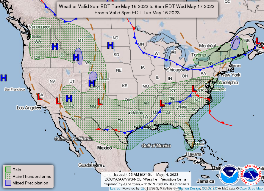
Tuesday and Wednesday both have higher rain chances as the cold front propagates further southward. Most of these storms will be afternoon as they’ll require some heat to get the air parcels going, but expect up to a quarter inch of rain with some of the storms. While these won’t be severe, lightning and some flash flooding are possible.
Thursday and Friday will be our cooler, drier days as we await the next cold front. Highs will be in the middle to upper 80’s with rain chances fairly limited to some pop-up isolated thunderstorms. Looking into the weekend, another cold front out in Canada carries a rain trail with it to possibly rain out our Saturday and another low attaches to it to pull it out just in time on Sunday, so rain chances will be low again with nicer weather to end the weekend.
[wpcode id=”41179″]
Regional Day-to-Day Forecast
This Afternoon – A 20 percent chance of showers and thunderstorms after 3pm. Sunny, with a high near 93. Calm wind becoming north around 5 mph.
Tonight – A 10 percent chance of showers and thunderstorms before 7pm. Mostly clear, with a low around 68. North wind around 5 mph becoming calm.
Monday – A 50 percent chance of showers and thunderstorms, mainly after 2pm. Increasing clouds, with a high near 93. Calm wind becoming north around 5 mph in the morning. New rainfall amounts between a half and three quarters of an inch possible.
Monday Night – A 20 percent chance of showers and thunderstorms before 1am. Partly cloudy, with a low around 68. North wind around 5 mph becoming calm.
Tuesday – Showers and thunderstorms likely, mainly after 1pm. Mostly sunny, with a high near 90. Light west southwest wind becoming west 5 to 10 mph in the morning. Chance of precipitation is 60%. New rainfall amounts between a tenth and quarter of an inch, except higher amounts possible in thunderstorms.
Tuesday Night – A 20 percent chance of showers and thunderstorms before 1am. Mostly cloudy, with a low around 68. Southwest wind around 5 mph becoming calm in the evening.
Wednesday – Showers and thunderstorms likely, mainly after 1pm. Partly sunny, with a high near 83. Calm wind becoming west northwest around 5 mph in the morning. Chance of precipitation is 70%.
Wednesday Night – Mostly cloudy, with a low around 65. Northwest wind around 5 mph becoming calm in the evening.
Thursday – A 30 percent chance of showers and thunderstorms after 1pm. Mostly sunny, with a high near 84. Calm wind becoming north around 5 mph in the afternoon.
Thursday Night – Mostly clear, with a low around 64.
Friday – A 20 percent chance of rain and thunderstorms. Sunny, with a high near 87.
Friday Night – Mostly clear, with a low around 66.
Saturday – A 40 percent chance of showers and thunderstorms. Mostly sunny, with a high near 87.
[wpcode id=”41149″]


