PTC isn’t Claudette, yet. Yet, it is trying its best to wrap itself up before landfall.
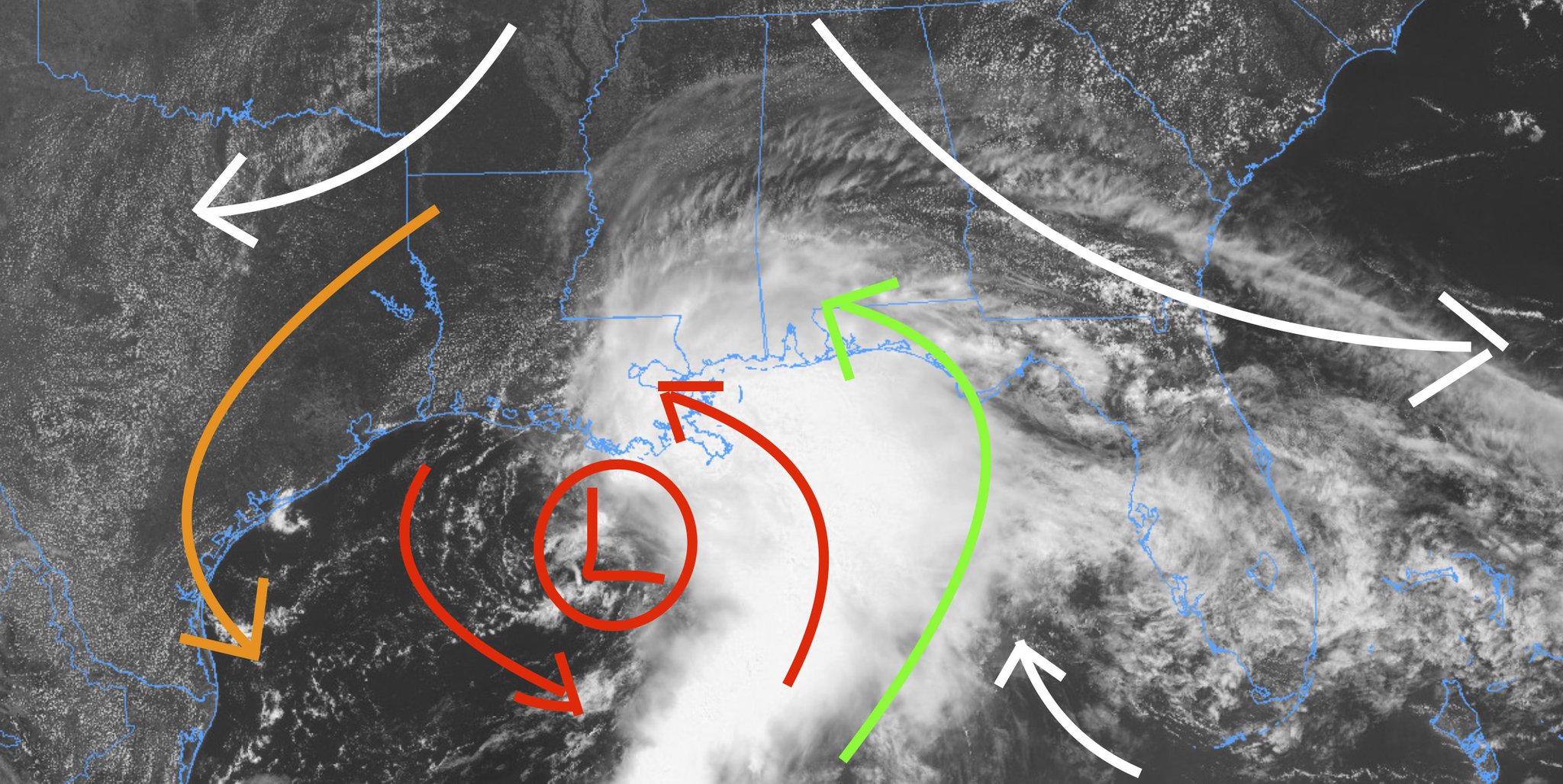
In the above image the white arrows indicate the general atmospheric flow, the red arrows indicate the circulation around the central area of low pressure. The brown arrows shows the dry air leaking down and into the area of circulation. The green arrows show the warm moist air being pulled up from the Caribbean.
The last update from the NHC showed landfall south of New Orleans followed by a turn to the northeast and then eventually to the east.
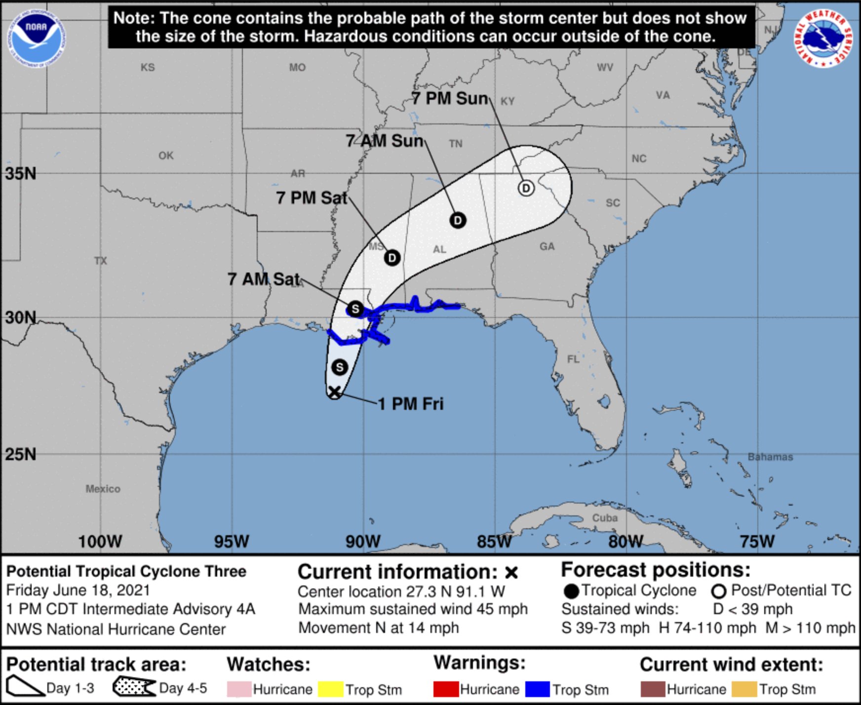
This type of track would drench parts of Louisiana, Mississippi and Alabama during the next 36 hours. Looking at the rainfall totals during the next 48 hours across many of the different models, you can see that each model shows a streak of highest totals in different areas.
This still doesn’t look like a “wind” or “surge” storm. This is going to be quite the rainmaker – especially along the coast. The WPC has a Moderate Risk out for flash flooding for the area. And the SPC has the area pegged with a Marginal Risk for wind gusts up to 60mph and brief tropical tornadoes.
TIMELINE
3p – 9p || Increasing clouds with showers and tropical storms possible. Generally still calm with gusty wind to 20mph.
9p – 3a || Passing showers and tropical storms. This is when the flash flooding risk and the brief tornado threat will be the highest. This is also when wind gusts will be around 30-40mph.
3a – 9a || Passing showers continue, particularly before dawn. Flash flooding risk continues, but the tornado threat starts to diminish. Sustained wind around 15mph
9a – 3p || Clearing skies, though still breezy with sustained wind around 10-15mph.
THREATS
This is still a rainmaker as the main concern. Even the threat for tornadoes is still lower than the threat for flash flooding. In other words, the risk of your home being damaged by flooding rains is higher than your home being damaged by a tornado.
Tornadoes will be most likely through the overnight hours, but again, these will be brief and generally weak. These aren’t the kind of tornadoes that tear homes off their foundations. These tend to do a lot of tree damage and roof damage.
County-by-county timeline breakdown
I will try to break things down county-by-county here. Generally the overall forecast is the same across our area with only tiny wrinkles here and there. In general, the greatest concern is for 2″ to 6″ of rain across the area. But the gradient from Northwest to Southeast may be pretty sharp.
Northern counties
Simpson County
Friday PM – Increasing clouds with a few showers, especially starting around midnight. Up to 1/2″ of rain from any passing tropical shower or storm. Wind gusts up to 20mph possible
Saturday AM – Scattered tropical showers. Wind gusts up to 35mph possible. Up to 1″ of rain from any passing tropical shower or storm.
Saturday PM – Clearing skies. Still breezy with gusts to 20mph. A stray shower possible.
Smith County
Friday PM – Increasing clouds with a few showers, especially starting around midnight. Up to 1/2″ of rain from any passing tropical shower or storm. Wind gusts up to 20mph possible
Saturday AM – Scattered tropical showers. Wind gusts up to 35mph possible. Up to 1″ of rain from any passing tropical shower or storm.
Saturday PM – Clearing skies. Still breezy with gusts to 20mph. A stray shower possible.
Jasper County
Friday PM – Increasing clouds with a few showers, especially starting around midnight. Up to 1/2″ of rain from any passing tropical shower or storm. Wind gusts up to 20mph possible
Saturday AM – Scattered tropical showers. Wind gusts up to 35mph possible. Up to 1″ of rain from any passing tropical shower or storm.
Saturday PM – Clearing skies. Still breezy with gusts to 20mph. A stray shower possible.
Clarke County
Friday PM – Increasing clouds with a few showers, especially starting around midnight. Up to 1″ of rain from any passing tropical shower or storm. Wind gusts up to 20mph possible
Saturday AM – Scattered tropical showers. Wind gusts up to 35mph possible. Up to 1″ of rain from any passing tropical shower or storm.
Saturday PM – Clearing skies. Still breezy with gusts to 20mph. A stray shower possible.
The Highway 84 Corridor
Lawrence County
Friday PM – Increasing clouds with a few showers, especially starting around midnight. Up to 1/2″ of rain from any passing tropical shower or storm. Wind gusts up to 20mph possible
Saturday AM – Scattered tropical showers. Wind gusts up to 35mph possible. Up to 1″ of rain from any passing tropical shower or storm.
Saturday PM – Clearing skies. Still breezy with gusts to 20mph. A stray shower possible.
Jeff Davis County
Friday PM – Increasing clouds with a few showers, especially starting around midnight. Up to 1/2″ of rain from any passing tropical shower or storm. Wind gusts up to 20mph possible
Saturday AM – Scattered tropical showers. Wind gusts up to 35mph possible. Up to 1″ of rain from any passing tropical shower or storm.
Saturday PM – Clearing skies. Still breezy with gusts to 20mph. A stray shower possible.
Covington County
Friday PM – Increasing clouds with a few showers, especially starting around midnight. Up to 1″ of rain from any passing tropical shower or storm. Wind gusts up to 20mph possible
Saturday AM – Scattered tropical showers. Wind gusts up to 35mph possible. Up to 1″ of rain from any passing tropical shower or storm.
Saturday PM – Clearing skies. Still breezy with gusts to 20mph. A stray shower possible.
Jones County
Friday PM – Increasing clouds with a few showers, especially starting around midnight. Up to 1″ of rain from any passing tropical shower or storm. Wind gusts up to 20mph possible
Saturday AM – Scattered tropical showers. Wind gusts up to 35mph possible. Up to 1″ of rain from any passing tropical shower or storm.
Saturday PM – Clearing skies. Still breezy with gusts to 20mph. A stray shower possible.
Wayne County
Friday PM – Increasing clouds with a few showers, especially starting around midnight. Up to 1″ of rain from any passing tropical shower or storm. Wind gusts up to 20mph possible
Saturday AM – Scattered tropical showers. Wind gusts up to 40mph possible. Up to 1″ of rain from any passing tropical shower or storm.
Saturday PM n- Clearing skies. Still breezy with gusts to 20mph. A stray shower possible.
The Highway 98 Corridor
Walthall County
Friday PM – Increasing clouds with a few showers, especially starting around midnight. Up to 1/2″ of rain from any passing tropical shower or storm. Wind gusts up to 20mph possible
Saturday AM – Scattered tropical showers. Wind gusts up to 35mph possible. Up to 1″ of rain from any passing tropical shower or storm.
Saturday PM – Clearing skies. Still breezy with gusts to 20mph. A stray shower possible.
Marion County
Friday PM – Increasing clouds with a few showers, especially starting around midnight. Up to 1/2″ of rain from any passing tropical shower or storm. Wind gusts up to 20mph possible
Saturday AM – Scattered tropical showers. Wind gusts up to 35mph possible. Up to 1″ of rain from any passing tropical shower or storm.
Saturday PM – Clearing skies. Still breezy with gusts to 20mph. A stray shower possible.
Lamar County
Friday PM – Increasing clouds with a few showers, especially starting around midnight. Up to 1″ of rain from any passing tropical shower or storm. Wind gusts up to 20mph possible
Saturday AM – Scattered tropical showers. Wind gusts up to 35mph possible. Up to 1″ of rain from any passing tropical shower or storm.
Saturday PM – Clearing skies. Still breezy with gusts to 20mph. A stray shower possible.
Forrest County
Friday PM – Increasing clouds with a few showers, especially starting around midnight. Up to 1″ of rain from any passing tropical shower or storm. Wind gusts up to 20mph possible
Saturday AM – Scattered tropical showers. Brief tropical tornadoes possible. Wind gusts up to 35mph possible. Up to 1″ of rain from any passing tropical shower or storm. Up tp 3″ in total during this time.
Saturday PM – Clearing skies. Still breezy with gusts to 20mph. A stray shower possible.
Perry County
Friday PM – Increasing clouds with a few showers, especially starting around midnight. Up to 1″ of rain from any passing tropical shower or storm. Wind gusts up to 20mph possible
Saturday AM – Scattered tropical showers. Brief tropical tornadoes possible. Wind gusts up to 35mph possible. Up to 1″ of rain from any passing tropical shower or storm. Up tp 3″ in total during this time.
Saturday PM – Clearing skies. Still breezy with gusts to 20mph. A stray shower possible.
Greene County
Friday PM – Increasing clouds with a few showers, especially starting around midnight. Up to 1″ of rain from any passing tropical shower or storm. Wind gusts up to 20mph possible
Saturday AM – Scattered tropical showers. Brief tropical tornadoes possible. Wind gusts up to 35mph possible. Up to 1″ of rain from any passing tropical shower or storm. Up tp 5″ in total during this time.
Saturday PM – Clearing skies. Still breezy with gusts to 20mph. A stray shower possible.
The Highway 26 Corridor
Pearl River County
Friday PM – Increasing clouds with a few showers, especially starting around midnight. Up to 1″ of rain from any passing tropical shower or storm. Wind gusts up to 20mph possible
Saturday AM – Scattered tropical showers. Brief tropical tornadoes possible. Wind gusts up to 35mph possible. Up to 1″ of rain from any passing tropical shower or storm. Up tp 3″ in total during this time.
Saturday PM – Clearing skies. Still breezy with gusts to 20mph. A stray shower possible.
Stone County
Friday PM – Increasing clouds with a few showers, especially starting around midnight. Up to 1″ of rain from any passing tropical shower or storm. Wind gusts up to 20mph possible
Saturday AM – Scattered tropical showers. Brief tropical tornadoes possible. Wind gusts up to 35mph possible. Up to 1″ of rain from any passing tropical shower or storm. Up tp 5″ in total during this time.
Saturday PM – Clearing skies. Still breezy with gusts to 20mph. A stray shower possible.
George County
Friday PM – Increasing clouds with a few showers, especially starting around midnight. Up to 1″ of rain from any passing tropical shower or storm. Wind gusts up to 20mph possible
Saturday AM – Scattered tropical showers. Brief tropical tornadoes possible. Wind gusts up to 35mph possible. Up to 1″ of rain from any passing tropical shower or storm. Up tp 6″ in total during this time.
Saturday PM – Clearing skies. Still breezy with gusts to 20mph. A stray shower possible.
.


Thanks Nick for a county by county forecast for the upcoming tropical system for South Mississippi. We have a small gathering tomorrow and this is just what we needed to make final plans. Thank you!
Thanks for the update and a BIG thank you for the county-by-county update!! I know it takes quite a bit of time to put this out and it is GREATLY appreciated!!
I guess, instead of Claudette, we’ll name this storm Blondie … you know, the storm with no name!
Thanks Nick. You are awesome. You are missed!!!!