And no, I’m not exaggerating, it’s going to be a hot several days out there!
The Large Scale
At the synoptic scale, a fairly strong upper level ridge resides over Texas and northern Mexico. Looking at the video above, the ridge is essentially like a boulder on flat ground and will slowly be moved towards the southeast before dissolving around the end of next weekend with the California trough moving east and possibly even some Pacific tropical influence.
The upper-level ridge position will bring winds from the northeast in the upper levels which will inhibit some storm development for the next couple of days, however, the surface ridge position over the Gulf of Mexico will send more southerly winds which will keep us hot and muggy for the next several days.

This Weekend
Expect our usual hot and humid weather but with more limited storm development. Most of the storms on Saturday will be towards south Louisiana with a few creeping into portions of Southwestern Mississippi, but isolated thunderstorms can’t be ruled out.
Sunday will be much hotter with heat indices reaching into the 100s, but rain will be possible into the late evening into the early morning hours. With the aforementioned upper level ridging and the northwestern influence overhead, these storms will come in from the north and strengthen over Tennessee and northern Mississippi before weakening closer to central Mississippi and Alabama.
With higher dewpoints and CAPE values, it would not be surprising to see some of these storms to possibly become severe especially in areas of north and central Mississippi during the evening hours. Flash flooding, some hail, wind, and lightning would be associated with this line.

Next Week
While the ridge settles in, some early morning rain will be possible on Monday, but the heat will begin to build as the day goes on. Tuesday may also see a chance of storms in the overnight hours that will come from the northwest. These storms look to strengthen closer to the coast in the early morning.
Tuesday onward past the weekend is where the dangerous heat steps in. Rain chances will begin to diminish with a few closer to the coastline, however, Wednesday may also have a chance for thunderstorms with another shortwave ridge pushing from the north. Rain chances will move further east closer to the weekend as the Texas ridge begins to move our direction.
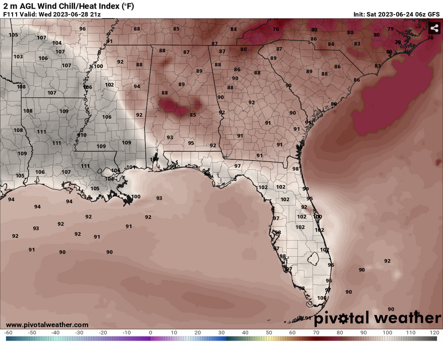
It’s worth repeating, this heat is going to be dangerous. If outside, wear a hat to shade yourself, bring water, an electrolyte drink, and take frequent breaks. The heat indices will be reaching into the 110s by the end of the week into the weekend and there won’t be a lot of relief since this ridge will inhibit a lot of wind and rain.
The weekend will see a couple of possible rain chances in the overnight hours especially on Sunday when the ridge begins to break down. We may see a more active weather pattern starting the week after with a trough moving in.
[wpcode id=”41179″]
Regional Day-to-Day Forecast
Today – Mostly sunny, with a high near 95. South southeast wind around 5 mph becoming west southwest in the afternoon.
Tonight – Mostly clear, with a low around 74. South wind around 5 mph becoming calm after midnight.
Sunday – A 20 percent chance of showers and thunderstorms after 1pm. Sunny, with a high near 95. Heat index values as high as 105. Light southwest wind becoming west southwest 5 to 10 mph in the morning.
Sunday Night – Partly cloudy, with a low around 76. Rain possible overnight with some strong storms possible. South wind around 5 mph.
Monday – A 30 percent chance of showers and thunderstorms in the afternoon. Mostly sunny, with a high near 95. Light west southwest wind becoming west 5 to 10 mph in the morning. Winds could gust as high as 20 mph.
Monday Night – A chance of showers and thunderstorms overnight. Mostly clear, with a low around 77. West wind around 5 mph becoming calm in the evening.
Tuesday – A 30 percent chance of showers and thunderstorms in the afternoon. Sunny and hot, with a high near 98. Calm wind becoming west northwest around 5 mph in the afternoon. Winds could gust as high as 20 mph.
Tuesday Night – Mostly clear, with a low around 74. North northeast wind around 5 mph becoming calm in the evening.
Wednesday – A 20 percent chance of showers and thunderstorms after 1pm. Sunny and hot, with a high near 98. Calm wind becoming west around 5 mph in the afternoon.
Wednesday Night – Mostly clear, with a low around 76.
Thursday – Sunny and hot, with a high near 101.
Thursday Night – Mostly clear, with a low around 77.
Friday – Mostly sunny and hot, with a high near 99.
[wpcode id=”41149″]


