
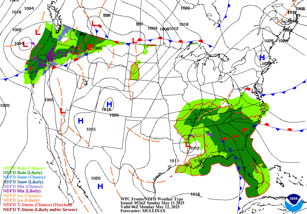
Significant Threat of Severe Weather in the Northeast
Heavy rain and severe weather will be flourishing along the cold front sweeping across the the northern half of the country. Ahead of the cold front will be strong lifting that will be the instigator responsible for much of rain. All across the southern New England area extending down through the Mid Atlantic to Virginia will be under the threat of possible thunderstorms, intense winds, and even slight chances of hail. Intense daytime heating ahead of the cold front along with cooler mid-level temperatures will create strong CAPE values. Virginia is looking to be the most at risk in the Eastern half of the US where the atmosphere will be the most unstable.
Strong shear values will prevent from majorly intense storms from forming. Further north, these CAPE and shear values will less intense due to limited surface heating from early morning cloud coverage but the approaching cold front however will still allow for heavy rain nonetheless all throughout the day. The strongest of these storms will be around the mid-afternoon into the evening.
Meanwhile, weather out in the Midwestern region will be less certain in terms of severity as a localized mesoscale vortex (MCV) will be moving in the Nebraska / South Dakota border. Much of the possible severe weather will form along the outflow boundary of this approaching MCV. However, general model agreement is spotty at this moment in terms of exact timing and location. Despite this, conditions will still remain favorably for hail and intense winds.
High Temperatures Cooling Off in the East


The heatwave across the most of the Eastern US lessen a bit around the Great Lakes region into New England. As the upper-level ridge over the Southwest US weakens, the trough out East will also begin to amplify again early into next week. This ridge will propagate west past Texas, allowing for extremely high temperatures into the 100s in the Southern Great Plains region into the Southeast coastal area. High temperatures further north in the Midwest will still be relatively high with most places experiencing 90 degree weather. Meanwhile the rest of the country will be ex
Extended Outlook


Looking further ahead into the next couple weeks, general temperature trends will continue with the Southeast US expecting above average temperatures extending up along the Western coast. As our upper-level pattern shift back west, excessive heat will once again flourish in the Southwest while the Northeast and Central US will likely be cooler for the time being.
Conclusion
Heavy rain and the main threat of severe will be affecting the Northeast all throughout the day but gradually intensifying as surface heating increases, enhancing convection for the possible threat of hail and strong wind. Conditions out west will be less certain but still likely for hail and intense rain to pop up throughout the day. High pressure further south will keep the area relatively hot and dry for the remaining period.


