A Beautiful Weekend with Some Clouds to Interrupt Your Eclipse Viewing – Weekend Forecast 4/6/24

We’re going into our second month of Spring and so far, the past couple of weekends have been absolutely gorgeous for being outside. Temperatures are topping out around the mid and upper 70s and even the low 80s with a few clouds in the sky. This weekend will be a great time to take care of yard work, go for a picnic, or just go for a walk.
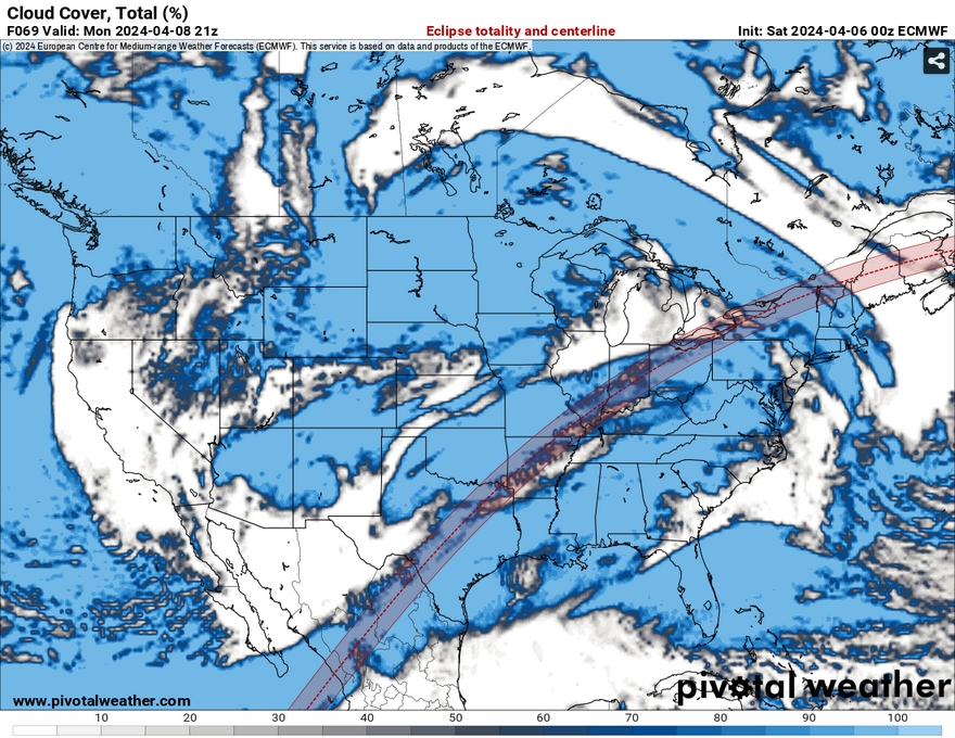
Cloud cover and the eclipse path from the Euro model //Courtesy: Pivotal Weather

Now, I know many of you have been asking about the eclipse and Nick talked about it in yesterday’s blog. Many areas on Monday will have some higher clouds to contend with to watch the eclipse in our neck of the woods. We’ll even have a few low clouds as the storm system is setting up to our west and northwest. Many areas in the direct path of the eclipse, namely Texas and Arkansas, will have to deal with the low pressure system bringing some stout rain and possible severe weather on Monday into Tuesday.
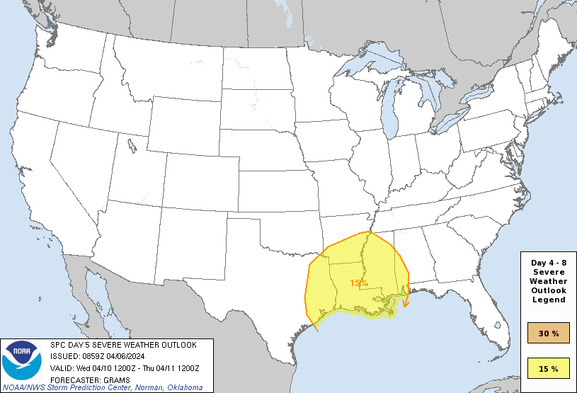
Storm Probability from the Storm Prediction Center

I won’t go into too much detail about the severe weather Tuesday into Wednesday since I’m going to cover that tomorrow, but there are a few things I noticed looking at the Skew-T’s. First of all, the amount of precipitable water from this system is high, around 2 inches. What this will likely mean is we’ll see a lot of rain and some possible flash flooding. Couple this with the occluding front stalling over us for a few days, we’ll have a lot of rain to deal with until this thing finally leaves near the end of the week.

Until then, enjoy your weekend! We have beautiful weather ahead and hopefully an eclipse to watch at the beginning of the week!


[wpcode id=”41179″=


Regional Day-to-Day Forecast

Today – Mostly sunny, with a high in the upper 70s. East southeast wind around 5 mph.

Tonight – Partly cloudy, with a low in the mid 50s. East southeast wind around 5 mph becoming calm in the evening.

Sunday – Mostly sunny, with a high in the low 80s. South wind 5 to 10 mph, with gusts as high as 20 mph.

Sunday Night – Mostly cloudy, with a low around 60. South wind 5 to 10 mph, with gusts as high as 20 mph.

Monday – A slight chance of showers, then a chance of showers and thunderstorms in the afternoon. Mostly cloudy, with a high near 80. South southeast wind 5 to 10 mph, with gusts as high as 20 mph. Chance of precipitation is 30%.

Monday Night – A 30 percent chance of showers and thunderstorms, mainly before midnight. Mostly cloudy, with a low in the low 60s. South southeast wind around 10 mph, with gusts as high as 25 mph.

Tuesday – A 20 percent chance of showers and thunderstorms in the afternoon. Mostly cloudy, with a high in the low 80s. Southeast wind 10 to 15 mph, with gusts as high as 25 mph.

Tuesday Night – A 40 percent chance of showers and thunderstorms, mainly after midnight. Mostly cloudy, with a low in the mid 60s. Southeast wind around 15 mph, with gusts as high as 25 mph.

Wednesday – Showers and possibly a thunderstorm. Some of the storms could be severe and produce heavy rainfall. High in the mid 70s. Southeast wind 10 to 15 mph, with gusts as high as 30 mph. Chance of precipitation is 80%.

Wednesday Night – A 50 percent chance of showers and thunderstorms. Some of the storms could be severe. Mostly cloudy, with a low in the upper 50s.

Thursday – A 20 percent chance of showers. Partly sunny, with a high in the mid 70s.

Thursday Night – Partly cloudy, with a low in the low 50s.

Friday – Sunny, with a high in the mid 70s.

[wpcode id=”41149″]


Author of the article:


Noah Gower

Meteorologist residing in Hattiesburg, MS. Mississippi State University alumni with a passion for climatology, forecasting, and mapping. Loves skateboarding, bass guitar/music, and a good motorcycle ride. Currently working as an Engineering Technician.