Buckle up! We’re in a rollercoaster pattern, or more formally known as a quasi-omega block, where a strong area of high pressure is sandwiched between two low-pressure systems. Southerly flow is pumping warm, moist Gulf air into our region. For us, being in close proximity to a trough, we can expect high chances for scattered showers/thunderstorms tomorrow and Friday.
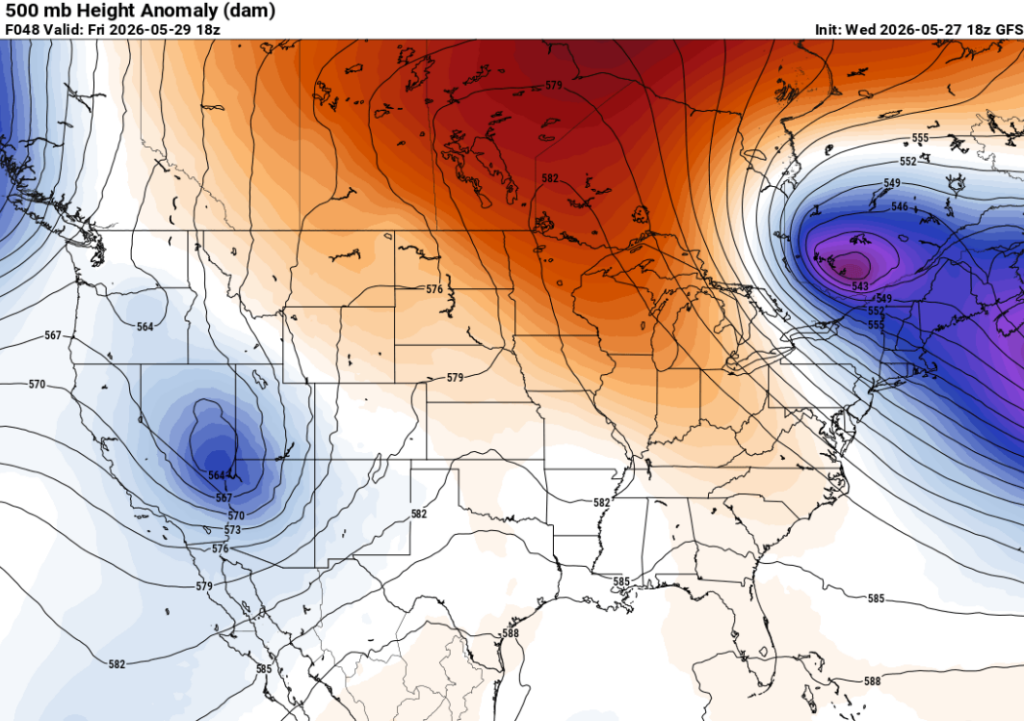
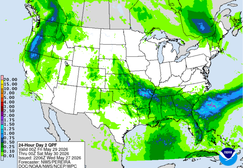
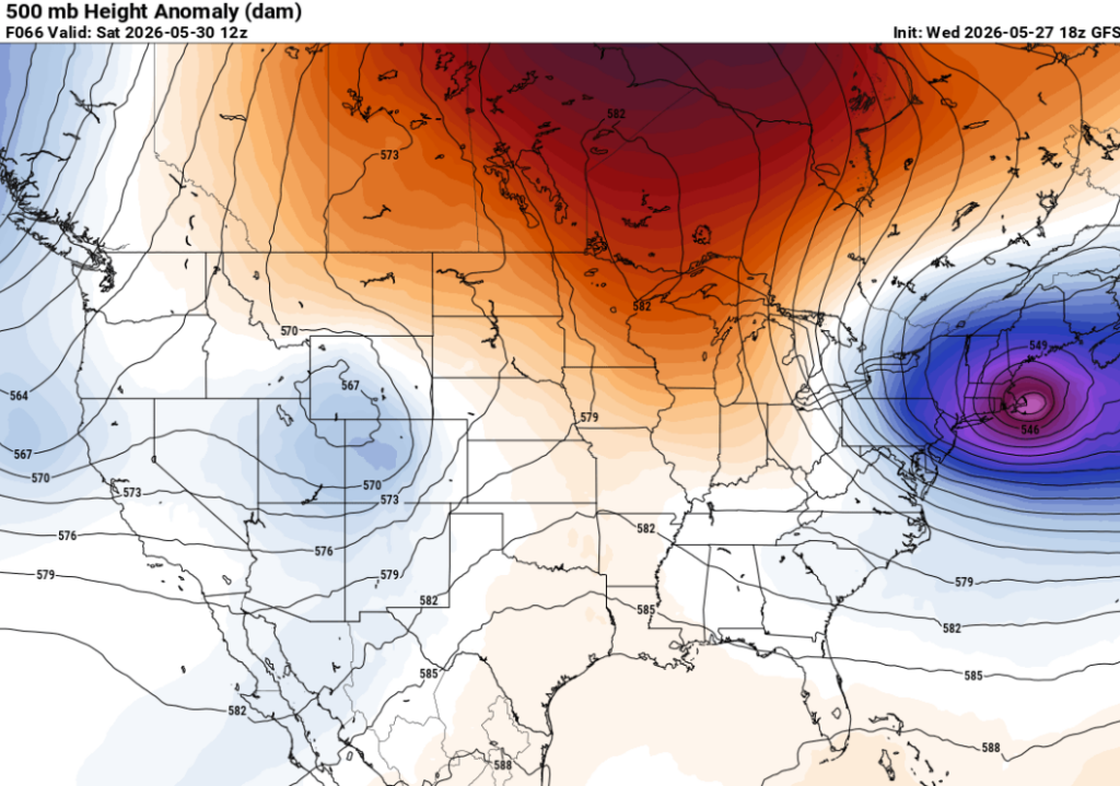
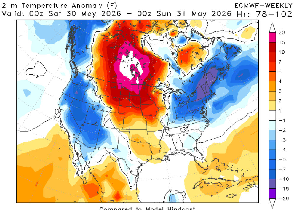
This weekend, we’ll see a slight change in the pattern. The upper low will lift out, and the flow will become more zonal in our region. A weak ridge builds in, and for us, this will help divert Gulf moisture away from the area, lowering rain chances a bit this weekend. Temperatures will range from normal to above normal.
3-DAY TRAVEL FORECAST
Airports
KIAH / KHOU (Houston) – Watch for patchy fog Thursday morning. Slight chance of showers and thunderstorms on Thursday, mainly after 4pm. Marginal excessive rainfall risk Thursday. Lightning could delay flights and watch for minor ponding on roads.
KSHV (Shreveport) – Showers/thunderstorms Thursday morning through the afternoon, along with a marginal excessive rainfall risk on Thursday. Low chance of isolated thunderstorms Friday afternoon. Lightning could delay flights and watch for minor ponding on roads.
KBTR (Baton Rouge) – Showers and storms possible each day, along with a marginal excessive rainfall risk on Thursday. Lightning could delay flights and watch for minor ponding on roads.
KMSY (New Orleans) – Afternoon showers and storms possible each day, along with a marginal excessive rainfall risk on Thursday. Some intermittent flight delays are possible for lightning. Watch roadways for ponding and keep watch for flash flooding.
KJAN (Jackson) – Showers and storms possible each day, along with a marginal excessive rainfall risk on Thursday and Friday. Lightning could delay flights and watch for minor flooding on roads.
KMOB (Mobile) – Showers and storms possible each day, along with a marginal excessive rainfall risk on Thursday and Friday. Lightning could delay flights and watch for minor flooding on roads.
KBMH (Birmingham) – Afternoon showers and storms possible each day, along with a marginal excessive rainfall risk on Thursday and Friday. Watch for patchy fog in the mornings. Some intermittent flight delays are possible for lightning. Watch roadways for ponding and flash flooding.
KTLH (Tallahassee) – Afternoon showers and storms possible each day. Watch for patchy fog Thursday morning. Lightning could delay flights.
KATL (Atlanta) – Showers and storms possible each day. Highest chances for afternoon storms on Friday. Intermittent weather delays possible for some flights due to lightning. Marginal excessive rainfall risk Thursday-Saturday, watch for minor flooding and ponding on roadways. Watch for patchy fog Thursday morning.
Highways
I-10
Scattered thunderstorms are expected to develop Thursday afternoon along I-10 and should move out by sunset. On Friday, the heaviest precipitation will be east of Mobile. Brief heavy rain, lightning, and ponding on roads possible at times.
I-20
Thursday afternoon storms, along with scattered early-morning thunderstorms Friday west of Atlanta, could impact travel. Locally heavy downpours may briefly slow travel. A few additional shower chances return again on Saturday.
I-49
An early-morning round of rain on Thursday could impact travel, especially near Baton Rouge. There is also a slight chance of showers and thunderstorms on both Friday and Saturday. Use extra caution on the roads.
I-55 & I-59
Scattered storms are expected throughout Thursday, mainly across southern Mississippi. Be careful during any downpours, as brief heavy rain could reduce visibility and make roads slick. By Friday evening, additional showers and storms are possible near Jackson.
I-65
Scattered showers and storms are expected Thursday. Friday afternoon thunderstorms may develop across southern and central Alabama. By Saturday, showers will mainly be in northern Alabama. A marginal risk of excessive rainfall is in place, so watch for ponding water on roads during heavier downpours.
I-75
Thursday morning thunderstorms across northern Florida and southern Georgia could impact travel, with locally heavy downpours. By the afternoon, scattered storms will develop across central Georgia and continue through the day. High chances of thunderstorms on Friday, with potential for ponding water and minor flooding. Saturday brings more widespread showers across the region.
CITY FORECASTS
Houston, TX
Thursday– Watch for patchy fog in the morning. Slight chance of showers and thunderstorms, mainly after 4pm. Marginal excessive rainfall risk, watch for ponding on roads. Otherwise, mostly sunny, high near 89. Northeast wind around 5mph.
Friday– Mostly sunny, with a high near 91. Calm southerly wind.
Saturday– Mostly sunny, with a high near 90. Calm southerly wind.
Shreveport, LA
Thursday– Low chance of showers/thunderstorms in the early morning and afternoon hours, along with a marginal excessive rainfall risk. Gradually becoming sunny, with a high near 87. Light northwest wind.
Friday– Low chance of isolated thunderstorms Friday afternoon. Mostly sunny, with highs nearing 90. Light westerly wind.
Saturday– Mostly sunny, with a high near 91.
Baton Rouge, LA
Thursday– Chance of showers and thunderstorms all day, highest chances between 1-4. Otherwise, cloudy, with a high near 85. Calm southerly wind.
Friday– Slight chance of showers and thunderstorms in the afternoon. Mostly sunny, with a high near 87. Light southwest winds.
Saturday– Low chance of showers and thunderstorms in the afternoon. Otherwise, mostly sunny, with a high near 88. Light wind from the west.
New Orleans, LA
Thursday– Chance of showers and thunderstorms all day, highest chances between 1-3. Some of the storms could produce heavy rainfall. High near 84. Calm south wind.
Friday– Chance of showers and thunderstorms all day. Partly sunny, with a high near 84. Calm southwest wind.
Saturday– Low chance of showers and thunderstorms in the afternoon. Otherwise, mostly sunny, with a high near 88. Light wind from the west.
Jackson, MS
Thursday– High chance of showers and thunderstorms, mainly before 5pm. High near 86. Southwest wind 5 to 9 mph.
Friday– High chance of showers and thunderstorms all day. High near 86. Light winds blowing from the north.
Saturday– High chance of showers and thunderstorms all day. High near 85.
Birmingham, AL
Thursday– Showers and thunderstorms, mainly after 1pm. Patchy fog before 9am. Otherwise, cloudy, with a high near 84. Calm wind.
Friday– Showers and possibly a thunderstorm, highest chances in the evening. Patchy fog before 8am. High near 83. Light southwesterly wind.
Saturday – Showers and possibly a thunderstorm, highest chances between 1-7. High near 83 with light winds blowing from the north.
Mobile, AL
Thursday– High chance of showers and thunderstorms all day. High near 84. Calm southerly wind.
Friday– High chance of showers and thunderstorms all day. High near 87. Calm southerly wind.
Saturday– Chance of showers and thunderstorms all day, highest chances between 1-3. High near 87. Light wind blowing from the west.
Tallahassee, FL
Thursday– Showers and thunderstorms likely, mainly between 2pm and 5pm. Patchy fog before 8am. High near 84. Light southwest wind.
Friday– Moderate chances of showers and thunderstorms, mainly between 2pm and 5pm. High near 87. Light southwest wind.
Saturday– Showers and thunderstorms likely, mainly between 2pm and 5pm. High near 85. Light winds blowing from the west.
Atlanta, GA
Thursday– Patchy fog in the morning. Slight chance for some scattered storms in the afternoon and evening hours. Otherwise, mostly sunny, with a high near 84. Calm wind from the northwest.
Friday– High chance of showers and thunderstorms, mostly after 2 pm. High near 79. East wind 5 to 10 mph, with gusts as high as 15 mph.
Saturday– Showers, with thunderstorms also possible after 11am. High near 80. Light winds blowing from the north.


