As I’m writing this, temperatures are in the low to mid 80s around our area, with dew points in the low 70s. Cloud cover is relatively sparse, so conditions are ideal for the development of widespread weak thunderstorms this afternoon.
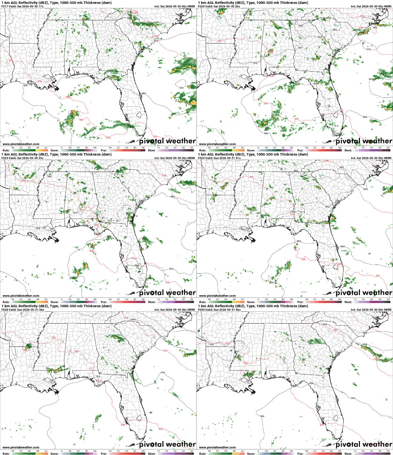
Weak thunderstorms will develop later this afternoon over Mississippi and Alabama, bringing gusty winds, heavy rains, and lightning. There have also been several consecutive runs of the HRRR showing a squall line forming around 6 tonight slightly to the east of Jackson near Bay Springs making its way down to Hattiesburg by 10. Localized storms may produce up to 2-3″ of rain.
Later This Week
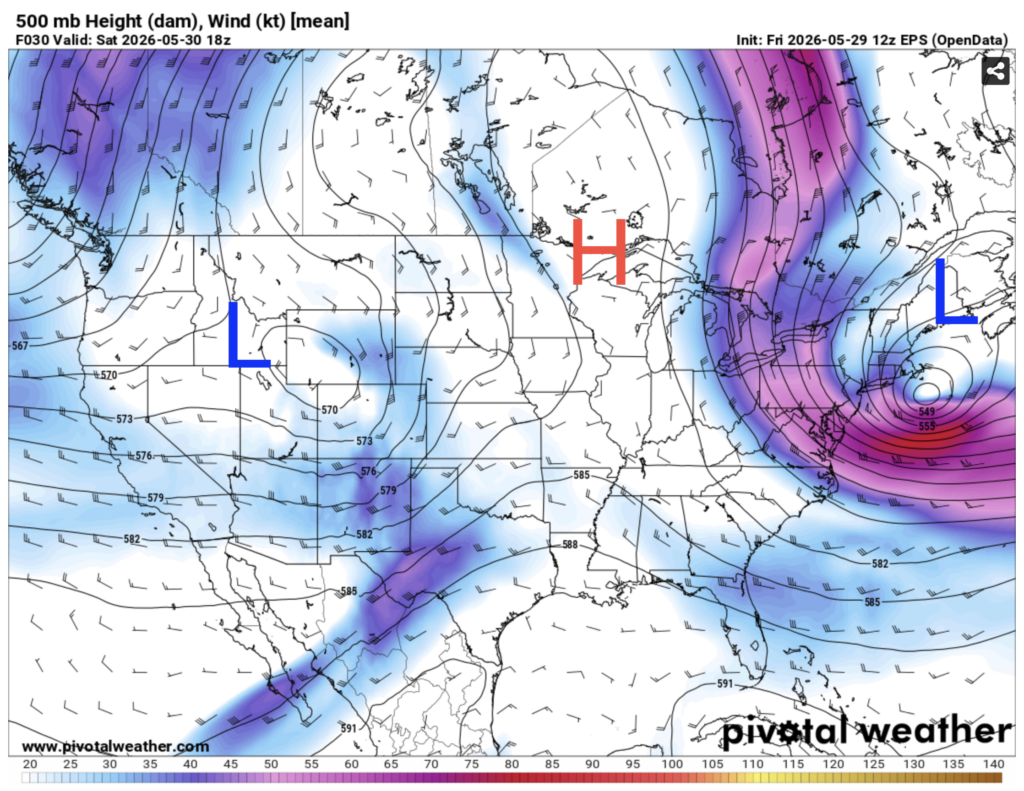
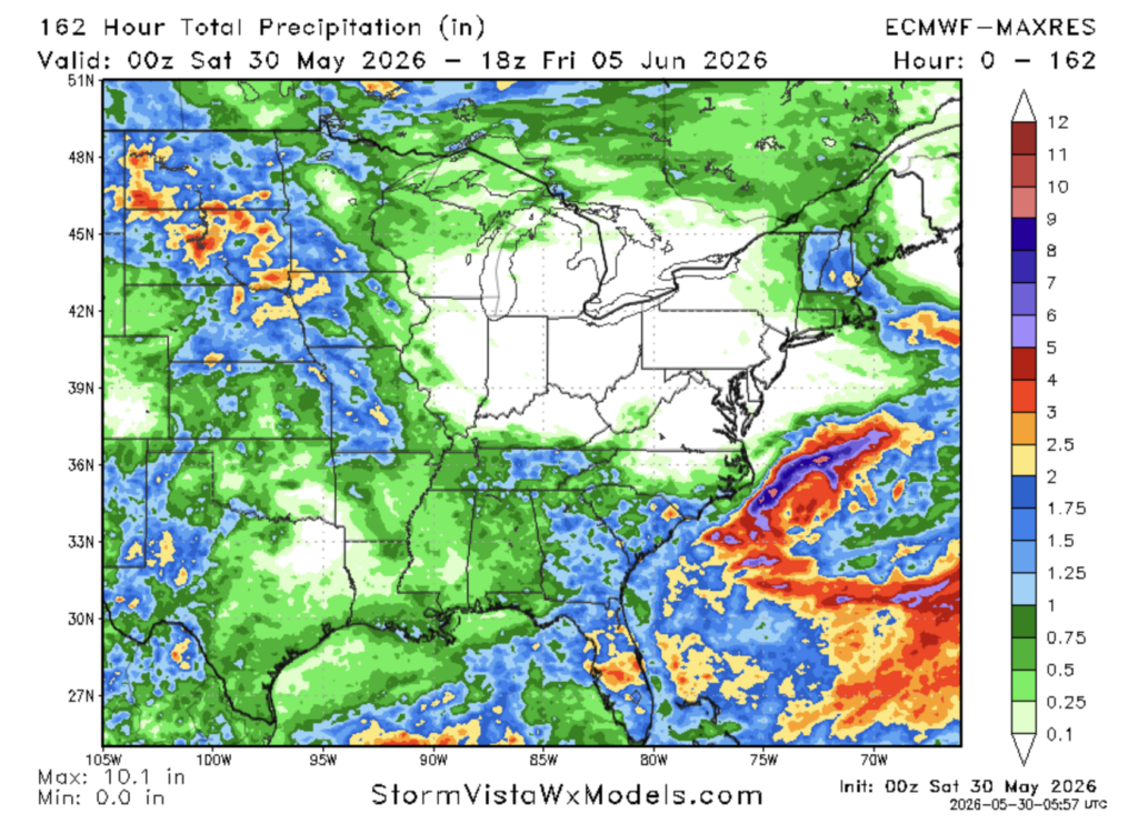
For the past few days we’ve been stuck in an omega block pattern. This is when there are two areas of low pressure, one in the west, and one in the northeast, and an area of high pressure in the central U.S. It’s called an omega block pattern because the jet stream is shaped like the Greek letter omega (Ω).
This pattern has brought us daily storms as the wind coming out of the south is drawing up that humid gulf air that’s perfect for thunderstorms. Luckily, these storms have been pretty weak, so we haven’t gotten too soaked over the past couple days. We’re stuck in this pattern until around Wednesday.
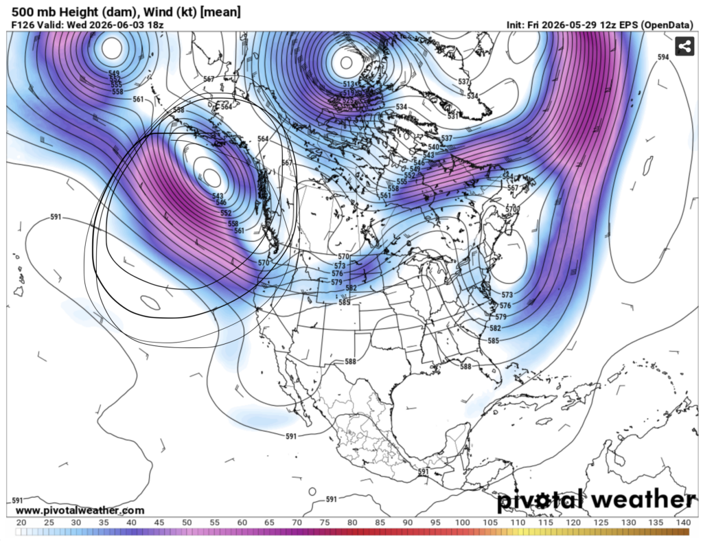
On Wednesday, a ridge of high pressure will begin to build over our area. Usually, when you think of high pressure you think of hot conditions. That is not the case this week, as the air is actually re-circulated air from the gulf of Alaska (circled region). As it moves over land, this air will dry out, giving us a nice break from the humidity.
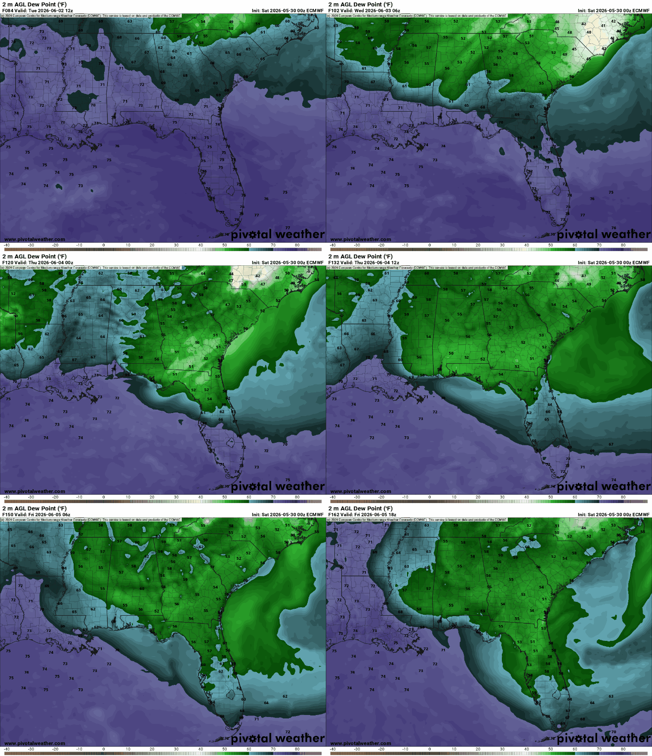
Wooooooosh… that’s more like it!
Airport Forecast
KHOU/KIAH (Houston) – Current: temperature is around 88ºF, sunny skies, southerly wind of 5 mph, dew point of 72ºF, visibility of 26 miles. Tonight: high will get up to 92ºF, cloudy conditions will increase as time goes on, but no rain is expected. No delays or cancellations due to weather are likely.
KATL (Atlanta) – Current: temperature is 82ºF, isolated weak storms are located to the south and west, westerly wind of 3 mph, dew point of 68ºF, visibility of 11 miles. Tonight: high will get up to 81ºF, a weak thunderstorm or two is possible, but rain totals won’t be excessive. Minor delays possible.
KMSY (New Orleans) – Current: temperature is 86ºF, skies are sunny with a few clouds, southwesterly wind of 3 mph, dew point of 71ºF, visibility of 12 miles. Tonight: high will get up to 89ºF, very light showers are possible this afternoon and evening. No delays or cancellations are expected.
KBTR (Baton Rouge) – Current: temperature is 87ºF, skies are mostly sunny with a few clouds, southwesterly wind of 4 mph, dew point of 72ºF, visibility of 6 miles. Tonight: high will get up to 89ºF, very light showers possible this afternoon going into the evening. No delays or cancellations are expected.
KSHV (Shreveport) – Current: temperature is 91ºF, skies are sunny, southwesterly wind of 1 mph, dew point of 71ºF, visibility of 26 miles. Tonight: high will get up to 94ºF, no rain is expected. Shreveport is currently under an excessive heat warning. No delays or cancellations are expected.
KJAN (Jackson) – Current: temperature is 86ºF, skies are partly cloudy, northwesterly winds of 6 mph, dew point of 71ºF, visibility of 7 miles. Tonight: high will get up to 87ºF, an isolated thunderstorm or two is possible. Minor delays are possible.
KBHM (Birmingham) – Current: temperature is 82ºF, skies are mostly cloudy, northwesterly winds of 7 mph, dew point of 71ºF, visibility of 10 miles. Tonight: high will get up to 84ºF, light showers and thunderstorms will produce light rain accumulations. Minor delays are possible.
KMOB (Mobile) – Current: temperature is 88ºF, skies are partly cloudy, wind is 5 mph and shifting direction, dew point of 72ºF, visibility of 10 miles. Tonight: high will get up to 89ºF, light showers and thunderstorms will produce some light rain accumulations. Minor delays are possible.
KTLH (Tallahassee) – Current: temperature is 87ºF, skies are partly cloudy, storms are to the north, wind is southwesterly at 14 mph, visibility of 10 miles. Tonight: high will get up to 89ºF. Isolated storms will move through the area twice: once in the early afternoon, and once later this evening. Localized rain accumulations may be up to 1.5″. Minor delays and cancellations are possible.
Highway Forecast
I-10: Greatest chance of pop-up storms moving south near the Florida panhandle and coastal Alabama. Most of the storm threat will be gone by 8-9 pm, except for southern Mississippi, which may see a line of storms pass through the area closer to 10-11 pm.
I-20: Pop up storm threat is greatest in Alabama and Georgia, but will be mostly isolated thunderstorms. Most storms will be out of the area by 8 pm.
I-49: Small chance for some isolated showers and thunderstorms, overall good driving conditions. Pop up storms most likely to the east of the interstate, near Springhill, LA. No significant chance of storms further south.
I-55: Moderate chance for isolated pop up storms. Greatest chance in south-central Mississippi, with a line of storms rolling through the area between 6 and 11 pm. However, these storms look to be a bit further east of the interstate.
I-59: For the Alabama section, isolated pop up storms are likely between 3 and 8 pm. For the Mississippi section, a line of storms could pass through the Laurel/Hattiesburg area at around 10 tonight. Low chance of rain for the Louisiana portion.
I-65: Decent chance of rain near the AL/TN border earlier in the afternoon. Greatest chance for rain/storms in the Montgomery/Selma area between 3 and 9 pm. Storms may fire up north of Mobile a bit later this evening around 7-9 pm.
I-75: Greatest chances of storms in central GA a bit east of the interstate late this afternoon and early this evening. The most potent storms will fire up near the FL/GA border a bit later tonight, between 5 and 11 pm. Greatest chance of heavy rain and minor flooding is in the area between Tallahassee and Chattahoochee, FL.
In most thunderstorms, you can expect heavy rain, gusty winds, and lightning. Some localized flooding is also possible if rain rates are high enough.
3 Day City Forecast
Tallahassee, FL
Tomorrow: Sunny skies during the day with a high temperature of 91ºF. It will be a very sultry day tomorrow as dew points are forecasted by some models to reach the mid-upper 70s. This will give storms plenty of fuel to fire up tomorrow afternoon/evening, bringing with them heavy rain, gusty winds, and lightning.
Monday: Mostly sunny skies in the morning and early afternoon tomorrow with a high of 89ºF. A brief pop up storm could occur between 2 and 5 pm tomorrow, but nothing widespread. The air will still be swampy tomorrow, but a bit less humid than tomorrow.
Tuesday: Sunny skies in the morning and early afternoon with a high of 90ºF. A line of thunderstorms may pass through the area in the evening, producing gusty winds, lightning, and heavy rains. Localized amounts could be as high as 3″. After the storms pass through dew points will drop as drier, cooler air is being transported into the area from the north.
Mobile, AL
Tomorrow: Partly cloudy skies during the day with a high temperature of 88ºF. A few pop up storms are possible in the area in the evening.
Monday: Partly cloudy skies during the day with a high temperature of 88ºF. A line of storms will pass through the area moving south in the evening. These have the potential to be fairly widespread, so localized flooding is possible.
Tuesday: Partly cloudy skies during the day with a high temperature of 89ºF. Storms will fire up in the evening, again moving south. There is also potential for a second round of storms to pass through the area later that night.
Birmingham, AL
Tomorrow: Mostly cloudy skies during the day with a high temperature of 85ºF. Storms will fire up in the late afternoon, and will be gone by 8 pm,
Monday: Cloudy in the morning, afternoon clears up with a high temperature of 86ºF. Isolated and weak storms possible in the evening.
Tuesday: Sunny all day, high temperature of 85º. Rain is unlikely. Humid in the morning, but dew points crash in the afternoon. Nice day to get outside!
Atlanta, GA
Tomorrow: Cloudy all day with a cool high of 72ºF. Some showers and weak storms will move into the area in the afternoon and evening. Storms will likely further south, so this area will be spared from stronger thunderstorms.
Monday: Sunny all day with a high of 84ºF. Evening rain will be very light, if any.
Tuesday: Partly cloudy with a high of 80ºF. Some light showers and weak thunderstorms might roll through the area in the evening, but they should be done by 7-8 pm.
Jackson, MS
Tomorrow: Partly cloudy in the morning, clouds clear out by the afternoon. High temperature of 90ºF. Some potentially strong storms may develop to the west, then travel south, possibly hitting Jackson in the late afternoon and evening.
Monday: Partly cloudy in the morning, clouds will clear up by the late afternoon. High temperature of 90ºF. A strong line of storms may develop northwest of Jackson and make their way south later in the evening and into the night.
Tuesday: Partly cloudy in the morning and afternoon, mostly sunny in the afternoon. High temperature of 88ºF. Some light showers and weak storms may develop in the evening.
New Orleans, LA
Tomorrow: Sunny and partly cloudy for the day with a high temperature of 89ºF. There is a slight chance of isolated storms tomorrow.
Monday: Sunny in the morning, throughout the day more clouds will cover the sky. High temperature of 88ºF. There is a moderate chance of storms in the evening, but they should be done by 8 pm.
Tuesday: Mostly cloudy for the morning and afternoon with a high temperature of 87ºF. There is a good chance of storms later in the night. A line of storms from the north may pass through the area between 8 pm and midnight, kicking off a few days of cooler highs.
Baton Rouge, LA
Tomorrow: Sunny in the morning, partly cloudy in the afternoon with a high temperature of 90ºF. Low chance of storms.
Monday: Mostly sunny in the morning going into the early afternoon with a high of 91ºF. Scattered thunderstorms beginning around 2 pm and lasting until 8 pm.
Tuesday: Partly cloudy in the morning, clouds clear up by the early afternoon with a high of 91ºF. Storms possible from the afternoon going into the evening, with a line of storms passing through the area later in the evening.
Shreveport, LA
Tomorrow: Sunny in the morning, with some clouds moving in in the afternoon and evening. High of 93ºF. Storms will mostly develop to the east, so rain is unlikely tomorrow.
Monday: Sunny all day, with some clouds moving in during the early evening. High of 95ºF. Rain is unlikely tomorrow.
Tuesday: Sunny in the morning, with some clouds moving in at around midday and into the early afternoon. High of 92ºF. Some storms and showers may move through the area in the late afternoon going into the evening.
Houston, TX
Tomorrow: Partly cloudy during the morning and afternoon, conditions become cloudy in the mid afternoon going into the evening. High of 88ºF. Rain is unlikely.
Monday: Sunny early in the morning, increasing cloud cover as early afternoon arrives. High of 90ºF. Scattered thunderstorms are possible between the early afternoon and 8 pm.
Tuesday: Cloudy early in the morning, sunny by midday. High of 90ºF. Scattered thunderstorms are possible from the afternoon going into late in the evening.


