It’s June and it certainly feels like it.
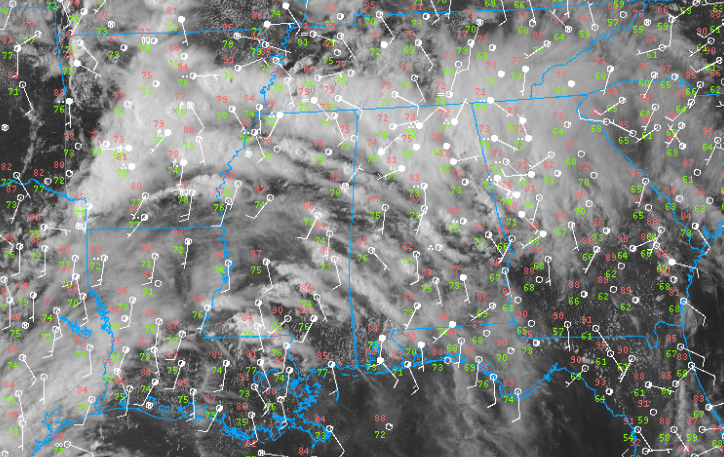
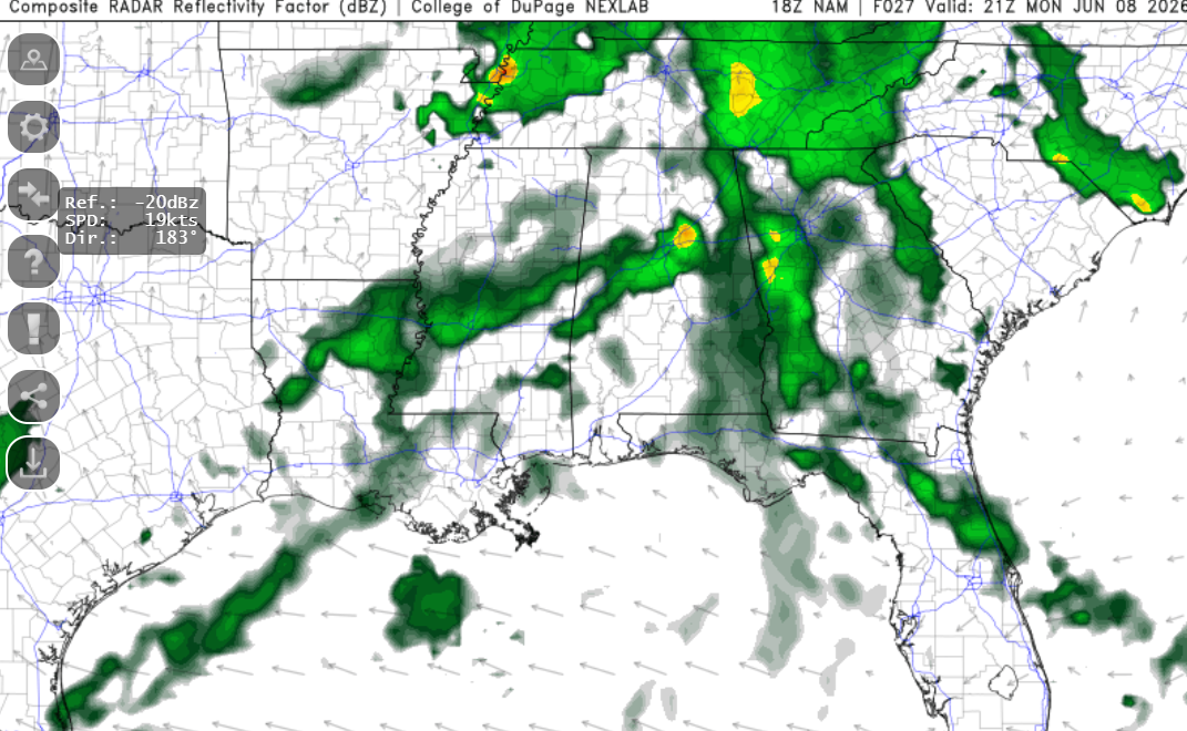
Satellite imagery shows widespread, weak showers and thunderstorms developing across the region. These storms are being fueled by deep gulf moisture and strong surface heating.
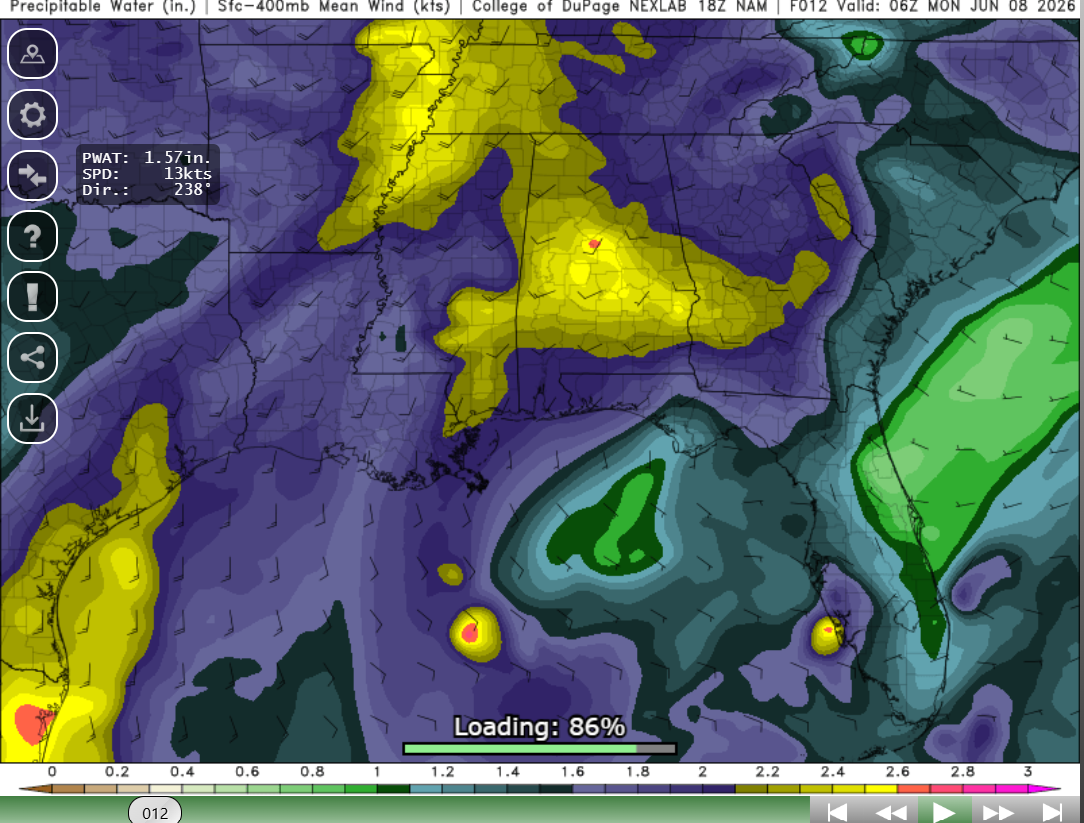
These high values mean a water loaded column which will lead to intense precipitation rates (and maybe some flash flooding). This can lead to strong downdrafts and maybe some wet microbursts (but not likely). As usual, expect frequent lightning. Not everyone will get soaked but the areas that do will feel it.
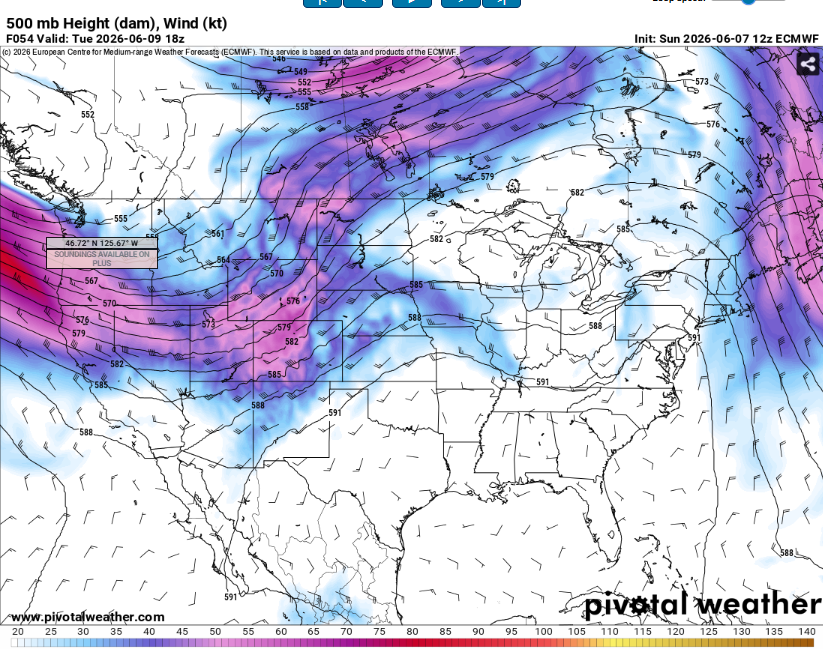
The position of the jet stream means that there is little in the way of vertical wind shear across the southeast. That means minimal severe weather and instead slow moving, weak storms. This is not uncommon for this time of year and looks to stick around for the foreseeable future.
Tomorrow will be another hot and humid day. Some storms will develop in the afternoon but not everywhere.
The jet stream may begin to slide south in about a week. This may lead to more widespread rain and therefore some cooler temperatures (still not cold or pleasant). It probably won’t get far enough south to cause major impacts, just enough to give us a tickle.
Airport Forecasts
Houston (KIAH/KHOU)- Mostly good, all things considered. Storms will die off around sunset. Tomorrow should be partly sunny and dry, so no issues.
Shreveport (KSHV)- Some storms in the area through mid evening. This may cause a lightning delay but it won’t be for long. Tomorrow looks great for flying with no weather issues expected.
Baton Rouge (KBTR)- Storms in the area now will die off after sunset. Some lightning is possible tomorrow afternoon but storms should be scattered enough that any delay would not be super long.
New Orleans (KMSY)- Isolated thunderstorms possible tonight and tomorrow afternoon. Nothing major but there may a quick delay or two for lightning or downbursts.
Jackson (KJAN)- Maybe a quick slowdown for lightning in the next couple hours for lightning but tonight and tomorrow morning will be all good. A slim chance for a lightning or microburst delay tomorrow afternoon if a thunderstorm is in the wrong spot.
Mobile (KMOB)- Storms are dissipating now. Tomorrow should be dry so no issues expected.
Birmingham (KBMH)- Off and on storms for the next couple days. It won’t be a washout but there may be some delays for lightning or wind. Tomorrow morning looks the driest.
Tallahassee (KTLH)- No issues are expected. Can’t rule out fog but it looks fine for the most part.
Atlanta (KATL)- On and off storms for the next couple days. Most flights will be fine but there may be some delays for lightning or downbursts.
Highways
I-10 – Mostly dry and fine. A couple thunderstorms are possible tomorrow afternoon in Louisiana but will only produce rain and lightning.
I-20 – Slowly clearing up this evening. Rain and storms are likely between Jackson and central Alabama tomorrow though, so watch for ponding on the roadways.
I-49 – Maaaaaaaybe an isolated shower tomorrow afternoon but nothing major. Areas north of Shreveport may get some storms this evening.
I-55 and I-59 – Isolated showers and storms across Mississippi tomorrow but nothing crazy. Just be cautious in the rain (Hydroplaning is not as cool as it sounds).
I-65 – Probably the most likely to see rain and storms on this list. Tonight and again tomorrow afternoon from central Alabama and north. Nothing severe, but heavy rain and lightning likely.
I-75 – Storms will be in the area tonight in northern Georgia. Same locations will also likely get tomorrow so be mindful of water on the pavement. Again, nothing severe, but maybe some heavy rain and lightning.
City Forecasts
Houston, TX
Tonight- Mostly cloudy with a low in the upper 70s. Storms dying off in the evening.
Tomorrow- Partly sunny with a high in the upper 80s. Humid but no rain.
Tuesday- Partly sunny with a high around 90. Dry, with less clouds than the day before.
Shreveport, LA
Tonight- Storms die off after sunset. Mostly cloudy with a low in the upper 70s.
Tomorrow- Mostly sunny with a high in the low 90s. Humid but no storms.
Tuesday- More of the same. A little hotter and sunnier than Monday. Highs in the mid 90s.
Baton Rouge, LA
Tonight- Storms fall apart after dark. Mostly cloudy with a low in the mid 70s.
Tomorrow- Increasing clouds with scattered afternoon storms. High in the upper 80s.
Tuesday- Rinse and repeat. High around 90 with clouds growing into scattered storms by mid afternoon.
New Orleans, LA
Tonight- Storms die off after sunset. Mostly cloudy with a low in the upper 70s.
Tomorrow- Increasing clouds with a high in the mid 80s. Isolated afternoon storms likely.
Tuesday- Partly sunny with a chance of afternoon thunderstorms. High in the upper 80s.
Jackson, MS
Tonight- Mostly cloudy with a low in the mid 70s. Thunderstorms dissipate around sunset.
Tomorrow- An isolated storm possible in the afternoon. Mostly cloudy with a high in the upper 80s.
Tuesday- Sunny and hot with a high in the low 90s. No rain is expected.
Birmingham, AL
Tonight- Cloudy with a low around 70. Scattered storms throughout the first half of the night.
Tomorrow- Scattered afternoon thunderstorms likely. High in the low 80s and mostly cloudy.
Tuesday- High in the upper 80s with scattered thunderstorm chances in the afternoon. Increasing clouds as storms build.
Mobile, AL
Tonight- Mostly cloudy with a low in the mid 70s. Storms will die off around sunset.
Tomorrow- Mostly cloudy with a high in the upper 80s. No rain is expected.
Tuesday- Partly sunny with a high around 90. Dry.
Tallahassee, FL
Tonight- Mostly cloudy with a low in the mid 70s. No rain expected.
Tomorrow- Partly sunny and humid. High in the low 90s but no rain.
Tuesday- Isolated thunderstorms possible in the afternoon. Partly sunny with a high around 90.
Atlanta, GA
Tonight- Scattered thunderstorms with a low around 70. Mostly cloudy.
Tomorrow- Afternoon thunderstorms likely with a mostly cloudy sky. High in the upper 70s.
Tuesday- Widespread showers and storms. Mostly cloudy with a high in the lower 80s.


