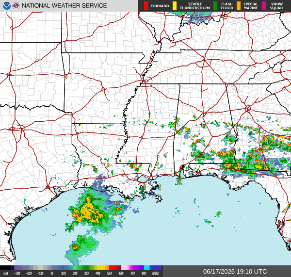
As I’m writing this at 2:45p CDT, there’s a few scattered storms across our region, with the area bounded by Tuscaloosa, Birmingham, and Montgomery seeing the most storm activity. If you look south of Louisiana, you’ll see tropical storm Arthur, which became the first named storm of the 2026 Atlantic hurricane season this morning.
While the center of tropical storm Arthur is currently over land near Bay City, TX, the heaviest rain bands of the storm are situated over the gulf and will move northeast into southeastern Louisiana later tonight. By the overnight and early morning hours, the heaviest rain bands will have moved into southern Mississippi. By tomorrow afternoon, the storm will have moved into Alabama.

A widespread 2-4″ of rain is expected from tropical storm Arthur between Lafayette and Montgomery from now until Friday morning, with some localized areas likely to see totals much higher than that. The area most likely to see more than that is the area bounded by Jackson, McComb, and Hattiesburg. Flash flooding is highly likely tonight and tomorrow. If you are driving and see a flooded road, turn around and don’t drown!
Airport Forecast
KHOU/KIAH (Houston) – Current: temperature is 88ºF, dew point is 74ºF, skies are mostly cloudy, winds are very gusty, coming out of the southeast at 16 mph, and visibility is 10 miles. Tonight, skies will clear up some and winds will calm, but no precipitation is forecasted. Some delays and cancellations are expected due to tropical storm Arthur, but the worst of it is behind us.
KATL (Atlanta) – Current: temperature is 85ºF, dew point is 70ºF, skies are mostly cloudy, winds are gusty coming out of the southwest at 13 mph, and visibility is 10 miles. Tonight, there is a slight chance of storms, but very minor delays are possible.
KMSY (New Orleans) – Current: temperature is 87ºF, dew point is 76ºF, skies are overcast, winds are gusty coming out of the south at 18 mph with gusts up to 26 mph, and visibility is 10 miles. Tonight, heavy showers and storms are expected, with gusty winds from tropical storm Arthur expected to continue. Significant delays and cancellations are expected.
KBTR (Baton Rouge) – Current: temperature is 87ºF, dew point is 75ºF, skies are mostly cloudy, winds are very gusty coming out of the south at 21 mph with gusts up to 29 mph, and visibility is 10 miles. Tonight, heavy showers and storms are expected, with gusty winds persisting due to tropical storm Arthur. Significant delays and cancellations are expected.
KSHV (Shreveport) – Current: temperature is 90ºF, dew point is 73ºF, skies are partly cloudy, winds are gusty coming out of the south at 14 mph with gusts up to 26 mph, and visibility is 10 miles. Tonight, there is a chance of storms, and winds will calm down a bit. Some delays are possible.
KJAN (Jackson) – Current: temperature is 89ºF, dew point is 78ºF, skies are mostly cloudy, winds are coming out of the south at 10 mph with gusts up to 23 mph, and visibility is 10 miles. Tonight, winds will continue to pick up a bit due to tropical storm Arthur, and there is a chance of heavy storms and showers. Some delays and cancellations are expected.
KBHM (Birmingham) – Current: temperature is 87ºF, dew point is 72ºF, skies are mostly cloudy, winds are coming out of the south at 10 mph, and visibility is 10 miles. Tonight, some showers and storms are expected. Very minor delays are possible.
KMOB (Mobile) – Current: temperature is 84ºF, dew point is 78ºF, there is a light rain, winds are coming out of the southwest at 14 mph with gusts up to 23 mph, and visibility is 7 miles. Tonight, there’s a chance of storms and showers, and winds will continue to be gusty. Some minor delays are possible.
KTLH (Tallahassee) – Current: temperature is 85ºF, dew point is 76ºF, skies are mostly cloudy, winds are coming out of the south at 7 mph, and visibility is 10 miles. Tonight, there’s a slight chance of storms and showers. No delays or cancellations are expected.
Highway Forecast
I-10: Tonight, the heavy rain bands of tropical storm Arthur are expected to pass through the area between Houston and New Orleans, particularly east of Lafayette. Very heavy rain is expected tonight, creating poor driving conditions and possible road flooding. Heavy rain and gusty winds are still expected east of New Orleans, but driving conditions will be a bit better than west of New Orleans.
I-20: Most of the heavy rain from tropical storm Arthur will be too far south for this highway, however some scattered storms and showers may pop up, especially closer to Birmingham. Overall, driving conditions are average.
I-49: The parts of this highway most likely to experience heavy rain from tropical storm Arthur is the area between Lafayette and Alexandria. North of Alexandria, there is still a chance for heavy rain and storms, but it is not as severe. Rains could get very heavy tonight near Lafayette, creating very poor driving conditions.
I-55: The area from Laplace to just south of Jackson will experience the heaviest rain tonight. Poor driving conditions are expected tonight in that area, with flooded roads possible. Jackson and further north, the worst of tropical storm Arthur is expected to be tomorrow morning, but tonight driving conditions will be average.
I-59: The heaviest rain from tropical storm Arthur is expected between Hattiesburg and Slidell tonight. Here, driving conditions are expected to be very poor. Past Hattiesburg, there is still a chance of heavy rain, but driving conditions are expected to be average.
I-65: Tonight, the area between Birmingham and Mobile will likely see some pop up storms, which could bring lightning, heavy rains, and gusty winds. These storms should be gone by 6 tonight. Overall, driving conditions are decent.
I-75: Potentially strong storms are likely to develop in the area between Atlanta and Tallahassee, particularly near Valdosta. These storms could bring heavy rain, gusty winds, and lightning, and should be gone by 6 tonight. Everywhere else, driving conditions should be decent tonight.
3 Day City Forecast
Tallahassee, FL
Tomorrow: Skies will be cloudy tomorrow with a high of 86ºF. Some heavy showers and storms will move into the area tomorrow morning and will persist all day. Rainfall totals could be between a quarter inch and an inch of rain. Temperatures should fall into the mid-upper 70s tomorrow night.
Friday: Skies will be stormy for most of the day Friday with a high of 89ºF. There is a chance of storms and showers in the early morning, then another chance later in the afternoon and evening. Most storms should be wrapped up by 6 pm. Winds may be pretty gusty on Friday, with gusts up to 25 mph. Temperatures should fall into the mid 70s by Friday night.
Saturday: Skies will be stormy for most of the day on Saturday with a high of 90ºF. There is a chance of storms in the early morning, then another chance of storms in the afternoon and evening. Temperatures should fall into the mid 70s by Saturday night.
Birmingham, AL
Tomorrow: Heavy rain from tropical storm Arthur will soak Birmingham tomorrow beginning in the early morning and lasting into the late evening. Rain totals could approach 2″. High of 79ºF. Winds will be gusty throughout the day tomorrow, with gusts up to 20 mph. Temperatures should drop into the low 70s tomorrow night.
Friday: There is a chance for storms and showers in the morning, but skies will clear up as the day goes on. High of 85ºF. Temperatures should drop into the upper 60s-low 70s Friday night.
Saturday: There is a chance of storms in the early morning and morning hours, but skies should clear up a bit as the day goes on. The high will get up to 87ºF. Temperatures should fall into the low 70s on Saturday night.
Mobile, AL
Tomorrow: Heavy rain from tropical storm Arthur will soak Mobile tomorrow morning until tomorrow night. Rainfall totals will be around 2-4″. Winds will be gusty at a persistent 15 mph and gusting up to 30 mph. High will get up to 83ºF. Temperatures should fall into the mid-upper 70s tomorrow night.
Friday: Skies will be cloudy in the morning, but will clear up significantly throughout the day. High will get up to 90ºF. There is also a slight chance of storms in the evening. Temperatures should fall into the mid 70s on Friday night.
Saturday: Skies will be partly sunny throughout the day following a chance of storms in the morning. Then, there’s another chance of storms in the afternoon and evening. The high should get up to 90ºF. Temperatures should fall into the mid 70s on Saturday night.
Atlanta, GA
Tomorrow: Some heavy rain showers and storms from tropical storm Arthur will move into the area tomorrow afternoon. Rainfall totals will be between half an inch and an inch of rain. High will get up to 82ºF. Winds will be somewhat gusty throughout the day tomorrow. Temperatures should fall into the low 70s by tomorrow night.
Friday: The chance of storms and showers will exist for all of Friday, particularly in the morning, and in the late night hours of Friday. The high will get up to 83ºF. Winds will be a bit gusty on Friday, with gusts up to 15 mph. Temperatures should fall into the upper 60s-lower 70s on Friday night.
Saturday: Skies will be mostly sunny for the day on Saturday following a chance of storms in the morning. The high will get up to 87ºF. Temperatures should fall into the low 70s on Saturday night.
Jackson, MS
Tomorrow: Very heavy rain from tropical storm Arthur will move into the area late tonight and into the early hours of tomorrow. Rainfall totals could be excessive, with around 2-4″ expected. The heaviest rain is expected tomorrow morning. Most of the rain from Arthur should be gone by tomorrow afternoon. Winds will be gusty tomorrow, gusting up to 20 mph. The high will reach 85ºF, and temperatures should drop into the mid 70s by tomorrow night.
Friday: Skies should be partly cloudy throughout the day on Friday with a high of 88ºF. In the evening and night, there’s a chance of potentially strong storms. Rainfall totals of around half an inch are possible. Temperatures should drop into the lower 70s on Friday night.
Saturday: There is a chance of showers and storms in the early morning hours of Saturday as well as in the evening. The high will reach 89ºF. Temperatures should drop into the mid 70s by Saturday night.
New Orleans, LA
Tomorrow: Heavy rains from tropical storm Arthur will move into the area tonight and will last until tomorrow morning. After that, there is still a chance of storms throughout the day. The high will reach 90ºF. Rainfall totals from tonight into tomorrow morning could be around 2-3″. Winds will be gusty, gusting up to 25 mph in the early morning. Temperatures should fall into the lower 80s tomorrow night.
Friday: Skies should be mostly sunny throughout the day on Friday with a high of 92ºF. In the evening and night there is a chance of scattered showers and storms. Temperatures should fall into the low 80s on Friday night.
Saturday: There is a slight chance of showers in the morning, after that skies will be partly sunny with a high of 91ºF. There is also a chance of scattered showers and storms in the afternoon and evening of Saturday. Temperatures should fall into the low 80s on Saturday night.
Baton Rouge, LA
Tomorrow: Heavy showers and storms are likely in the morning, then more showers are likely throughout the afternoon. Skies will clear up a bit in the evening. The high will get up to 88ºF. Temperatures should fall into the upper 70s and low 80s tomorrow night.
Friday: There is a slight chance of showers and storms in the morning, after that skies will clear up and the high will reach a hot 93ºF. There’s a chance of some showers and storms in the late evening and night. Temperatures should drop into the upper 70s on Friday night.
Saturday: There is a slight chance of showers in the mid morning, after that skies will clear up and the high will reach 91ºF. There is a chance of pop up storms in the afternoon and evening on Saturday. Temperatures should fall into the mid-upper 70s on Saturday night.
Shreveport, LA
Tomorrow: There is a chance of some lingering showers and storms in the morning and early afternoon, after that skies will clear up and the high will reach 93ºF. There’s also a slight chance of storms and showers tomorrow night. Temperatures should drop into the upper 70s tomorrow night.
Friday: Skies will be partly sunny throughout the day tomorrow with a high of 89ºF. Then, there’s a chance of storms and showers in the evening around 3-6p, then again around 9. Temperatures should fall into the mid 70s on Friday night.
Saturday: Skies will be mostly cloudy throughout the day on Saturday with a high of 89ºF. There’s a chance of scattered storms and showers in the morning, then again in the evening and late afternoon. Temperatures should fall into the mid-upper 70s on Saturday night.
Houston, TX
Tomorrow: Skies will be mostly sunny tomorrow with a hot high of 94ºF. The heat index could get up to a sweltering 116ºF. The chance of any precipitation is very low. Temperatures will only drop into the low 80s tomorrow night.
Friday: Skies will be sunny throughout the day on Friday with another hot high of 94ºF. The heat index will get to 110ºF. There is a slight chance of scattered showers and storms late Friday night. Temperatures will drop into the low 80s on Friday night.
Saturday: Skies will be partly sunny throughout the day on Saturday with a high of 93ºF. There is a slight chance of scattered showers and storms in the afternoon and evening on Saturday. Temperatures will drop into the low 80s on Saturday night.


