Today, there was catastrophic flash flooding, damaging winds, and tornadoes… thanks, Arthur. The leftovers of post-tropical cyclone Arthur are accelerating east tonight into northwest Alabama, leaving us with plenty of warm, moist air available for scattered storms and driving up heat indices going into the weekend.
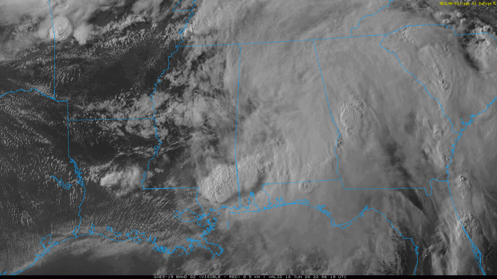
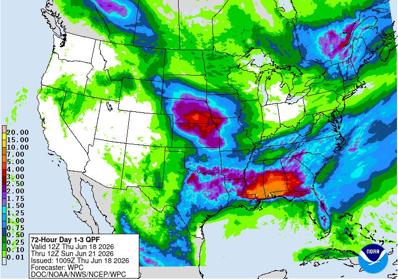
Arthur’s remnants wreaked havoc across the Southeast today, with estimated rainfall totals of 21″ in Plaucheville, LA, and 11″ in Wiggins, MS, leading to dangerous, life-threatening flash flooding. Some homes have taken on waist-deep water, and widespread road closures continue across South Mississippi. Officials say many roads are impassable. This is not the day to be driving through flooded roadways!
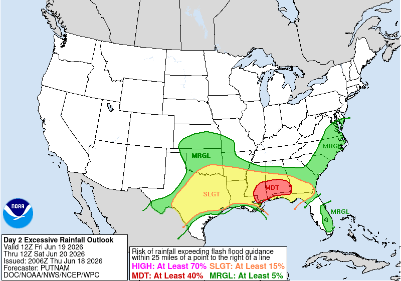
Heavy rainfall and widespread flash flooding are likely across parts of the Southeast through the next day or two, highlighted by a Moderate Risk of excessive rainfall tomorrow.

TONIGHT
Short-range models show rain continuing into the evening and overnight hours before we begin to see slightly drier conditions. Those in Louisiana have a lower-end chance of storms compared to coastal Mississippi and the Meridian area.
TOMORROW
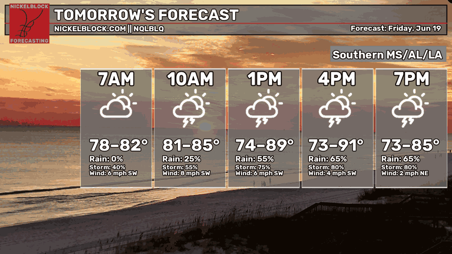
Friday, it will feel quite steamy as a combination of temperatures in the 90s and the plume of moisture Arthur left behind pushes heat indices to near 110 degrees.
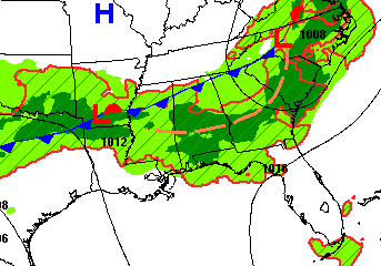
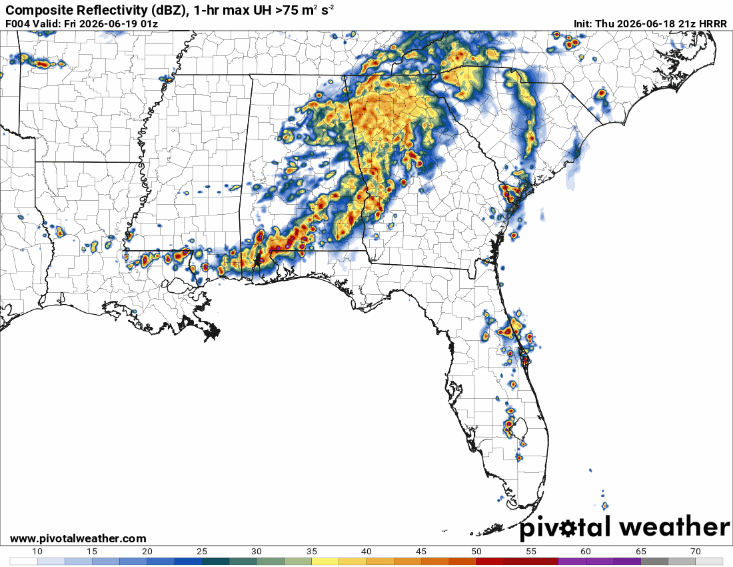
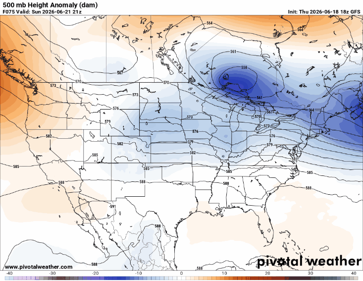
A low-pressure system approaching from the west and its associated cold front may linger across the region, along with a trough (indicated by the dashed yellow line). Combined with leftover moisture and this added lift, numerous showers and thunderstorms are expected to develop during the afternoon and evening hours. Some storms may become severe, producing damaging wind gusts, intense downpours, and perhaps a brief tornado.
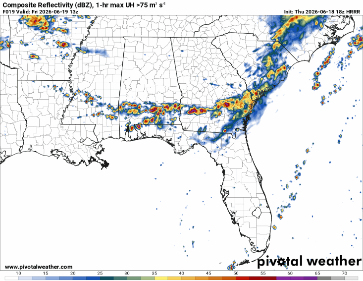
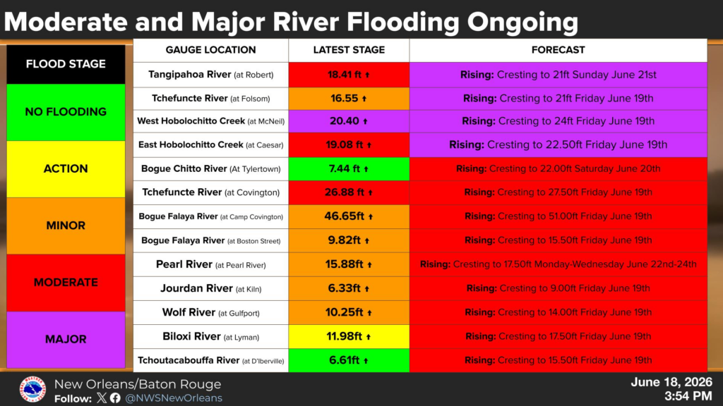
Flash flooding remains a concern tomorrow due to locally heavy rainfall on areas that received extreme rainfall totals today. Many rivers have already risen past flood stage and are expected to reach moderate to major flood levels (shown in the chart below).

THE DAY AFTER TOMORROW
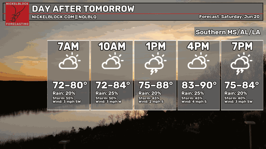
Showers/storms will continue through Saturday as the front previously mentioned lingers across the area. The boundary will gradually weaken and may lift north Saturday night. Total rainfall from today and through the weekend will be impressive, with widespread amounts exceeding 5 inches.

EXTENDED OUTLOOK
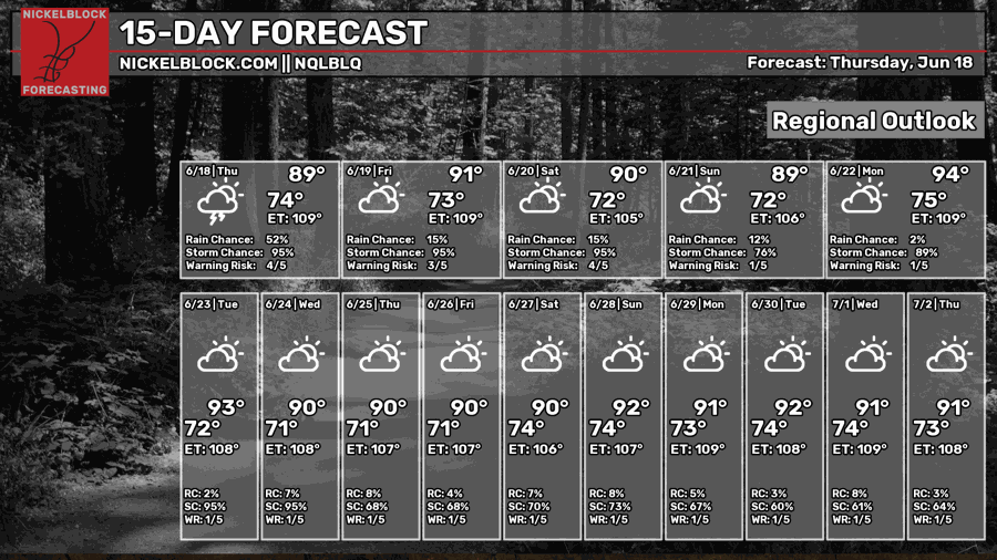
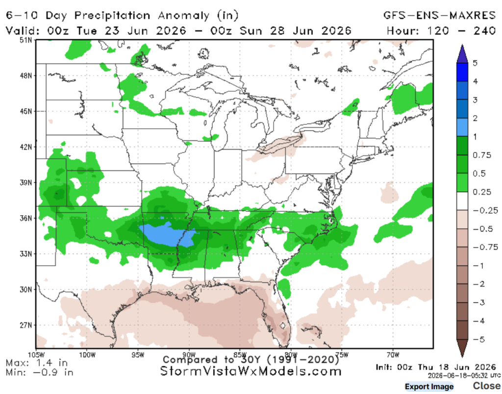
Ridging builds in by Sunday and remains in place through next week, allowing for a return to more typical rain chances and temperatures. Highs will climb into the 90s, with overnight lows in the 70s.
Once we get through this week, the model guidance that looks out into next week points back to normal conditions for us, with isolated afternoon showers/storms expected. A little soggy for our friends north of Jackson as ridging is a bit weaker there.
DAY-BY-DAY FORECAST
Today – Flood watch in effect. Highs in the 80s. Heavy showers/thunderstorms are forecasted to train over coastal Mississippi, where significant flash flooding is likely. Damaging wind gusts and brief, weak tornadoes are possible. Jackson and coastal Louisiana will be drier, with isolated storms possible. Southwest wind blowing at 10 mph, with gusts as high as 30mph.
Tonight – Flood watch in effect. Rain coverage decreasing overnight but cannot rule out an isolated storm. Otherwise, mostly cloudy. Low near 76. Southwesterly wind at 10-15 mph.
Friday – Heat and humidity continue building with highs near 90, may feel closer to 110. An unsettled pattern with numerous showers and thunderstorms storms expected all day, some severe and some with intense downpours, mainly during the afternoon hours. Flash flooding likely. Rain chance: 70%. Light south wind.
Friday Night – A few showers and thunderstorms will linger overnight under mostly cloudy skies. Low near 74. South wind around 5 mph. Rain chance: 70%.
Saturday – Wet weather hangs around into the weekend with additional showers and thunderstorms likely, mainly in the afternoon. Highs hovering around 90, humidity will make it feel 10 degrees warmer. Rain chance: 70%
Saturday Night – A few showers and storms may linger overnight under mostly cloudy skies. Low around 75. South wind around 5 mph. Rain chance: 50%
Sunday– Wet weather hangs around into the weekend with additional showers and thunderstorms likely. Highs stay hovering around 90. Otherwise, partly sunny. South wind 5 to 15 mph. Rain chance: 50%
Sunday Night – Partly cloudy but cannot rule out an isolated storm. Low near 73. South wind around 10 mph, with gusts as high as 15 mph.
Monday – Mostly sunny, finally drier weather. Highs near 90. Southwest wind 5 to 10 mph, with gusts as high as 20 mph.
Monday Night – Mostly clear, with a low around 75. Southwest wind 5 to 10 mph. Chance for rain or storms around 10% to 20%
Tuesday – Partly sunny, with chance of isolated storms in the afternoon. Rain chance: 40%. Highs push close to 90. Calm westerly wind.
Tuesday Night – Partly cloudy and mild overnight with lows near 70. A slight chance of showers and thunderstorms. Southwest wind around 5 mph.
Wednesday – Partly cloudy. A few afternoon thunderstorms may pop up after 1pm, some severe, but much of the day stays dry. Rain chance: 50%. Highs pushing 90 for some folks, low 80s for others.
Wednesday Night – A stray evening shower remains possible before skies settle into a partly cloudy night. Low around 73. Rain chance: 20%


Thank you, Ella. Great job on the report!