Howdy and thank you for taking the time to read my first research project!! Discussing and researching climate change is something I love doing, so I wanted to do something related to that and also related to tropical weather for this project. Hurricane Melissa had devastating impacts to Jamaica last year, and it had intensified greatly in such a short period of time. I want to see if that can be attributed to climate change.
Hurricane Melissa is particularly interesting as it is one of the strongest recorded hurricanes in the Atlantic Basin, and in just 48 hours, the storm intensified from a tropical storm to a category 5. The storm at its maximum intensity had winds speeds up to 165 kts (190 mph) and had a minimum central pressure of 892 mb (Kelly et. al. 2025). It was a slow-moving storm, leaving catastrophic impacts to Jamaica due to high winds, storm surge, heavy rainfall and flooding. Almost 100 known causalities were recorded across the Caribbean.
Melissa occurred on October 21, 2025, through October 31, 2025. In doing this research, it is important to look at the lifecycle of the hurricane, the impacts, and if climate change played a part in it all.
THE LIFE CYCLE OF HURRICANE MELISSA
On October 13, a tropical wave from the west coast of Africa moved west with active convection associated with it. It propagated quickly west for a few days. By October 20, it had slowed as it moved over the central Caribbean and was organizing a lot better. Tropical storm force winds were already achieved, and by 0600 UTC October 21, a well-defined low level circulation center had developed. At this point, the system is a tropical storm.
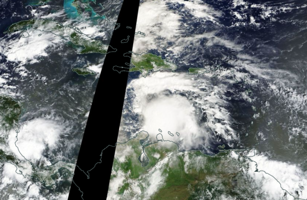
Its slow movement can be attributed to its positioning relative to a mid-level ridge to its north and a trough that was over the western Caribbean. This weaker steering flow and some moderate wind shear in the Caribbean Sea had initially limited the cyclone to intensity from October 22-24. By the 25th, wind shear relaxed as the storm propagated over very warm water, so it was able to intensity to hurricane strength. Still being around 175 miles from Jamaica, it continued to intensify, warm waters and high heat content fueling it. The eyewall became better organized and visible.
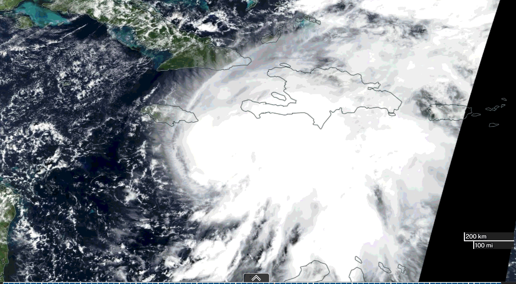
Hurricane Melissa became a major hurricane (category 3 or higher) by 0600 UTC on October 26 and intensified to a category 4 by 1800 UTC on the same day. Winds were reaching near 140 mph at this point, and it was located south of Jamaica. The storm continued to strengthen as it propagated slowly northwestward, reaching category 5 by 1200 UTC on October 27, just 120 nautical miles south of Jamaica. The mid-level ridge had weakened at this point and the trough moved closer to the Caribbean Sea. This resulted in Melissa being steered north-northeast sharply heading to western Jamaica. Peak intensity was reached around 1200 UTC on October 28 with 165 kt winds and a minimum pressure of 892 mb. See below for satellite imagery of the storm passing over Jamaica (from NASA Worldview)
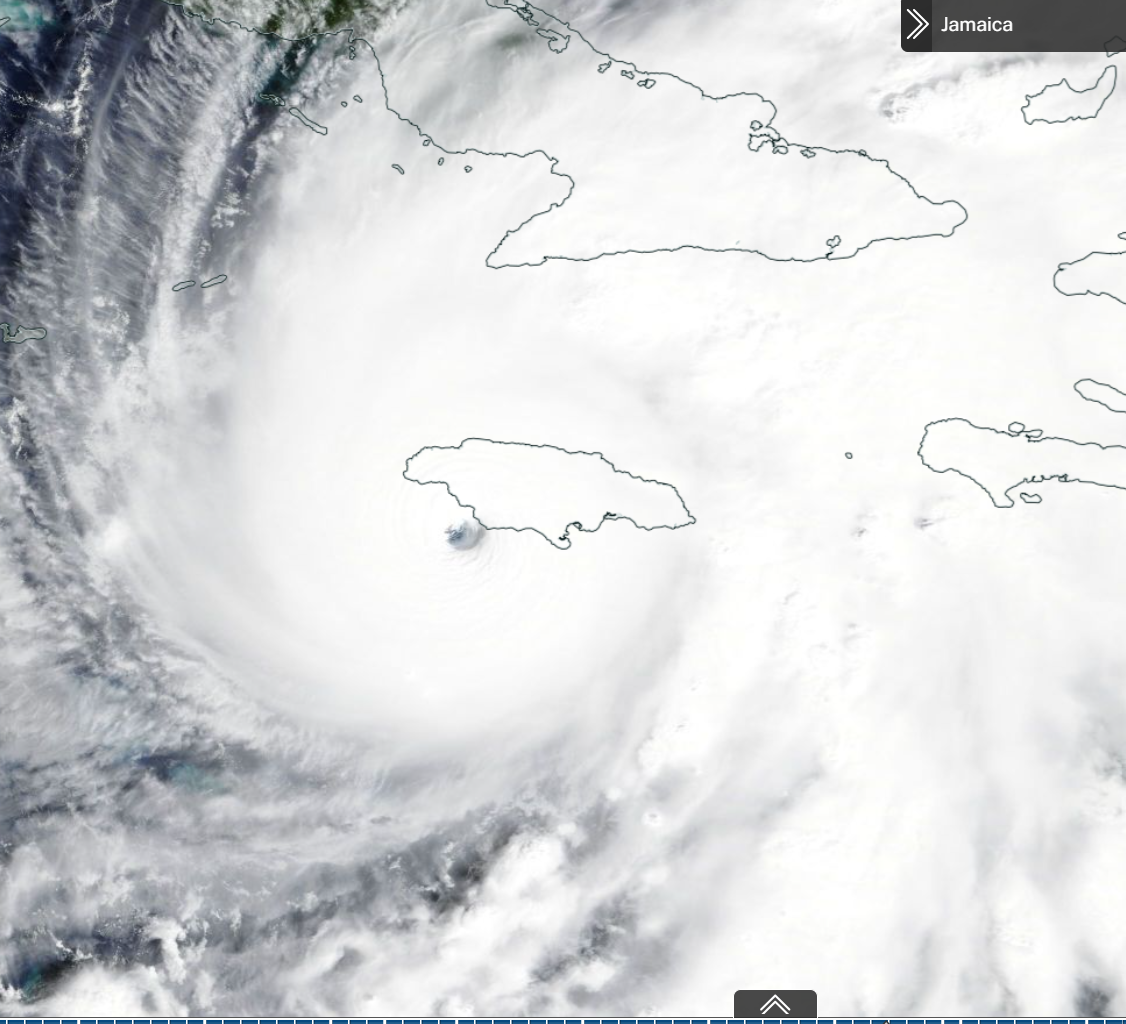
On the same day around 1725 UTC, Hurricane Melissa made landfall in New Hope, Jamaica as a category 5 with sustained winds at 160 kts. As it moved north northeastward over Jamaica, it left devastating impacts. It then went on to Cuba on October 29 as a category 3 (the Jamaican terrain had weakened the storm), sustained winds at 100 kts. After Cuba, it propagated over The Bahamas as a category 1 hurricane on the same day.
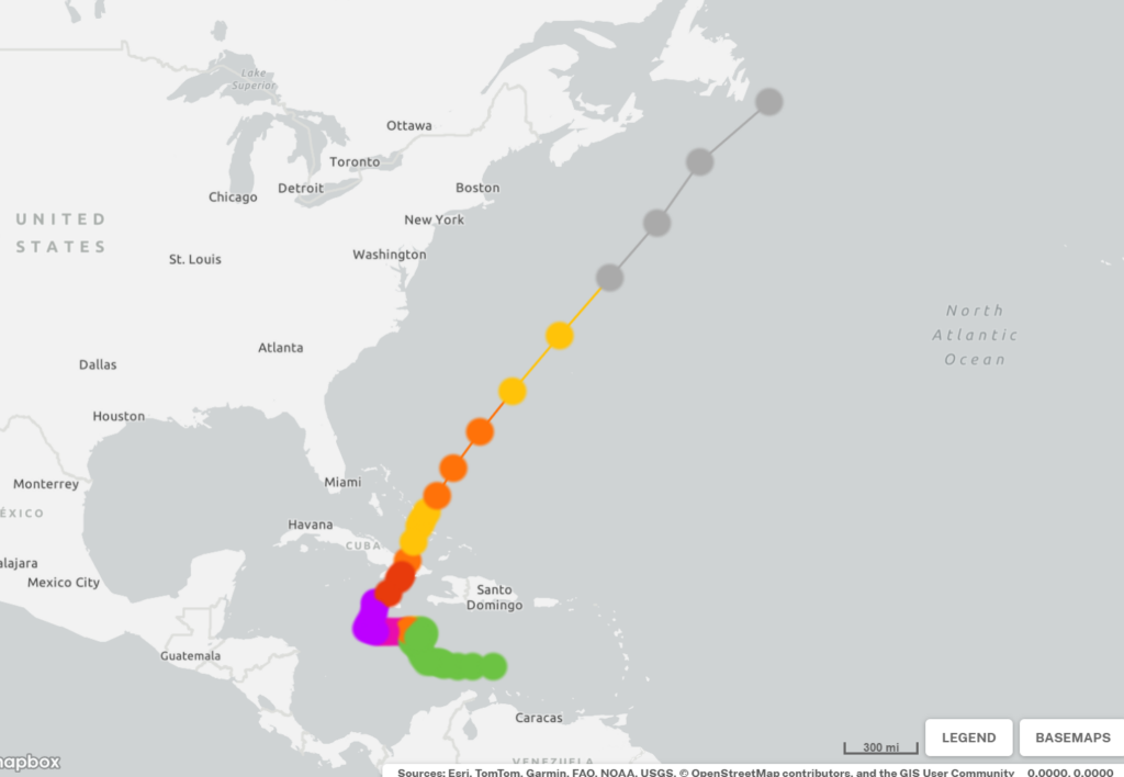
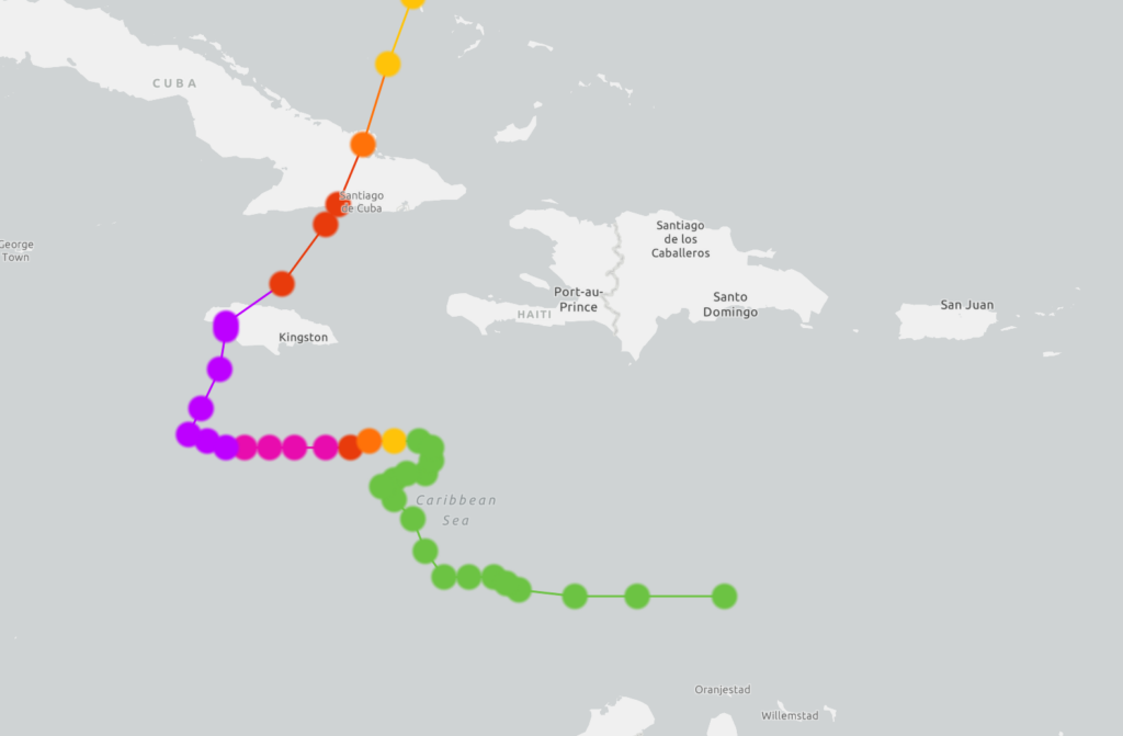
After its journey through the Caribbean, it had briefly strengthened on October 30 before heading northeastward toward Bermuda. By October 31, it had lost all its tropical characteristics and became a post-tropical cyclone. It completely dissipated by November 1 (see below from NOAA for track, right one showing closer to Jamaica. Purple indicates category 5).
IMPACTS
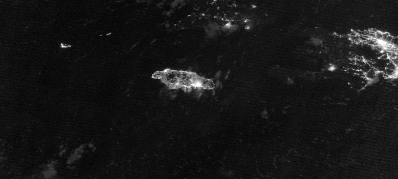
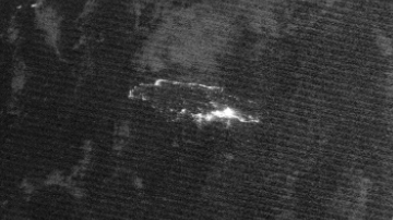
Impacts from the storm were seen in Jamaica, Cuba, Haiti, the Dominican Republic, the Bahamas, Puerto Rico, in the Virgin Islands, coastal Colombia, and parts of Lesser Antilles. Jamaica had the worst impacts as it was hit directly by a category 5 hurricane. Below are two images (from NASA Worldview) from before Melissa (on the left) and a couple days after Melissa (on the right). These images show how much power and electricity was lost especially for western Jamaica. An estimated $12.2 billion US dollars were lost, making this event one of the most severe economic disasters in the islands history.
Houses and buildings were destroyed. Along coastal towns like New Hope and Black River, nearly all the houses were deemed inhabitable. Hospitals were damaged, which impacted the ability for people to get proper medical care. Roads and transportation networks were inaccessible, leaving some communities isolated. Storm surge up to 11ft impacted the coastal regions, devastating flooding occurred. Power outages occurred across the island. After the storm, Jamaica was left under a humanitarian crisis for some time.
Jamaica was not the only country impacted, Cuba, Haiti, and the Bahamas faced major flooding and destruction to infrastructure. Lives were also lost. In total between all the countries and regions, there were 93 known casualties (Kelly et. al. 2025). In result, Hurricane Melissa became one of the strongest recorded hurricanes in the Atlantic Basin and was the strongest hurricane in 2025 globally.
SO WHY WAS THE STORM SO INTENSE?
Many studies have been conducted to why Melissa had rapidly intensified in such a short time. Natural variability is a factor in this, but is there more to it?
According to a study done by Climate Central, the ocean was unseasonably warm for the time of year, 1.4°C warmer on average for the area. These warm waters were 500 – 700 times more likely because of human-induced climate change. Oceans are warmer due to the fact that as greenhouse gas emissions continue, the ocean is able to absorb some of those emissions (mainly carbon dioxide) and this in turn warms the oceans and makes them more acidic over time. Also, the atmosphere is able to hold more water vapor (roughly ~ 7% more water vapor with every °C of warming), which also warms oceans and fuels hurricanes.
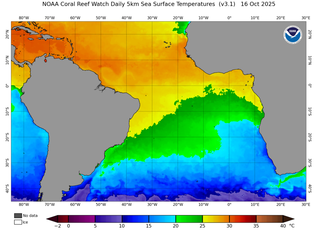
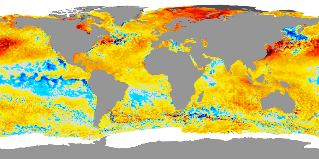
The graphs above from NOAA show the SST (on left) and the SST anomaly on October 16, 2025. We can see from the anomaly graph that the temperatures were indeed warmer than the average, especially for the Caribbean Sea. Hurricane Melissa was able to form and as it moved sluggishly through the warm ocean waters, it was able to escalate rapidly.
Another thing to factor in is that warmer SSTs = stronger wind speeds. At its maximum intensity (lowest pressure), winds reached 190 mph (165 kts), which is a rare occurrence (O’Malley 2025). According to a study done by the Imperial College of London, climate change had increased Melissa’s peak sustained winds by 7% (11mph), meaning winds were faster and almost two times more damaging due to climate change’s influence.
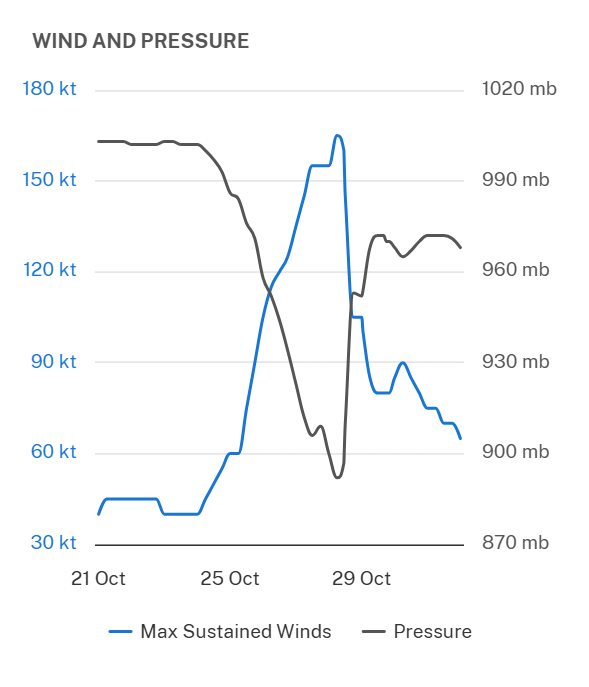
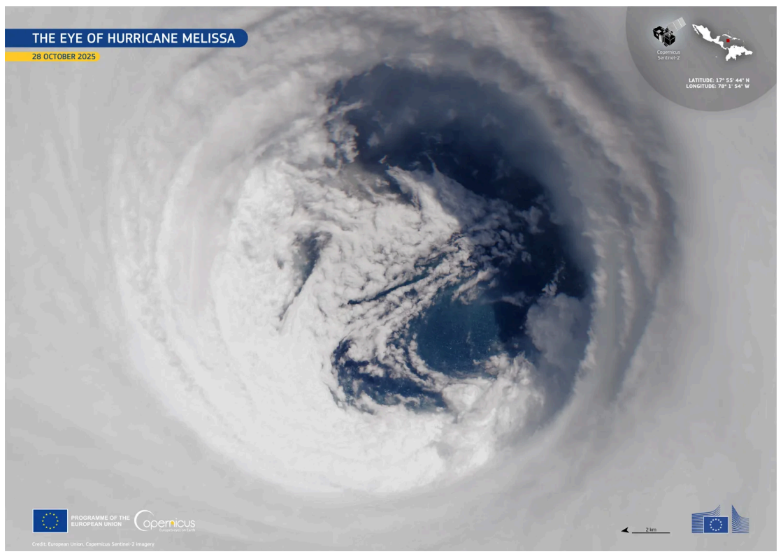
Above to the left (from NOAA), it can be seen how winds and pressure are inversely related, stronger winds occur with the lower pressures. To the right is an image from the European Union, Copernicus Sentinel-2 Imagery, of the eye that I thought would make a good visual to see with the graph.
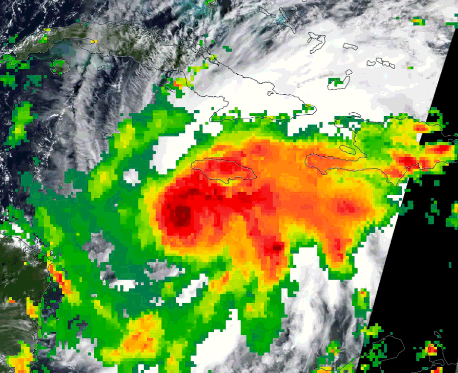
Another study by Faranda et al. (2025) found that Hurricane Melissa and storms like it are up to 10% wetter in the current climate. This relates back to how the atmosphere is able to hold more water vapor. Similarly, a study done by the World Weather Attribution Group estimates that for Melissa, rainfall was made 9% more intense, and specifically in Jamaica, the intensity of rainfall was 30% more intense and twice as likely in our present climate. Below shows the precipitation rates as the storm passed over Jamaica, darker colors (like the dark red, almost black) represent higher rainfall rates greater than 2 inches per hour. Some areas recorded up to 24-32 inches of rain in total, and according to NOAA/NWS, the heaviest rainfall being along and to the east of the center of the storm.
CONCLUDING THOUGHTS
It is no secret that human-induced climate change makes storms like Hurricane Melissa more intense. It is still an ongoing area of research on the direct impact climate change will have on hurricanes in the future, and storms like Melissa will help us gain a better understanding of it. The intensity and rapid intensification of Melissa have attributes to climate change, leaving it to be one of the strongest storms in the Atlantic Basin. Impacts are still seen today as countries continue to rebuild and recover.
Again, thank you so much for your time and I hope you learned something from this! I thoroughly enjoyed doing this project and learning all about the insane storm that was Hurricane Melissa.
REFERENCES
Faranda, D., G. Messori, and M. C. Alvarez-Castro, 2025: Strong winds and heavy precipitation in Hurricane Melissa enhanced by both human-driven climate change and natural variability. ClimaMeter, Institut Pierre Simon Laplace, CNRS. Accessed 19 June 2026, https://www.climameter.org/20251027-hurricane-melissa
National Aeronautics and Space Administration, 2025: IMERG precipitation rate, 30-minute. NASA Worldview. Accessed 19 June 2026, https://worldview.earthdata.nasa.gov/.
National Aeronautics and Space Administration, 2025: NASA Worldview. Accessed 19 June 2026, https://worldview.earthdata.nasa.gov/.
Rafferty, J. P., 2026: Hurricane Melissa. Encyclopaedia Britannica. Accessed 19 June 2026, https://www.britannica.com/event/Hurricane-Melissa
Kelly, L. A., J. Álamo, and A. D. Mahoney, 2026: Hurricane Melissa (AL132025), 21–31 October 2025. Tropical Cyclone Rep., National Hurricane Center, 85 pp., https://www.nhc.noaa.gov/data/tcr/AL132025_Melissa.pdf
NOAA Coral Reef Watch, 2026: Daily Global 5 km Satellite Coral Bleaching Heat Stress Monitoring Products (Version 3.1). National Oceanic and Atmospheric Administration. Accessed 19 June 2026, https://coralreefwatch.noaa.gov/product/5km/
Masters, J., 2025: Climate change strengthened Hurricane Melissa, making the storm’s winds stronger and the damage worse. Yale Climate Connections, 30 Oct. 2025, https://yaleclimateconnections.org/2025/10/climate-change-strengthened-hurricane-melissa-making-the-storms-winds-stronger-and-the-damage-worse/
U.S. News & World Report, 2025: Climate change boosted Hurricane Melissa’s destructive winds and rain, analysis finds. U.S. News & World Report, 6 Nov. 2025, https://www.usnews.com/news/us/articles/2025-11-06/climate-change-boosted-hurricane-melissas-destructive-winds-and-rain-analysis-finds
Faranda, D., G. Messori, and M. C. Alvarez-Castro, 2025: Strong winds and heavy precipitation in Hurricane Melissa enhanced by both human-driven climate change and natural variability. ClimaMeter, Institute Pierre-Simon Laplace (CNRS), accessed 19 June 2026, https://www.climameter.org/20251027-hurricane-melissa


