Say bye-bye to our friend, the low-pressure system, and hello to drier conditions and heat.
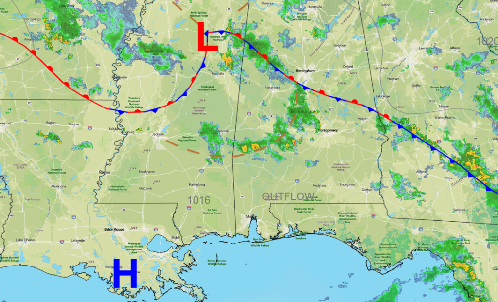
Wet weather will hang around one more day as the low departs. Especially across the northern portions of the region, where a marginal risk for excessive rainfall is in place on Wednesday. Meanwhile, relentless flash flooding is ongoing across central Texas.
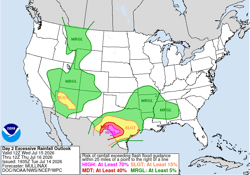
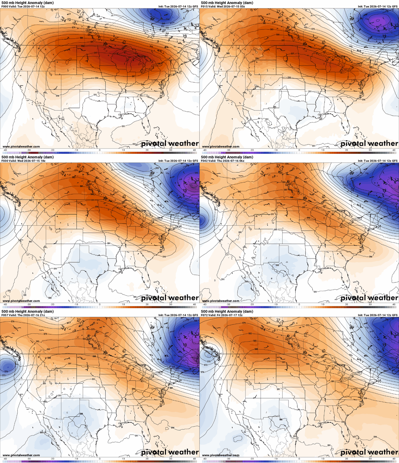
As the upper ridge expands westward (shown below), the low will depart, resulting in much lower rain coverage across the region. As we move forward through the week, expect temperatures to climb back into the mid to upper 90s.
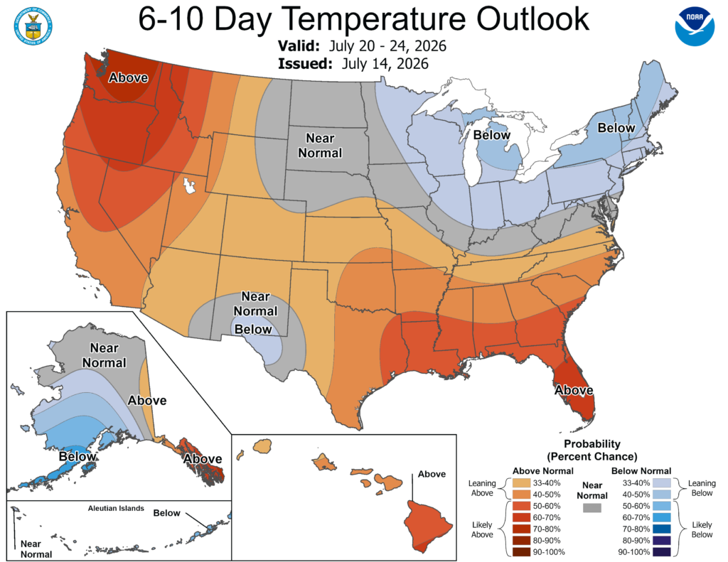
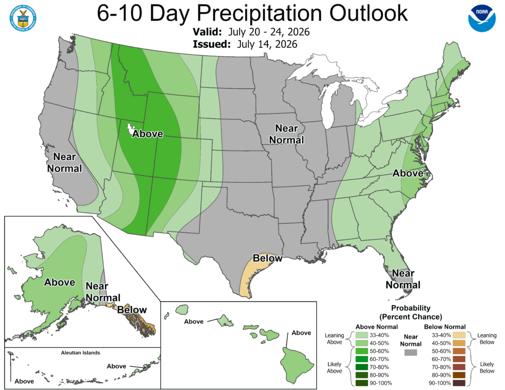
Looking ahead to next week, we’ll see a pattern change as our friends farther east could see above-normal precipitation. This is due to an area of low pressure being forecasted to deepen over the northeastern US next week. Meanwhile, temperatures will be running above normal across the region… the heat is here to stay!
3-DAY TRAVEL FORECAST
AIRPORTS
KIAH / KHOU (Houston) – Multiple rounds of showers and storms possible each day. Some intermittent flight delays are possible for lightning.
KSHV (Shreveport) – Scattered showers and thunderstorms are expected Wednesday. Some intermittent flight delays are possible for lightning. Drier weather returns Thursday.
KBTR (Baton Rouge) – Low-end chance for afternoon showers and storms possible Wednesday. Aside from that, no weather-related issues are anticipated through Thursday.
KMSY (New Orleans) – Afternoon showers and storms possible Wednesday. Some intermittent flight delays are possible for lightning, mainly between 3-5pm.
KJAN (Jackson) – Low-end chance for afternoon showers and storms possible Wednesday. Aside from that, no weather-related issues anticipated through Thursday.
KMOB (Mobile) – Low-end chance for afternoon showers and storms possible each day. Aside from that, no weather-related issues anticipated through Thursday.
KBMH (Birmingham) – Scattered showers and thunderstorms are expected through Wednesday. More typical summertime pattern on Thursday with spotty afternoon storms Some intermittent flight delays are possible for lightning.
KTLH (Tallahassee) – Low-end chance for afternoon showers and storms possible each day, mainly between 2-7pm. Some intermittent flight delays are possible for lightning.
KATL (Atlanta) – Low-end chance for afternoon showers and storms possible each day. A few storms tonight could produce heavy rainfall and minor flooding. Some intermittent flight delays are possible for lightning. But most flights between 10a and 2p should be not be impacted by weather.
HIGHWAYS
I-10
Looks pretty rainy between Houston and New Orleans through Wednesday. Be prepared for brief rounds of heavy rain, lightning and gusty wind. Watch for water on roadways!
Other than that, mostly dry, but can’t rule out a stray afternoon storm.
I-20
Hit or miss storms from Shreveport to Atlanta possible Wednesday. Better shot for rain near Shreveport. Be prepared for brief rounds of heavy rain, lightning and gusty wind.
Thursday looks drier, with much of the rain staying near and north of Atlanta.
I-49
Wednesday afternoon and evening, numerous showers and thunderstorms are likely between Alexandria and Shreveport. Thursday looks drier, with some spotty storms possible near Lafayette.
I-55 & I-59
Lookout for showers and storms between Jackson and West Memphis. Things should be drier south of Jackson through New Orleans.
I-65
Scattered showers and thunderstorms are expected through Thursday, with a better shot for rain near Birmingham. Weather seems to stay on the drier-side as you head south toward Mobile.
I-75
Scattered showers and storms tonight, diminishing shortly after sunset. Over the next two days, expect spotty storms all along I-75, with a better shot for rain near and north of Atlanta.
CITY FORECASTS
Houston, TX
Tonight – Isolated thunderstorms lingering overnight under cloudy skies. Warm and muggy with lows in the mid 70s. Light east wind. Rain chance: 30%
Wednesday – Few rounds of showers and thunderstorms are possible throughout the day. Be sure to watch for minor flooding! Otherwise, mostly cloudy with a high near 86. Light breeze from the south at 5–10 mph. Rain chance: 50%
Thursday – A mix of clouds and sun with scattered storms possible. Highs rising to 90 with the light southerly breeze continuing. Rain chance: 40%
Shreveport, LA
Tonight – Partly cloudy, with a low around 71. Southwest winds around 5 mph becoming calm overnight.
Wednesday – Partly sunny skies with scattered showers and thunderstorms throughout the day. High near 90 with a light breeze from the west. Storms may linger into the overnight hours. Rain chance: 40%.
Thursday – Dry and warmer weather returns. A mix of sun and clouds with a high near 92. Light southwest breeze.
Baton Rouge, LA
Tonight – Mostly cloudy tonight, with a low around 73. Calm winds.
Wednesday – A stray storm may pop up after 3pm, but much of the day will stay dry with a mix of clouds and sun. High near 90 with calm winds. Rain chance: 20%
Thursday – Heat makes its presence known! Sunny skies with temps rising into the mid 90s, but it’ll feel like 105. Light southwest breeze.
New Orleans, LA
Tonight – Mostly cloudy tonight with temps dropping to 75. Calm winds.
Wednesday – A few showers and storms may pop up after 3pm, but much of the day will stay dry with a mix of clouds and sun. High near 91 with calm winds. Rain chance: 30%
Thursday – Sunny and hot with temps rising into the mid 90s. Light breeze from the west.
Jackson, MS
Tonight – Showers will decrease in most areas through tonight. Patchy fog is possible overnight through early Wed morning. Temps dropping to 71. Light southwest breeze. Rain chance: 40%
Wednesday –A mix of sun and clouds with isolated storms possible after noon. Highs nearing 90. West winds at 5–10 mph. Rain chance: 30%
Thursday – A sunny and hot day with a high near 92, but will feel like 100. Light breeze from the west.
Birmingham, AL
Tonight – Showers and thunderstorms will persist through this evening before settling into mostly cloudy skies. Low around 74. Light breeze from the west. Rain chance: 20%
Wednesday – Mostly sunny skies with spotty showers and thunderstorms possible, with higher coverage in the afternoon. High near 86 with a light southwest breeze. Storms may linger into the overnight hours. Rain chance: 50%
Thursday – Sunny skies with only isolated afternoon thunderstorms. Highs climb into the upper 80s with a light west wind. Rain chance: 40%
Mobile, AL
Tonight – Mostly cloudy with temperatures dropping to around 74. Light breeze from the west. Can’t rule out a stray storm, mainly before sunset. Rain chance: 15%
Wednesday – Hotter conditions return! Beautiful summer day with a mix of clouds and sunshine and a high near 95. Light northwest wind. Can’t rule out a stray evening storm. Rain chance: 15%
Thursday – Another sunny and hot day with temperatures climbing into the mid 90s. Light southwest breeze continues.
Tallahassee, FL
Tonight – Storms diminish through the evening before giving way to mostly cloudy skies. Temps will drop down to 73 with a light breeze from the west. Rain chance: 50%
Wednesday – Summer-like day with a mix of sun and clouds. Isolated storms and showers possible after 2pm. Highs climb to 93, may feel closer to 100. Breeze blowing from the northwest at 5-10mph. Rain chance: 40%
Thursday – Another hot and sunny day ahead with afternoon temperatures reaching 93, will feel like 100. Northwesterly winds at 10mph, 20mph gusts possible.
Atlanta, GA
Tonight – Scattered showers possible before settling into a mostly cloudy night. Low around 70. East wind around 5 mph. Rain chance: 60%
Wednesday –Partly sunny with a high of 87. After lunchtime, could see some scattered storms and showers. Calm winds. Rain chance: 40%
Thursday – Another summer-like day with sunny skies and only isolated afternoon thunderstorms expected. Highs climb into the upper 80 with a light northwest breeze 5-10mph. Rain chance: 30%


