I hope you’ve enjoyed your couple days of lower humidity cause it’s about to get worse.
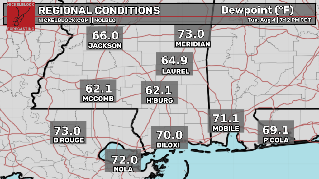
Winds along the coast are flipping to become southerly again. This will advect 70s dew points into our region. The heat will also come back with a vengeance. Highs may reach the upper 90s.
Rain chances will be low but not zero. While large scale ascent will be minimal, intense heating and surface convergence may be enough to initiate some isolated thunderstorms. These would be capable of very heavy rain and frequent lightning (along with a strong gust or two as they collapse) but nothing severe.

Tonight
While the northern portion of our area may have a pretty comfortable night, areas closer to the gulf will get engulfed in moisture.
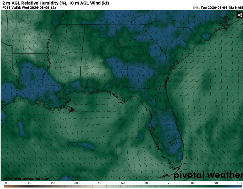
These areas may be susceptible to fog given a nearly saturated boundary layer. This will be most common south of I20 in low lying areas and river valleys. Use caution when encountering low visibility.
The good news is that any showers that are currently ongoing will quickly dissipate with the loss of daytime heating. Lows will be in the low to mid 70s. Cloud cover other than fog will be minimal.
Tomorrow
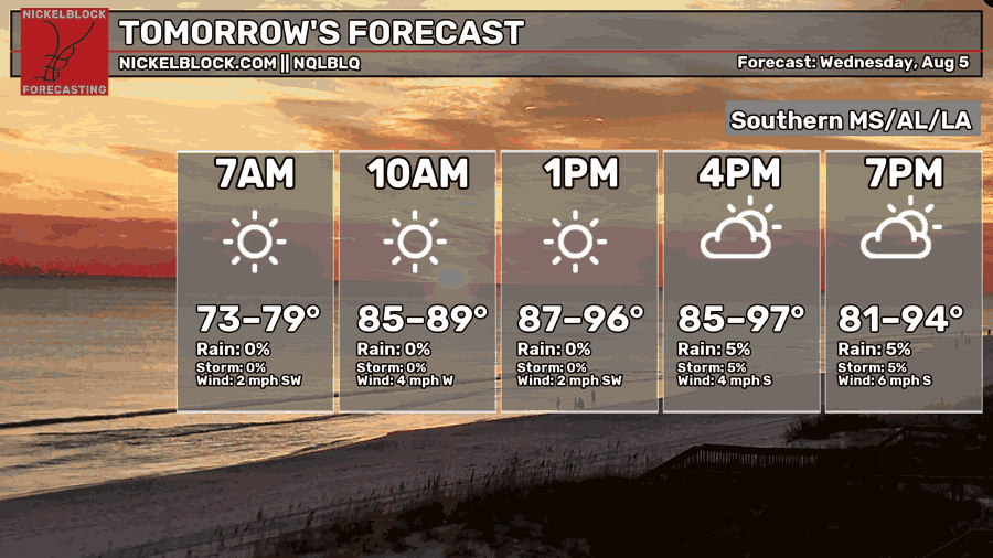
Pretty hot. But not just hot. Humid. When we get winds out of the south, the air gets soupy.
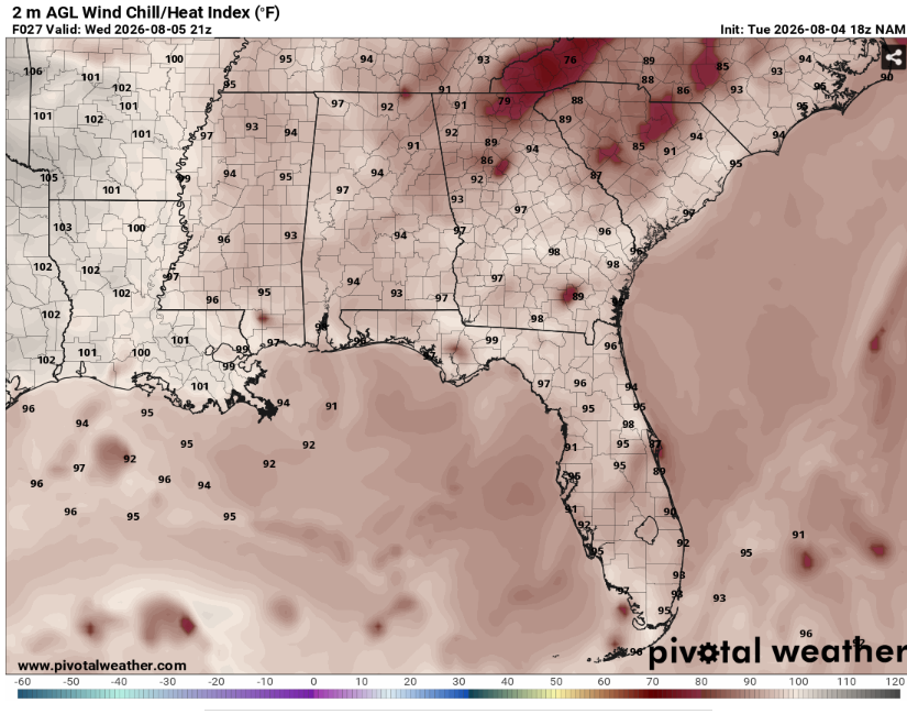
Heat indexes will likely exceed 100. Make sure to drink plenty of fluids and take breaks in the AC if you must be outside. Maybe a good day to go to the pool.
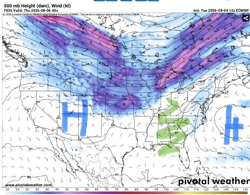
Our area will be sandwiched between two areas of high pressure with a very weak trough over the southern Appalachians. This will result in a stagnant pattern with minimal lift or shear for convection. That doesn’t mean everywhere will be dry but that most place will. For anywhere that does get rain, it’ll probably come down in buckets with lots of thunder given the expected slow moving nature of the storms.
Cloud cover will be low outside of areas of any convection.
Overall, a typical August day.

The Day After Tomorrow
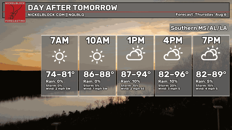
Rinse and repeat. Another hot and humid day. Highs will again be in the mid to upper 90s. A good day to stay inside during peak heating.
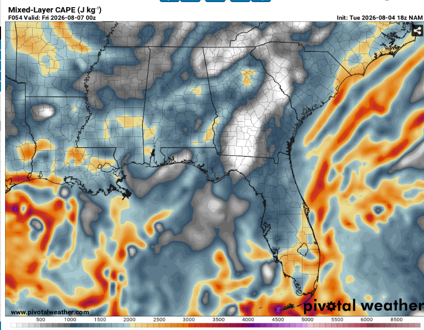
All that heat and moisture will lead to seasonably strong instability. This means that if a storm forms, it’ll have access to a lot of fuel. The question is whether or not a storm will form. Someone will probably get wet but it’s hard to pinpoint exactly who.
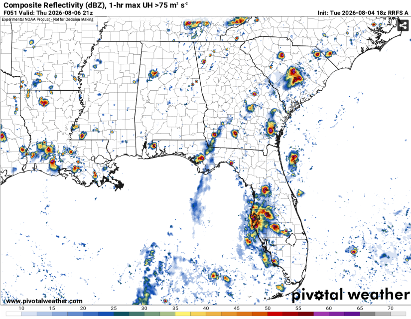
Any storms that do occur will be isolated and fairly benign given the nonexistent vertical wind shear. Just the usual heavy rain, gusty winds, some lightning.

The Extended Outlook
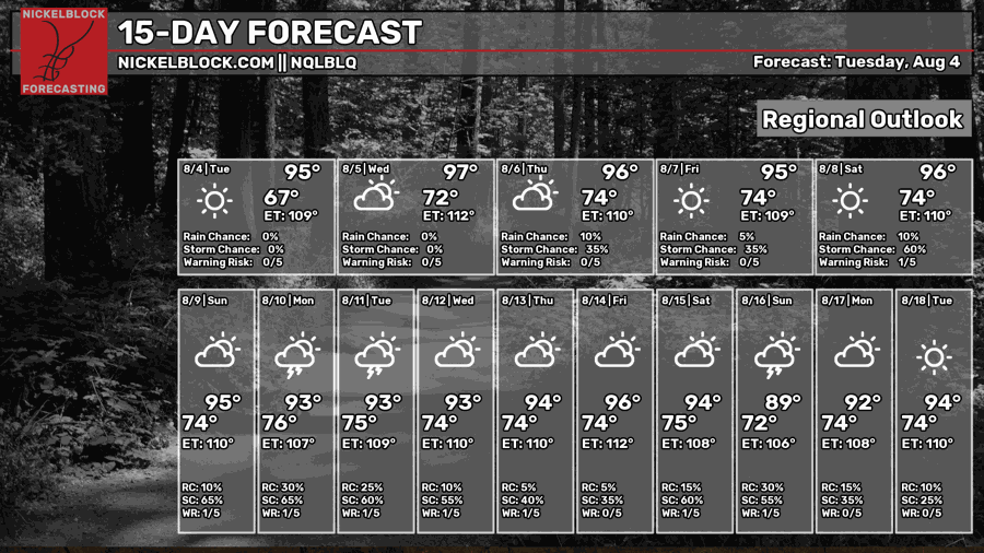
Unfortunately, summer looks to be flexing it’s muscles. The upcoming pattern looks pretty hot with our area remaining under ridging. Nothing historic but pretty unpleasant. Rain chances are a bit more uncertain.
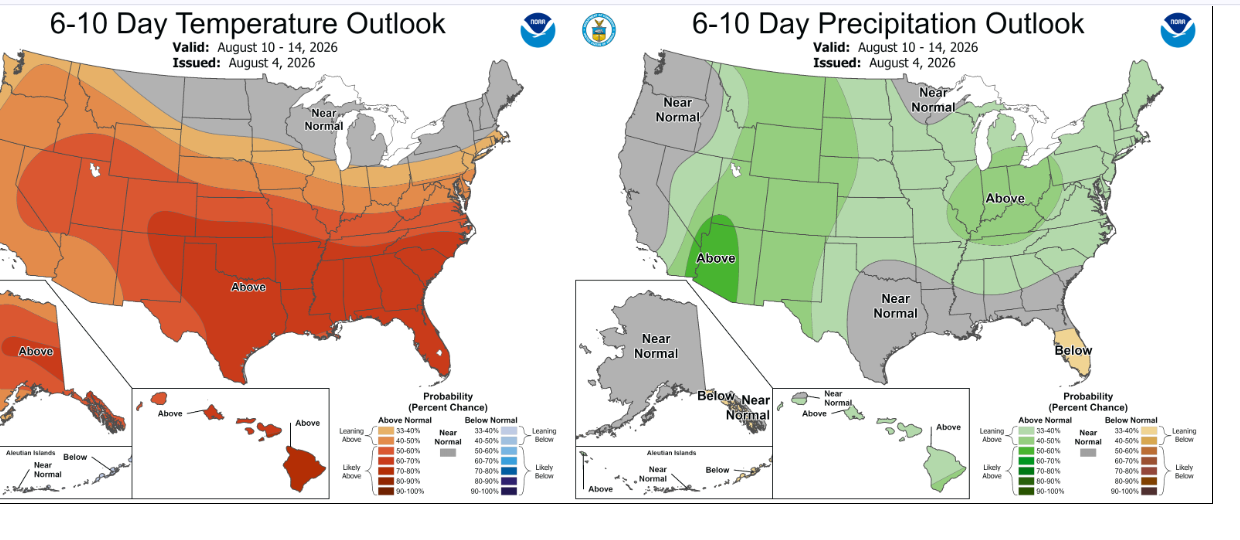
The Climate Prediction Center is really hitting the heating message hard. They have outlined the entire Gulf coast region in a slight risk of excessive heat with some areas in a moderate risk. This will be driven by very humid and warm nights and hot sunny days. Rain chances will mainly be hit or miss depending on where the afternoon thunderstorms occur.
Day-By-Day Forecast
Tonight- Mostly clear with a low in the low 70s. Rain fizzles out early with some fog possible near sunrise.
Tomorrow- Mostly sunny with a high in the mid 90s. Can’t rule out an isolated afternoon storm or two.
Tomorrow Night- Mostly clear with a low in the mid 70s. No rain but some fog is possible.
Thursday- Isolated afternoon thunderstorms possible. Mostly sunny with a high in the mid 90s.
Thursday Night- Mostly clear with a low in the mid 70s. No precip but probably fog.
Friday- Sunny with a high in the mid 90s. Dry.
Friday Night- Mostly clear with a low in the low 70s. No rain.
Saturday- Sunny with a high in the upper 90s. No precip expected.
Saturday Night- Partly cloudy but dry with a low in the mid 70s.
Sunday- Afternoon thunderstorms possible. Increasing clouds with a high in the mid 90s.
Sunday Night- Partly cloudy with a low in the mid 70s. No rain.
Monday- Scattered thunderstorms possible in the afternoon. Increasing clouds with a high in the mid 90s.
Monday Night- Partly cloudy but dry with a low in the mid 70s.


