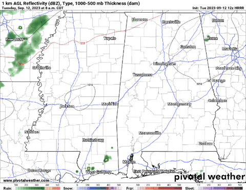
The shot for rain during the next 48 hours is looking a bit better – but still not great. The hi-res guidance came back this morning showing hit and miss showers and maybe a few storms this afternoon and evening and then again tomorrow morning. And perhaps even another shot on Thursday morning.
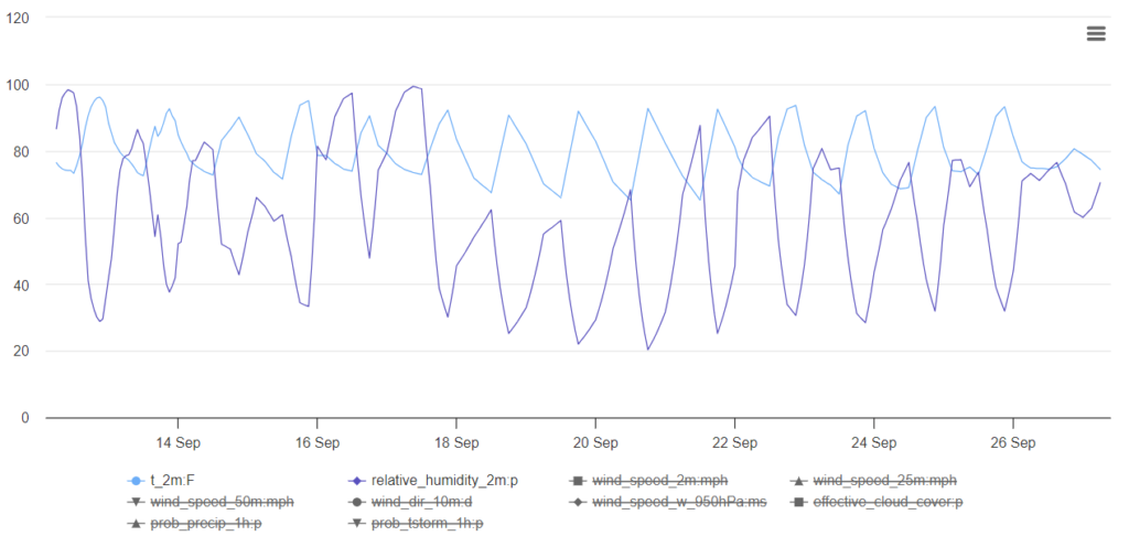
While there isn’t a “big” change on the way, it does look like things get a little less “dog days of summer like” as we move into next week. Overnight lows look to ease back into the upper 60s – for the entire week.
Now, the average high and low for this time of year is a high of 88 and a low of 68, so we should be closer to normal next week.
On the chart below, you can watch the temperatures undulate between around 70 and around 90 for the next 15 days. But we do lose a bit of humidity as we move through the early parts of next week, which should help us drop overnight lows into the 60s.
Looking out a bit further in time, at the 40-day model guidance for temperature a precip, things look to remain pretty warm
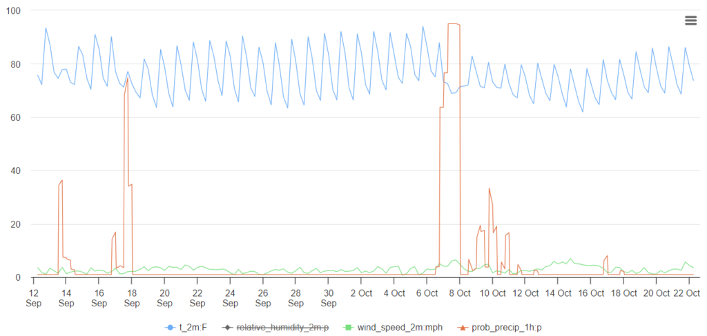
Keep in mind, these 40-day model runs are far less accurate (even in the short term) than the regular forecast. That is why it shows cooler temperatures during the next few days (which are not very likely). But I think it can give us a good general idea about what to expect during the next month or so.
And what the chart above say is, “prepare for continued warmth.”
It also shows a cool down finally coming – with some rain – as we get into the first week of October. So that may be something to keep on your radar in the coming weeks, too.
[wpcode id=”41149″]
REGIONAL DAY TO DAY FORECAST
Today: Mostly sunny with a chance of showers and thunderstorms. Highs in the lower 90s. Northwest winds around 5 mph, becoming southwest in the afternoon. Chance of rain 40 percent.
Tonight: Partly cloudy. A slight chance of showers and thunderstorms in the evening. Lows in the lower 70s. South winds around 5 mph in the evening, becoming light and variable. Chance of rain 20 percent.
Wednesday: Mostly sunny. A chance of showers and thunderstorms in the afternoon. Highs in the lower 90s. Northwest winds 5 to 10 mph. Chance of rain 30 percent.
Wednesday Night: Mostly cloudy. A slight chance of showers and thunderstorms in the evening. Lows in the upper 60s. North winds around 5 mph. Chance of rain 20 percent.
Thursday: Mostly sunny with a few storms possible. Highs in the lower 90s. Chance of rain 30 percent.
Thursday Night: Partly cloudy. Lows in the upper 60s.
Friday: Mostly sunny. A slight chance of showers and thunderstorms in the afternoon. Highs in the lower 90s. Chance of rain 20 percent.
Friday Night: Partly cloudy in the evening, then clearing. Lows in the upper 60s.
Saturday: Mostly sunny. A chance of showers and thunderstorms in the afternoon. Highs in the lower 90s. Chance of rain 30 percent.
Saturday Night: Partly cloudy with a slight chance of showers and thunderstorms. Lows in the upper 60s. Chance of rain 20 percent.
Sunday: Mostly sunny. A slight chance of showers and thunderstorms in the afternoon. Highs in the lower 90s. Chance of rain 20 percent.
Sunday Night: Partly cloudy. Lows in the upper 60s.
Monday: Sunny. Highs in the lower 90s.


When do you see it, in South MS, cooling off to daytime highs being in the 70s or lower 80s?
Looks like mid-October is probably the start of our slide back into the 70s and 80s this year. Hang in there!