
A couple of fronts have set up over the southern US forming a small cyclonic rain system. Many areas from eastern Texas and Arkansas to southern Alabama will see rain over the next 24 hours.
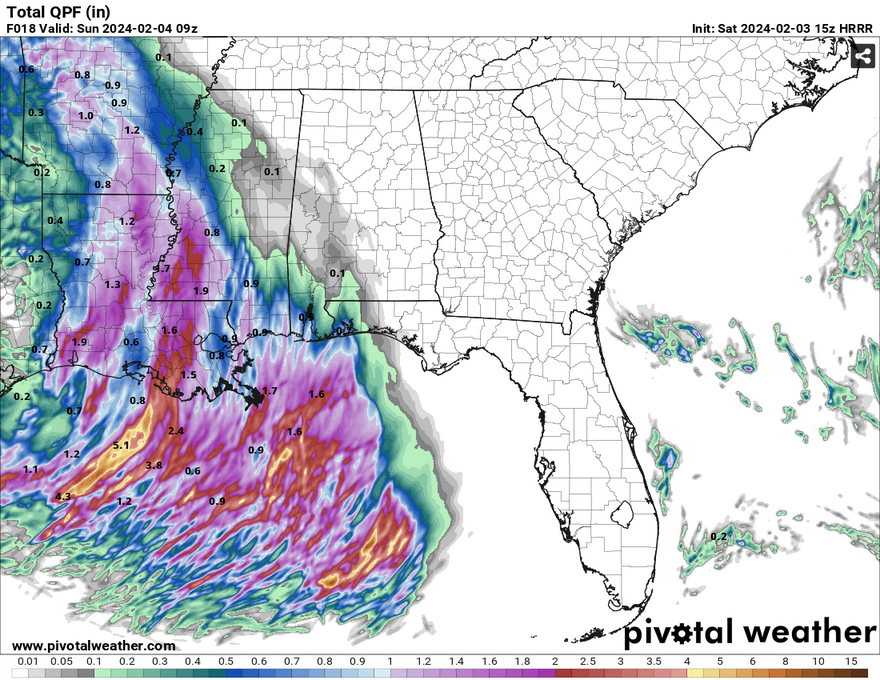
A subtropical jet has setup in the mid-levels which will feed moisture at a high rate of speed. The trough is also negatively tilted which will provide some stronger winds along with the heavy rain. The HRRR model shows heavier rain in southern Louisiana with the heaviest pockets closer to Lake Ponchtrain and the Mississippi Gulf coast. Rainfall amounts up to 5 inches are possible especially in areas closer to the coast.
Despite the heavy rain and wind, the other severe parameters are pretty low. This is mostly a flash flooding and wind related event. As the low pressure system reaches the deep south, it will hook off to the north before giving way to the system that was in east Texas. As that develops, our subtropical low will move south towards the Gulf of Mexico bringing rain to areas in southeast Alabama and the Florida panhandle.
What we need to know for the next 36 hours: Areas of southern Louisiana to southern Mississippi especially closer to the coast will receive heavy rain during the next 24 hours. Localized flash flooding is possible in low-lying areas and where a squall of rain will set up. Strong winds up to 40 mph are possible with this front especially areas closest to the low pressure system in southern Louisiana. Rainfall amounts will be from 1-5 inches across the board, however the heaviest rain looks to be around the Louisiana/Mississippi coast.
[wpcode id=”41179″]
Regional Day-to-Day Forecast
This Afternoon – Showers likely in the afternoon. Cloudy, with a high in the mid 60s. East southeast wind 10 to 15 mph, with gusts as high as 25 mph. Chance of precipitation is 60%. New precipitation amounts of less than a tenth of an inch possible.
Tonight – Showers and thunderstorms overnight. Low in the upper 40s. Windy, with an east southeast wind 20 to 25 mph decreasing to 15 to 20 mph after midnight. Winds could gust as high as 40 mph. Chance of precipitation is 100%. New rainfall amounts between 1 and 2 inches possible.
Sunday – Showers and thunderstorms likely until the afternoon. Mostly cloudy, with a high in the mid 60s. Southeast wind 5 to 10 mph becoming northwest in the afternoon. Chance of precipitation is 60%. New rainfall amounts between a quarter and half of an inch possible.
Sunday Night – A 50 percent chance of showers. Mostly cloudy, with a low in the low 40s. North wind 5 to 10 mph, with gusts as high as 20 mph. New precipitation amounts of less than a tenth of an inch possible.
Monday – Partly sunny, with a high near 60. North wind 10 to 15 mph, with gusts as high as 25 mph.
Monday Night – Mostly clear, with a low in the upper 30s. North wind 5 to 10 mph, with gusts as high as 20 mph.
Tuesday – Sunny, with a high in the mid 60s. North wind around 5 mph.
Tuesday Night – Mostly clear, with a low in the mid 30s. North wind around 5 mph becoming calm after midnight.
Wednesday – Sunny, with a high in the upper 60s. Calm wind becoming south southeast around 5 mph in the afternoon.
Wednesday Night – Mostly cloudy, with a low in the mid 40s.
Thursday – Mostly cloudy, with a high in the upper 60s.
Thursday Night – Mostly cloudy, with a low in the mid 50s.
Friday – A 20 percent chance of showers. Mostly cloudy, with a high near 70.
[wpcode id=”41149″]


