The Tropics decided that hurricane season would start on time, and with it, Tropical Storm Arlene has formed in the Gulf. But, to our surprise, it’s moving away from us! Even though it’s reached Tropical Storm status, it will begin to diminish back to a tropical depression in the next day or so. However, for people in Cuba and South Florida, they’ll still see the effects such as wind and flash flooding. For us, it’s kind of good news for this weekend.

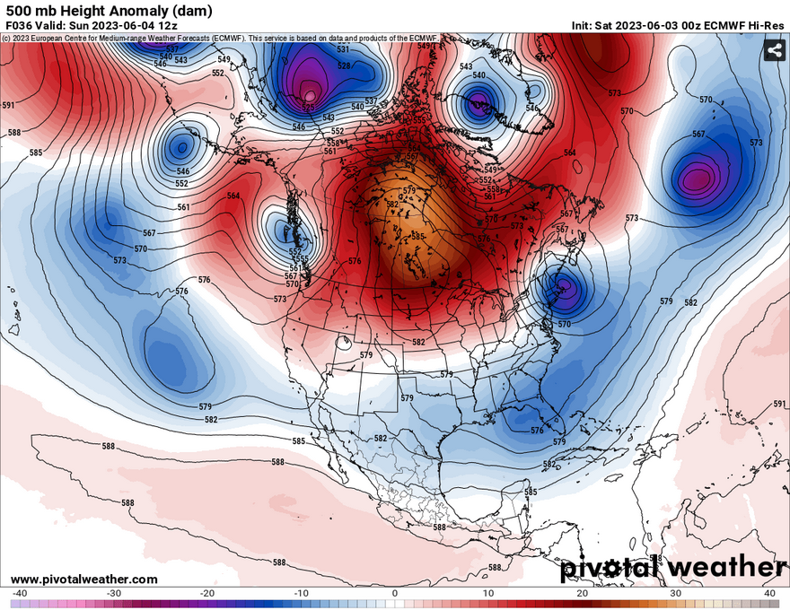
Currently, we’re in a bit of a lock between a couple of troughs and a massive ridge. One of the troughs is an upper level trough which is located on the eastern end of the Southeast. With it is the driving force pushing Arlene out to sea. Another trough, a closed low, is off the New England Coast and will begin to strengthen over the weekend. In between both of these is a massive Canadian Ridge.
While the northeastern winds are blowing in the mid-levels keeping the relative humidity down in the boundary layer, this doesn’t mean that we won’t see a possible afternoon thunderstorm. Most of them will be isolated, fairly unorganized and will be limited in strength. Sunday will be a similar story, however the northeast winds will push a few more storms towards us in the afternoon. Overall, this weekend will be hot and humid with highs in the low 90s.
[wpcode id=”41179″]
Regional Day-to-Day Forecast
Today – A 30 percent chance of showers and thunderstorms in the mid-afternoon. Sunny, with a high in the low 90s. North northeast wind around 5 mph.
Tonight – A 10 percent chance of showers and thunderstorms before sunset. Mostly clear, with a low in the mid 60s. North wind around 5 mph becoming calm.
Sunday – Sunny, with a high in the low to mid 90s. Winds east northeast 5 to 10 mph.
Sunday Night – Mostly clear, with a low in the mid 60s. East southeast wind around 5 mph becoming calm in the evening.
Monday – A 50 percent chance of showers and thunderstorms in the early afternoon. Mostly sunny, with a high in the lower 90s. Southeast wind around 5 mph. New rainfall amounts of less than a tenth of an inch, except higher amounts possible in thunderstorms.
Monday Night – Partly cloudy, with a low in the mid 60s. South southeast wind around 5 mph.
Tuesday – A 40 percent chance of showers and thunderstorms in the early afternoon. Mostly sunny, with a high in the low 90s. Southwest wind around 5 mph.
Tuesday Night – Partly cloudy, with a low in the upper 60s. Southwest wind around 5 mph.
Wednesday – A 40 percent chance of showers and thunderstorms in the early afternoon. Mostly sunny, with a high in the low 90s. West wind around 5 mph.
Wednesday Night – Partly cloudy, with a low in the mid 60s.
Thursday – A 30 percent chance of showers and thunderstorms. Mostly sunny, with a high near 90.
Thursday Night – A 20 percent chance of showers and thunderstorms. Partly cloudy, with a low in the mid 60s.
Friday – A 30 percent chance of showers and thunderstorms. Mostly sunny, with a high in the upper 80s.
[wpcode id=”41149″]


