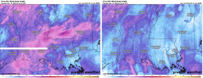
Today, a closed low pressure system is traversing eastward across the Great Plains, inducing breezy southeast to south winds across the area. This pattern encourages the influx of moisture, fostering isolated to scattered showers and thunderstorms, particularly northwest of us, but I suppose we can’t completely rule out a shower.
Afternoon temperatures are expected to reach the low to mid 80s, with overnight lows remaining seasonably warm, ranging from the mid to upper 60s east of I-55 to the low 70s northwest. Meanwhile, a cold front is projected to advance into northern Mississippi overnight, amplifying rain chances for areas north of I-20.

As we approach late week into the weekend, the region’s meteorological landscape becomes defined by the northern periphery of an upper ridge extending from the Bay of Campeche. This setup promotes persistent westerly zonal flow, resulting in a stationary frontal boundary gradually descending southward. Consequently, multiple rounds of rain and storms are anticipated, with isolated severe storms not out of the question.
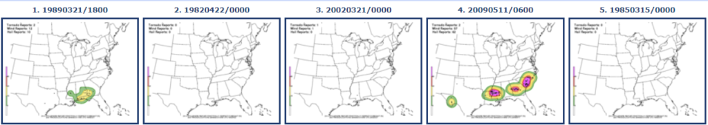
That said, historically, these types of situations are not big “severe” producers. Looking at the CIPS Analogs data for Saturday, we see that 2 of the Top 5 most similar situations produce severe weather regionally. And the most recent time that happened was 2009.
By Monday, temperatures may moderate slightly, offering a brief reprieve from the warmth with seasonably cool conditions.
REGIONAL DAY TO DAY FORECAST
Today: Mostly sunny this afternoon after some clouds and drizzle this morning. Highs in the lower 80s. South winds 10 to 15 mph with gusts up to 25 mph. Chance for rain less than 10 percent.
Tonight: Mostly cloudy. Lows in the mid 60s. South winds 10 to 15 mph with gusts up to 25 mph, diminishing to around 5 mph after midnight.
Wednesday: Mostly cloudy. More drizzle and light rain possible. Highs in the lower 80s. South winds 10 to 15 mph. Chance for rain around 10 percent.
Wednesday Night: Mostly cloudy. Lows in the mid 60s. South winds 5 to 10 mph.
Thursday: Mostly cloudy. Highs in the mid 80s. South winds 5 to 10 mph.
Thursday Night: Mostly cloudy. Lows in the mid 60s.
Friday: Mostly sunny. Can’t rule out a shower or storm. Highs in the upper 80s. Chance for rain around 20 percent.
Friday Night: Partly cloudy in the evening, then becoming mostly cloudy. Lows in the mid 60s.
Saturday: Mostly cloudy in the morning, then partly sunny with a slight chance of showers and thunderstorms in the afternoon. Highs in the mid 80s. Chance of rain 40 percent.
Saturday Night: Mostly cloudy. A slight chance of showers and thunderstorms after midnight. Lows in the lower 60s. Chance of rain 40 percent.
Sunday: Mostly cloudy with a chance of showers and thunderstorms. Cooler with highs in the mid 70s. Chance of rain 60 percent.
Sunday Night: Mostly cloudy in the evening, then becoming partly cloudy. Cooler with lows in the lower 50s.
Monday: Mostly sunny. Highs in the upper 70s.


