We’ve got a breezy few days in store as the next system slides by to the north. We are going to be sandwiched in-between a big ridge to our south (warm!) and a system gliding by to the north (storms) and that should do enough to really kick up the wind during the next few days.
Here is a look at some of the peak potential wind gusts. This isn’t going to be the sustained wind speed, but gusts up to 40mph will be possible at times. Sustained wind will be between 15mph and 25mph at times, though, today and tomorrow before things calm down on Thursday.
While the wind will be rather annoying, I think we will all happily take some breezy conditions over the threat for severe weather! Once the wind eases back, it’ll go right back to just plain old warm through the rest of the week and weekend.
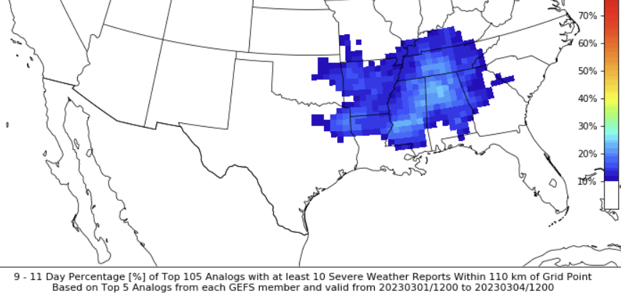
Right now, it looks like next week will be the next chance for storms. The CIPS Analogs continue to highlight the region with the potential for storms by the 27th/28th/1st window.
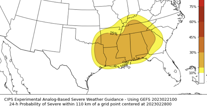
There is still a fair bit of uncertainty here. This looks similar to what we were seeing for tomorrow a week ago. And now tomorrow doesn’t look quite as bad. So this may also shake out the same way. Or not. That is always the tough part about forecasting these events so far out, things can get tricky when there isn’t a BIG sign pointing toward a big threat.
That said, when I looked a bit deeper into the CIS data, it did suggest the higher risk for storms was a bit farther north.
So this all bears watching in the coming days. But for now, enjoy the warmth! Just hold onto your hat with all this wind…
REGIONAL DAY TO DAY FORECAST
Today
Mostly cloudy this morning, then becoming partly sunny. Highs in the upper 70s. Southwest winds 10 to 15 mph with gusts up to 25 mph.
Tonight
Mostly cloudy. Lows in the lower 60s. South winds 10 to 15 mph with gusts up to 25 mph.
Wednesday
Partly sunny. Highs around 80. South winds 15 to 25 mph with gusts up to 40 mph closer to I-20 and northward.
Wednesday Night
Mostly cloudy. Lows in the upper 60s. South winds 15 to 20 mph with gusts up to 30 mph.
Thursday
Mostly cloudy in the morning, then becoming partly sunny. Highs in the mid 80s. South winds 10 to 15 mph.
Thursday Night
Mostly cloudy. Patchy fog after midnight. Lows in the mid 60s.FridayPatchy fog in the morning. Cloudy. Highs in the upper 70s.
Friday Night
Mostly cloudy. Lows in the lower 60s.
Saturday
Mostly cloudy in the morning, then becoming mostly sunny. Highs in the lower 80s.
Saturday Night
Mostly cloudy. Lows in the lower 60s.
Sunday
Mostly cloudy in the morning, then becoming mostly sunny. Highs in the lower 80s.
Sunday Night
Partly cloudy in the evening, then becoming mostly cloudy. Lows in the lower 60s.
Monday
Mostly cloudy in the morning, then partly sunny with a chance of showers with a slight chance of thunderstorms in the afternoon. Highs in the lower 80s. Chance of rain 40 percent.


So, I guess I’ll be wishing you a Happy Windsday tomorrow?