Now that the rain is gone, we can focus on the cooler temperatures and nice conditions. Today, highs will top out in the 50s and 60s across the region. Should be a cool, crisp Spring day. Then overnight tonight things get pretty chilly. Overnight lows down into the 30s in most spots.

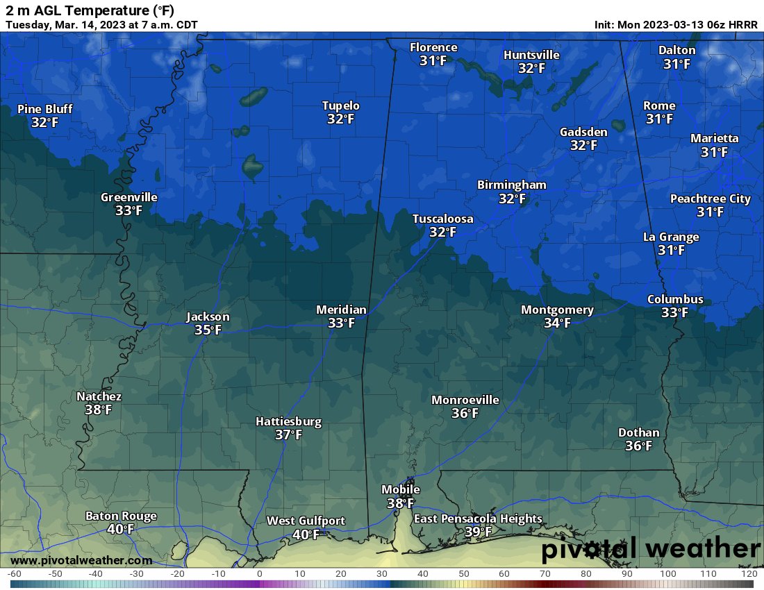
The threat for a frost will be mostly confined to places along I-20 and to the north. But a few spots as far south as the HWY 84 corridor may see a frost, if they are in low-lying and sheltered areas. The wind will be the main thing to keep any frost at bay tonight. A breeze around 3mph to 5mph may do juuuuust enough overnight to keep ice from forming on all of the new plants that have sprouted.
Also, since I know many of the Pecan trees have budded out, this just goes to show that those trees can’t predict the end of frosty weather.
The chilly overnight temperatures may return for Wednesday morning, too, for some folks along and north of I-20. Everywhere else, temperatures will likely bottom out close to 40.
Then we start watching for the next storm system set to push through later this week.


So far it looks like Friday will be the day for storms across the region as the next cold front slides through. Early data suggests that a few severe thunderstorms may be possible, but it is still a bit early for specifics. This may be another case where we watch for “the blob” of storms to develop in the Gulf of Mexico near the coast to eat up all the low-level moisture.
That said, the last few times we have been watching for “the blob” it has never materialized. It is something to hope for, yes. But I wouldn’t put money on it.
Once this cold front kicks through we will get a break over the weekend and then the next system looks to move through early next week.
REGIONAL DAY-TO-DAY FORECAST
Today
Mostly sunny. Cooler with highs in the mid 60s. North winds 10 to 15 mph with gusts up to 25 mph.
Monday Night
Mostly clear. Lows in the upper 30s. North winds around 5 mph.
Tuesday
Mostly sunny. Highs in the lower 60s. North winds around 10 mph.
Tuesday Night
Partly cloudy. Lows in the upper 30s. Northeast winds around 5 mph.
Wednesday
Sunny. Highs in the mid 60s.
Wednesday Night
Clear. Lows in the lower 40s.
Thursday
Sunny. Highs in the mid 70s.
Thursday Night
Partly cloudy. Lows in the upper 50s.
Friday
Showers and storms possible. Some severe. Highs in the mid 70s. Chance of rain 70 percent.
Friday Night
Mostly cloudy with lingering showers possible. Lows in the mid 40s. Chance of rain 40 percent.
Saturday
Mostly sunny. Much cooler with highs around 60.
Saturday Night
Partly cloudy in the evening, then becoming mostly cloudy. Lows in the lower 40s.
Sunday
Mostly sunny. Highs in the upper 50s.


