Happy Thursday! I hope everyone is settling back into the week after hopefully a long weekend. Today’s look into the southeast weather forecast is going to feature hot temperatures and a look at the chances for storms over the next couple of days.

The story for today is extreme heat with temperatures well above 100F for much of Texas with 90s being the story from Louisiana to Georgia. Due to this extreme heat, the NWS has issued heat advisories and extreme heat warnings for much of the southeast through 9PM on Thursday.

This map shows heat advisories in effect for much of the southeast including the cities of Dallas, Little Rock, and Birmingham. The heat advisory is issued for excessive periods of heat indices at or near 105F. Portions of northwestern Mississippi and western Tennessee including Memphis are under a more severe excessive heat warning, where heat indices could be at or above 110F.
Unfortunately, this heat is likely to stick around, as we see anomalously high 850MB temperatures due to a ridge being centered over the southeast. These anomalously high 850MB temperatures correlates to hotter than normal temperatures down at the surface, prompting the heat advisories and warnings.

The red coloring on the map throughout much of the southeast is easy to pinpoint and displays where the hot weather will continue to be throughout the rest of the week and into the weekend.
Looking at the 3-day precipitation forecasts, most of the precipitation will be centered farther away from the upper-level ridge, where showers and thunderstorms are more likely to fire off under more northwesterly flow.
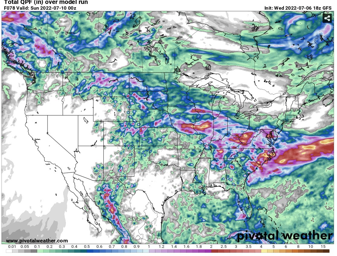
Looking at the potential precipitation through Saturday night, areas from Texas through Louisiana, Mississippi, and Alabama will remain mostly dry, with higher precipitation amounts expected in Georgia and Tennessee.
In fact, the SPC has also highlighted this possibility in their severe weather outlook, where the more substantial risks for severe weather are expected further to the east and northern portions of the southeast US.

As the graphic indicates, the risk for more severe and substantial weather is over Tennessee and portions of Georgia and Alabama. Despite these higher risks, the main concerns from these storms will be heavy rain and damaging wind gusts, as tornadoes are not likely from these storms.
3-Day Southeast City Forecast
| Dallas, TX | ||
| Thursday | Friday | Saturday |
| High: 103 | High: 105 | High: 105 |
| Low: 82 | Low: 83 | Low: 82 |
| Precip: None | Precip: None | Precip: None |
| Houston, TX | ||
| Thursday | Friday | Saturday |
| High: 96 | High: 97 | High: 98 |
| Low: 79 | Low: 80 | Low: 81 |
| Precip: 20% | Precip: None | Precip: None |
| New Orleans, LA | ||
| Thursday | Friday | Saturday |
| High: 91 | High: 92 | High: 92 |
| Low: 79 | Low: 79 | Low: 80 |
| Precip: 50% | Precip: 50% | Precip: 50% |
| Little Rock, AR | ||
| Thursday | Friday | Saturday |
| High: 100 | High: 101 | High: 99 |
| Low: 81 | Low: 81 | Low: 76 |
| Precip: None | Precip: None | Precip: 30% |
| Memphis, TN | ||
| Thursday | Friday | Saturday |
| High: 100 | High: 101 | High: 97 |
| Low: 81 | Low: 80 | Low: 75 |
| Precip: 20% | Precip: 20% | Precip: 50% |
| Birmingham, AL | ||
| Thursday | Friday | Saturday |
| High: 96 | High: 97 | High: 95 |
| Low: 77 | Low: 77 | Low: 73 |
| Precip: 40% | Precip: 30% | Precip: 60% |
| Atlanta, GA | ||
| Thursday | Friday | Saturday |
| High: 93 | High: 93 | High: 92 |
| Low: 76 | Low: 76 | Low: 73 |
| Precip: 50% | Precip: 50% | Precip: 70% |


