Some folks picked up some rain overnight. Not a ton, but enough to probably pull some of the dust and pollen out of the air and give the plants a sip to drink.
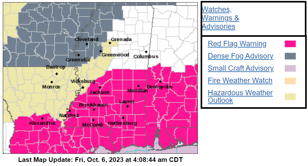
Behind that front, we’re in for some cooler air, the coolest we’ve had since May. But what really matters is how dry it’s gonna get. Dewpoint values will be tumbling down into the 40s and 30s (even 20s in some spots on Saturday). That, combined with the wind picking up, means there’s a higher risk of wildfires, especially if we don’t get much rain. So, be careful out there. Please avoid any outdoor burning.
Model guidance seems to be oddly convinced that moisture from two (yeah, two!) tropical systems in the Pacific will somehow try to traverse Mexico and plop into the Gulf and along the Gulf Coast, offering us a shot for rain late next week and into next weekend. I’m not fully sold on this, even though it is shown across a few models. While I think there is likely some weight to ‘some sort of something’ happening that looks similar, I don’t think it will play out as shown.
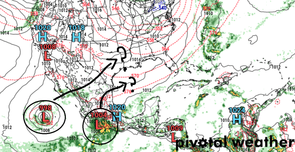
As an aside, this can happen in the model guidance where some models show a general trend toward a similar outcomes, but none are accurate. We (meteorologists) sit here, thinking, “Okay, so the idea of something like this is possible, but it won’t actually look like this when it is all said and done.” and then we have to find all of the puzzle pieces and background ingredients that are going into the forecast to make the models do what they are doing — and from there, we can usually get a good idea as to what may happen.
Currently, we are still in the ‘looking at puzzle pieces and background forecast info’ stage.
[wpcode id=”41149″]
REGIONAL DAY TO DAY FORECAST
Friday: Morning clouds with some lingering rain possible then clearing. Highs in the mid 80s. Chance for rain around 30 percent. North winds 5 to 10 mph.
Friday Night: Mostly cloudy. Lows around 60. North winds 10 to 15 mph.
Saturday: Mostly sunny. Cooler. Less humid with highs in the mid 70s. North winds around 15 mph with gusts up to 25 mph.
Saturday Night: Partly cloudy. Cooler with lows in the upper 40s. North winds 5 to 10 mph.
Sunday: Sunny. Highs in the mid 70s.
Sunday Night: Mostly clear. Lows in the upper 40s.
Columbus Day: Sunny. Highs in the lower 80s.
Monday Night: Mostly clear. Lows in the mid 50s.
Tuesday: Mostly sunny. Highs in the mid 80s.
Tuesday Night: Partly cloudy in the evening, then becoming mostly cloudy. Lows around 60.
Wednesday: Mostly sunny. Highs in the mid 80s.
Wednesday Night: Mostly cloudy. A slight chance of showers after midnight. Lows in the mid 60s. Chance of rain 20 percent.
Thursday: Partly sunny with a chance of showers with a slight chance of thunderstorms. Highs in the lower 80s. Chance of rain 30 percent.


