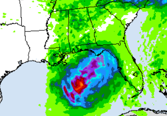
All eyes are on the tropical disturbance, Invest 91-L, in the eastern Gulf. However, let’s not overlook the scorching heat! It will be very hot, with highs easily reaching the upper 90s. The unforgiving sun and sweltering humidity will make being outdoors very uncomfortable, with heat index values feeling closer to 108–112. Check on friends and family, keep pets out of the heat, and find somewhere cool if you can.
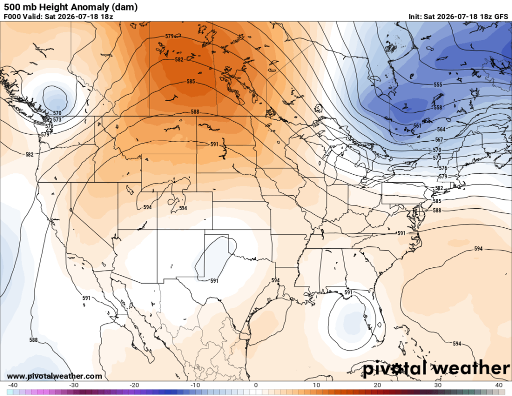
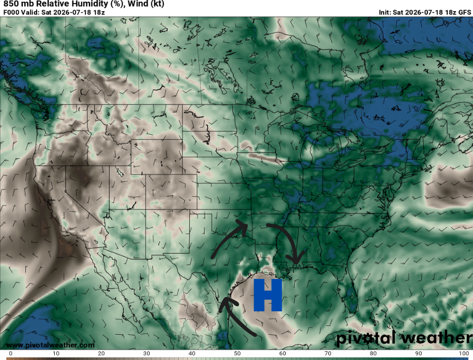
This is all brought about by the suppressive nature of the ridge overhead, helping keep things dry. At the same time, high pressure over the western Gulf is circulating tropical moisture back into the region with its clockwise flow, driving humidity even higher. The likely result will be the hottest temperatures we’ve seen so far this summer.
How next week starts depends on what that tropical disturbance in the eastern Gulf decides to do. If it takes a more northerly track toward the Florida Panhandle, heat will likely become a major issue for us, with heat warnings possible. However, if it tracks farther west toward southeastern Louisiana, we can expect more widespread rain. Be sure to check back as we watch the system’s path evolve over the weekend. An Air Force Reserve Hurricane Hunter aircraft is scheduled to investigate the system on Sunday if needed…pretty cool!

TONIGHT
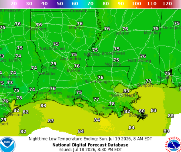
Clear skies. Staying warm tonight, with temperatures around 76 near Hattiesburg to 80 near Houma. Light northwest breeze around 5 mph.
TOMORROW
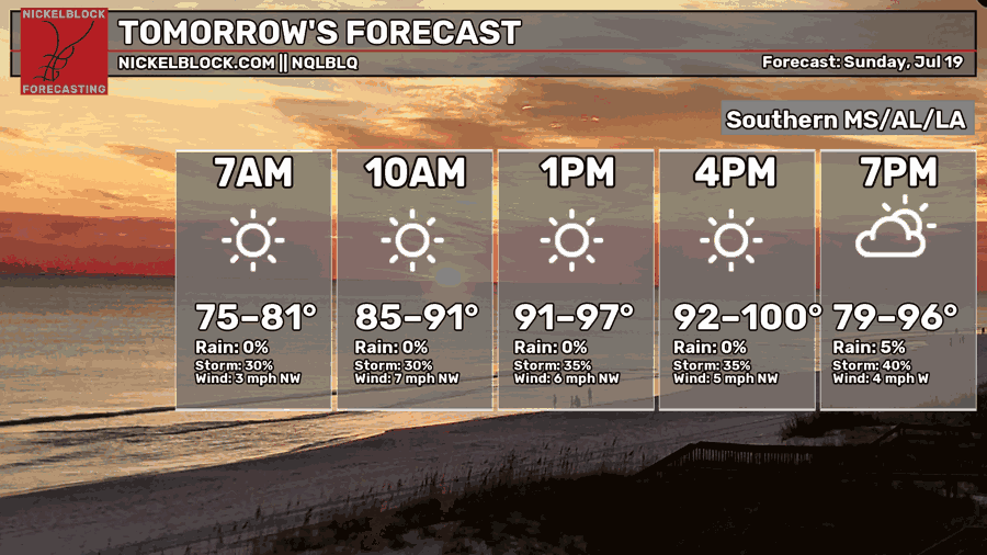
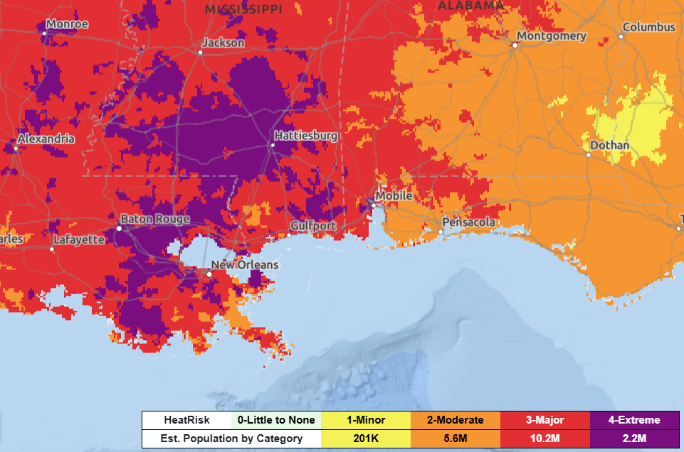
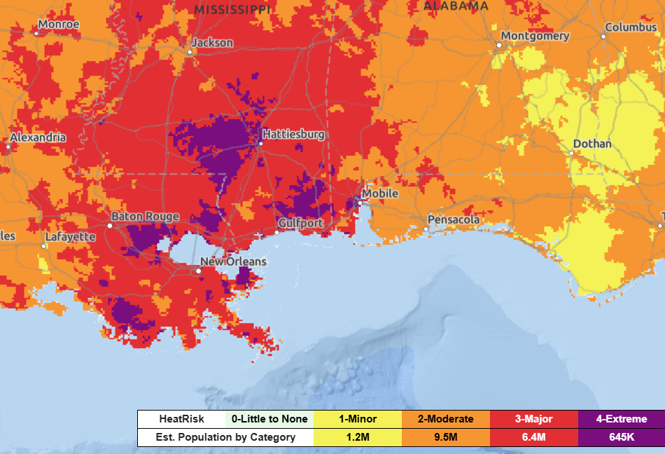
Sunday, a Heat Advisory is in effect until 6pm. It’s going to be a hot one! Apparent temperatures will soar to 110 in some spots due to the high humidity. Areas shaded in purple below are under an Extreme Heat Risk.
Staying sunny for most. Scattered thunderstorms are possible along and east of I-55 during the late afternoon hours. With plenty of heat and moisture around acting as fuel, some storms could be strong, producing wind gusts up to 40 mph and heavy rainfall.

THE DAY AFTER TOMORROW
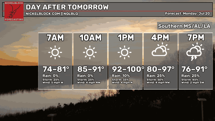
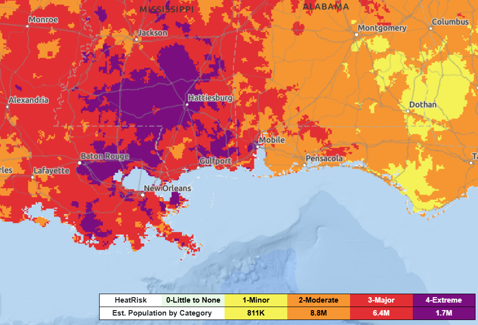
Monday, another scorcher! Highs easily reaching 100 during the afternoon. A Heat Advisory is in effect, with it feeling closer to 105–110. Mostly sunny skies, with scattered showers and thunderstorms possible during the late afternoon.
Rain coverage depends heavily on the track of the weak low-pressure system over the Gulf. As of now, most models keep the highest shot for rain across coastal Mississippi and southeastern Louisiana.

EXTENDED OUTLOOK
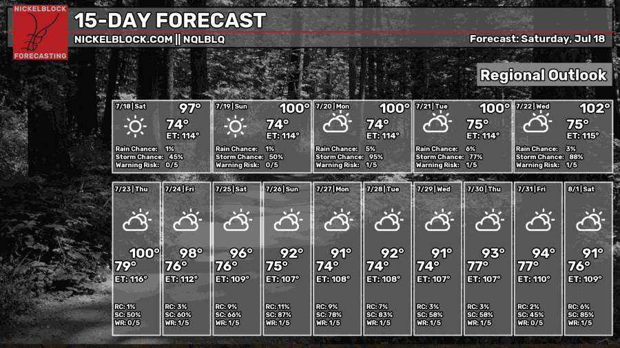
Looking ahead, this may be the hottest stretch we’ve seen all summer. Highs will easily reach the triple digits, with widespread heat index values around 105–115. Isolated to scattered showers and storms are expected to develop each afternoon over the next few days.
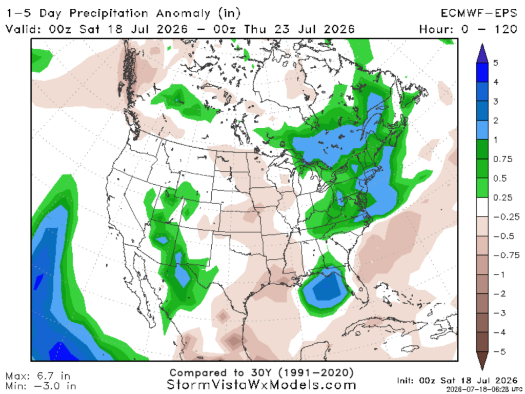
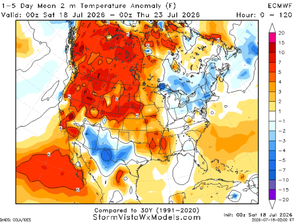
As of now, models show above-normal precipitation for our friends in Alabama and Florida. Meanwhile, we are forecasted to see below-normal precipitation and above-normal temperatures. But hey… it is indeed summer after all!
DAY-BY-DAY FORECAST
Tonight – Clear skies. Staying warm tonight with temperatures around 76 near Hattiesburg to 80 near Houma. Light breeze from the northwest at 5mph.
Sunday – Heat advisory in place for highs near 100, with heat indices up to 110. Sunny skies with a light breeze from the north at 5–10 mph. Scattered showers are possible in the late afternoon across southern Mississippi, around 30%, decreasing to 5% farther west near Baton Rouge.
Sunday Night – A few showers and storms may linger around until 11pm before becoming dry and partly cloudy. Low around 77 with calm winds. Rain chance: 20%
Monday – Sunny and HOT! Heat advisory in effect for highs around 100, may feel like 105-110 degrees. Scattered storms in the late afternoon possible for mainly coastal Mississippi and southeastern Louisiana. Light breeze from the north at 5mph. Rain chance: 20%
Monday Night – A few showers and storms may linger overnight before giving way to clear skies. Low near 77. Rain chance: 20%
Tuesday – Heat and humidity continue building with highs near 100, but experienced temperature of 110. Scattered showers and thunderstorms possible in the afternoon, mainly along the coast. Northwesterly winds at 5mph. Rain chance: 30%
Tuesday Night – A few showers and storms may linger overnight before giving way to clear skies. Low near 77. Rain chance: 20%
Wednesday – Another scorcher. Daily temperature soaring to 100, but it will feel 10 degrees warmer. Sunny with a west wind around 5mph. Afternoon isolated storms possible along the coast. Rain chance: 20%
Wednesday Night –A few showers and storms may linger overnight before settling into a party cloudy night. Low near 77. Rain chance: 20%
Thursday – Sunny and hot, with highs approaching triple digits. A slight chance of showers and thunderstorms, mainly after 1pm. Light breeze from the northwest. Rain chance: 20%
Thursday Night – Mostly clear, with a low around 75. Calm wind.
Friday – A chance of afternoon showers and thunderstorms. Another hot day with highs near 96. Mostly sunny skies and light breeze from the north. Rain chance: 20%
Friday Night – Partly cloudy, with a low around 75. Calm wind.


