Howdy!
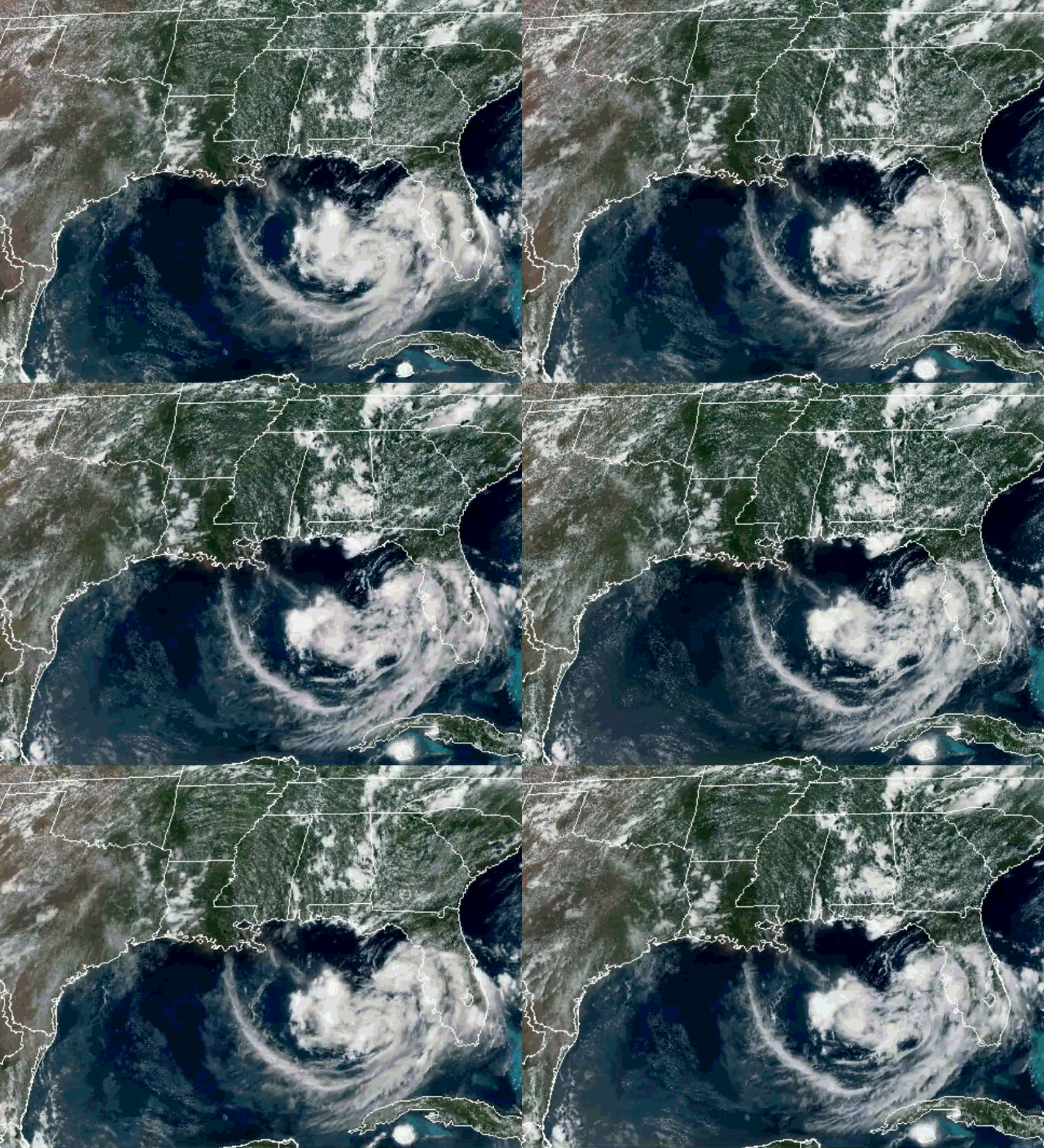
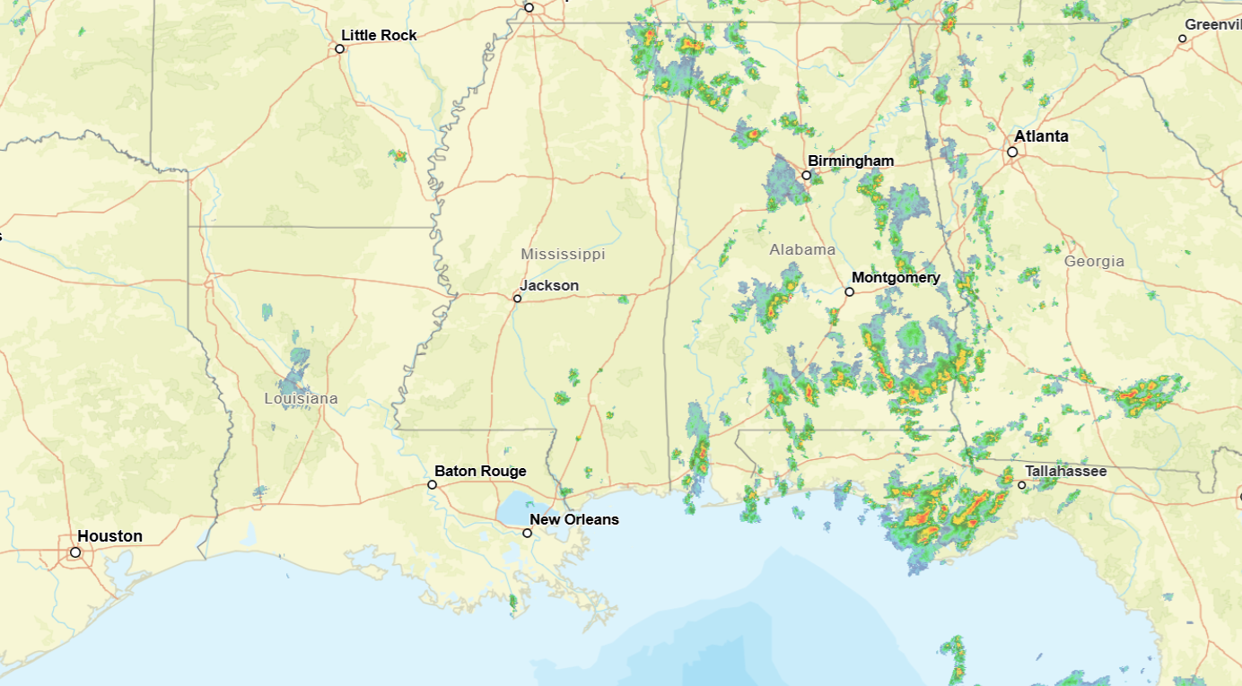
Currently, it looks like Alabama is getting the most rain with some scattered showers throughout the state, a little bit of cloud coverage for the area. The broad area of showers and thunderstorms over the gulf might turn into something, the NHC marking it as an area of interest.
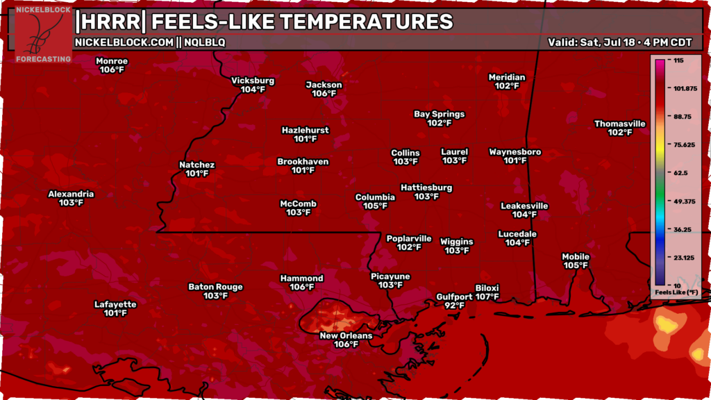
It is looking to be a hot day already! Feels-like temperatures reaching above 100 for much of the region. So keep hydrated when outside today, this heat is no joke.
The National Hurricane Center has marked the area off the coast of southern Florida as a 40% chance for tropical cyclone development, mainly having the possibility of developing into a tropical depression. This system is bringing with it moisture that is supporting the chance to see scattered showers and thunderstorms for the next couple of days before upper-level ridging moves and takes over once again, keeping chances of rain limited.
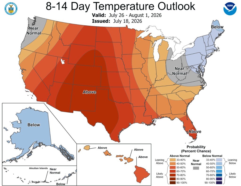
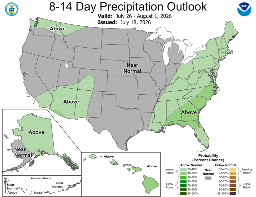
For the next 8-14 days, the Climate Prediction Center has stated that temperatures will remain above normal and so will the precipitation trends. While precipitation might be above normal, it is clear it will not provide much of any relief from the heat, so make sure to take care of yourself (and maybe go swimming if you can)!.
3-DAY TRAVEL FORECAST
AIRPORTS
KIAH/KHOU (Houston) – No weather-related delays are anticipated. A slight chance for showers and thunderstorms exists this afternoon, but not significant enough for any delays.
KSHV (Shreveport) – No weather-related delays are anticipated.
KBTR (Baton Rouge) – No weather-related delays are anticipated.
KJAN (Jackson) – No weather-related delays are anticipated.
KMSY (New Orleans) – No weather-related delays are anticipated. Isolated showers and thunderstorms are possible tomorrow and Monday night, but no impacts to aviation are expected.
KMOB (Mobile) – A chance of precipitation exists each day, with greatest chance for flight delays tomorrow through Monday afternoon due to lightning and possible strong winds.
KATL (Atlanta) – A slight chance of showers and thunderstorms exists each day and night, but no major impacts to aviation is anticipated.
KTLH (Tallahassee) – Delays due to lightning are possible each day and night.
KBHM (Birmingham) – Brief delays due to lightning are possible today through Monday afternoon, but no significant impacts are expected.
HIGHWAYS
I-10 – Scattered showers and thunderstorms are possible each day, starting this afternoon. Greatest chance of rain for the eastern portions of the region. If traveling in this direction, be careful as any possible thunderstorm could be strong.
I-20 – Today is looking to be mostly clear, though an isolated shower or thunderstorm cannot be ruled out. Greatest chance for rain exists tomorrow afternoon, especially more in MS and AL. Afternoon chances of showers and thunderstorms for Monday as well.
I-49 – Isolated showers and thunderstorms are possible each day, with tomorrow having the greatest chance for thunderstorms in southern Louisiana. Be cautious of this and drive safe.
I-55 – Isolated to scattered showers and thunderstorms are possible each day with greatest chance for thunderstorms tomorrow afternoon. Today and Monday ar looking to be better travel days.
I-59 – Isolated to scattered showers and thunderstorms are possible each day with greatest chance for thunderstorms tomorrow afternoon, some of which could be strong and produce some strong winds. Today and Monday are better travel days, but still be cautious!
I-65 – Scattered showers and thunderstorms are possible each day more in the afternoon, some thunderstorms could be strong and produce heavy rain/winds. Be cautious when driving for the next few days.
I-75 – Scattered showers and thunderstorms are possible each day more in the afternoon, some thunderstorms could be strong and produce heavy rain/winds. Most of the chance more in central/northern Georgia. Be cautious when driving for the next few days!
CITY FORECASTS
Houston, TX
Today/tonight – The high today will be near 95 with heat index values as high as 105. A 20% chance of showers and thunderstorms exists in the afternoon. Tonight, partly cloudy skies and a low around 76.
Tomorrow – Mostly sunny skies with a high near 96 and heat index values reaching 102. Tomorrow night, mostly clear skies with a low around 74.
Monday – Sunny and hot conditions, a high in the upper 90s. For Monday night, mostly clear skies with a low in the mid 70s.
Shreveport, LA
Today/tonight – Hot conditions today, mostly sunny skies with a high near 95. Mostly clear skies for tonight and a low around 76.
Tomorrow – Another sunny and hot day! The high will be near 97 and the low around 76, with clear skies for tomorrow night.
Monday – Sunny and hot day with a high in the upper 90s and a low in the mid to upper 70s. Clear skies for Monday night.
Baton Rouge, LA
Today/tonight – A heat advisory is in effect until 6:00pm this evening. Sunny and hot conditions with a high near 95 and heat index values reaching over 100. Tonight, mostly clear with a low around 76.
Tomorrow – A heat advisory will be in effect for tomorrow. Sunny and hot conditions once again with a high near 97 and a low around 77. Clear skies for tomorrow night.
Monday – Another hot day! Sunny skies with a high in the upper 90s. Mostly clear for Monday night with a low in the upper 70s.
Jackson, MS
Today/tonight – A heat advisory is in effect today through Monday at 7:00pm. Sunny and hot conditions today with a high near 95, heat index values reaching 106. Tonight, mostly clear skies with a low around 75.
Tomorrow – Sunny and hot conditions with the heat advisory still in effect. A high near 96 with heat index values as high as 106. Mostly clear skies for tomorrow night and a low around 76.
Monday – Sunny and hot, heat advisory in effect until 7:00pm. The high will fall in the upper 90s and the low in the mid 70s.
New Orleans, LA
Today/tonight – A heat advisory is in effect until 6:00pm this evening. Sunny and hot conditions with a high near 95, heat index values as high as 106. Tonight, mostly clear skies with a low around 79.
Tomorrow – Another heat advisory will be in effect. Sunny and hot conditions with a high near 97, heat index values as high as 106. Tomorrow night, a 20% chance of showers and thunderstorms exists between midnight and 1am. The low will fall around 80.
Monday – A 20% chance of showers and thunderstorms exists in the afternoon. Other than that, sunny and hot conditions with a high in the mid 90s. Monday night, a 30% chance of showers and thunderstorms exists. The low will fall around 80.
Mobile, AL
Today/tonight – A 20% chance of showers and thunderstorms in the afternoon. Mostly sunny and hot conditions with a high near 97, heat index values as high as 107. Tonight, a chance for showers and thunderstorms before 10pm and a low around 75.
Tomorrow -Mostly sunny with a high near 96 and heat index values as high as 107. A 50% chance of showers and thunderstorms exists throughout the day. Tomorrow night, a 40% chance of showers and thunderstorms before 10pm, with a low around 75.
Monday – A 60% chance of showers and thunderstorms in the afternoon. The high will fall in the mid 90s. Monday night, a 20% chance of showers and thunderstorms and a low in the mid 70s.
Atlanta, GA
Today/tonight – A 10% chance of showers and thunderstorms exists after 4pm. Mostly sunny skies with a high near 91, heat index values as high as 100. Tonight, a slight chance for precipitation before 8pm, partly cloudy skies and a low around 74.
Tomorrow – A 30% chance of showers and thunderstorms for tomorrow afternoon. Mostly sunny skies and a high near 92, heat index values reaching 99. Tomorrow night, a 30% chance of showers and thunderstorms, a low around 74 with partly cloudy skies.
Monday – A 30% chance of showers and thunderstorms in the afternoon. Mostly sunny skies with a high in the lower 90s and a low in the mid 70s. Chance of rain continues until around 8pm.
Tallahassee, FL
Today/tonight – Chance of showers and thunderstorms is 70% for this afternoon. A high near 93, heat index values as high as 101. Tonight, a 60% chance of showers and thunderstorms mainly before 9pm. After, mostly clear skies and a low around 73.
Tomorrow – A 50% chance of showers and thunderstorms after 11am, a high near 91. Tomorrow night, the low will fall around 74 and a 40% chance of rain exists mainly after 3am.
Monday – A 90% chance of showers and thunderstorms throughout the day, thunderstorm chances mainly in the afternoon. The high will fall near 90, wind gusts up to 25 mph. Monday night, a 80% chance of showers and thunderstorms exists, the low falling in the mid 70s.
Birmingham, AL
Today/tonight – A 40% chance of showers and thunderstorms for today, but mostly sunny skies and a high near 93. Tonight, thunderstorms are possible before 7pm. Mostly clear and a low around 75.
Tomorrow – A 50% chance of showers and thunderstorms after 10am. Other than that, mostly sunny skies and a high near 94, heat index values as high as 105. Higher amounts of rainfall could be expected in any thunderstorms. Tomorrow night, a 40% chance of showers and thunderstorms, partly cloudy skies and a low around 75.
Monday – A 40% chance of showers and thunderstorms in the afternoon, sunny skies and a high in the lower 90s. Mostly clear for Monday night and a low in the mid 70s.


