After a few winter weather storms have wrought several types of precipitation and a massive cold snap for the past few days, it looks like we’re going to see quite the opposite with our setup next week. The weekend looks to be cold, but we’re looking at quite a bit of rain and much warmer temperatures.

First of all, let’s delve into the “why” for the rain and warmer temperatures. A ridge is setup in the mid-Atlantic ocean and after the cold front has exited, the ridge will grow and move further west towards the Atlantic coastline. With this setup in mind, a strong amount of warm air will advect from the Gulf of Mexico bringing much warmer, humid air to the Southeast. South to southwesterly flow from the surface to the mid-levels will ensure feeding a bunch of moisture to areas along the Gulf coastline. Add in a surface warm front and we’re going to get rain and plenty of it.
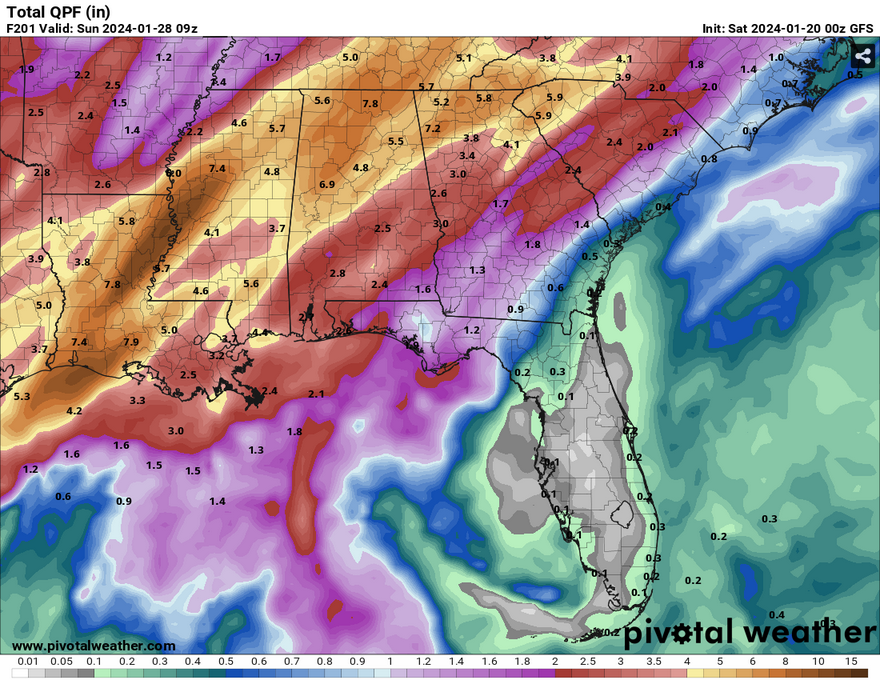
(Sidenote: the lack of rain in Florida makes it look like it’s in some sort of bubble)
Along with this warm front, a stationary front will begin to form below the Ohio River Valley but will mainly keep the rain pouring over us for several days until it starts to get a little bit of dynamic movement towards the end of the week. Depending on the setup of the front will mean who gets the heaviest amount of rain. The GFS has the largest amount of rain going to the southern portion of the Louisiana/Mississippi Delta and the southern portion of Louisiana, but we’ll have to look for model agreement to see where the front’s formation will likely bring the heaviest rain. Either way, we’ll look to get a minimum of 2 inches and even over 6 inches of rain depending on where the bands setup. Localized flooding will be possible and some river flooding may be possible.
The front will hang around into the weekend, however will leave Louisiana and Mississippi by the weekend leaving us drier and eventually cooler. So far, the SPC has not shown any specific severe weather chances for the week besides possible flooding, but depending on how dynamic one of these setups are, we may have a chance coming up.
Temperature range will likely hover around the 50s into the low 70s with little variation due to the moisture. By the weekend temperatures will start to dip to our normal winter-like temperatures in the 40s and 50s.
[wpcode id=”41179″]
Regional Day-to-Day Forecast
Today – Sunny, with a high in the low 40s. North wind around 10 mph, with gusts as high as 20 mph.
Tonight – Widespread frost after 2am. Otherwise, mostly clear, with a low around in the mid teens. Northeast wind 5 to 10 mph.
Sunday – Sunny, with a high in the mid 40s. East wind 5 to 10 mph.
Sunday Night – Mostly cloudy, with a low in the low 30s. East wind around 5 mph.
Monday – Mostly cloudy, with a high in the upper 50s. East southeast wind 5 to 15 mph, with gusts as high as 20 mph.
Monday Night – A 50 percent chance of showers. Mostly cloudy, with a low in the upper 40s. East southeast wind around 15 mph, with gusts as high as 25 mph. New precipitation amounts between a quarter and half of an inch possible.
Tuesday – Showers and possibly a thunderstorm. High in the mid 60s. Southeast wind around 15 mph, with gusts as high as 25 mph. Chance of precipitation is 80%.
Tuesday Night – Showers likely and possibly a thunderstorm. Mostly cloudy, with a low in the upper 50s. Southeast wind 10 to 15 mph, with gusts as high as 25 mph. Chance of precipitation is 70%.
Wednesday – Showers and possibly a thunderstorm. High in the low 70s. South southeast wind 10 to 15 mph, with gusts as high as 20 mph. Chance of precipitation is 90%.
Wednesday Night – Showers and possibly a thunderstorm. Low in the low 60s. Chance of precipitation is 90%.
Thursday – Showers and possibly a thunderstorm. High near 70. Chance of precipitation is 90%.
Thursday Night – Showers likely and possibly a thunderstorm. Mostly cloudy, with a low in the mid 50s. Chance of precipitation is 70%.
Friday – A 50 percent chance of showers. Mostly cloudy, with a high near 70.
[wpcode id=”41149″]


