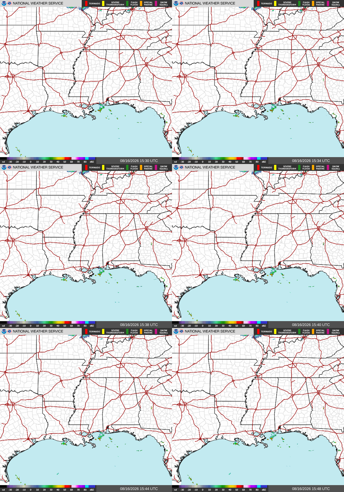
Good morning! Our radar is looking pretty empty right now, with no storms of any kind throughout our region.
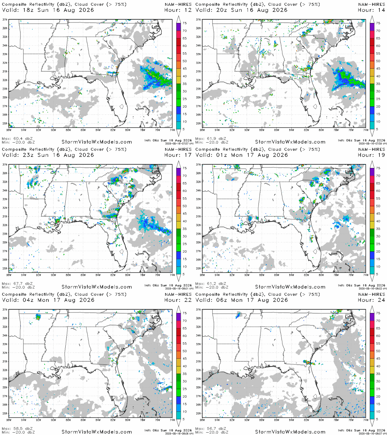
Throughout the day, the radar will fill up some, but not very much. We’re expecting a few sea breeze storms today in areas mostly closer to the coastline. The area between New Orleans and Mobile looks to be the place most likely to see storms tonight, so be prepared for that if you’re there. A few other storms are expected further north between Jackson and Birmingham this afternoon, but they are unlikely to last into the evening.
Rainfall totals will only amount to a tenth of an inch to a quarter of an inch, however places hit directly by a storm are likely to receive more.
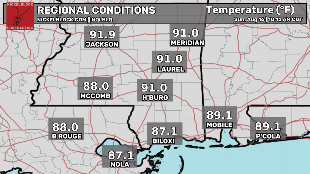
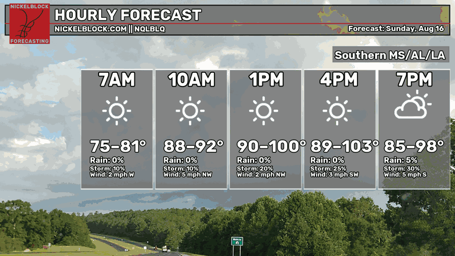
As of 10a CDT, outdoor conditions are already hot, with temperatures in the upper 80s and lower 90s throughout the area. These temperatures will continue to rise until the late afternoon, which is when afternoon highs will range from the low 90s to the lower 100s.
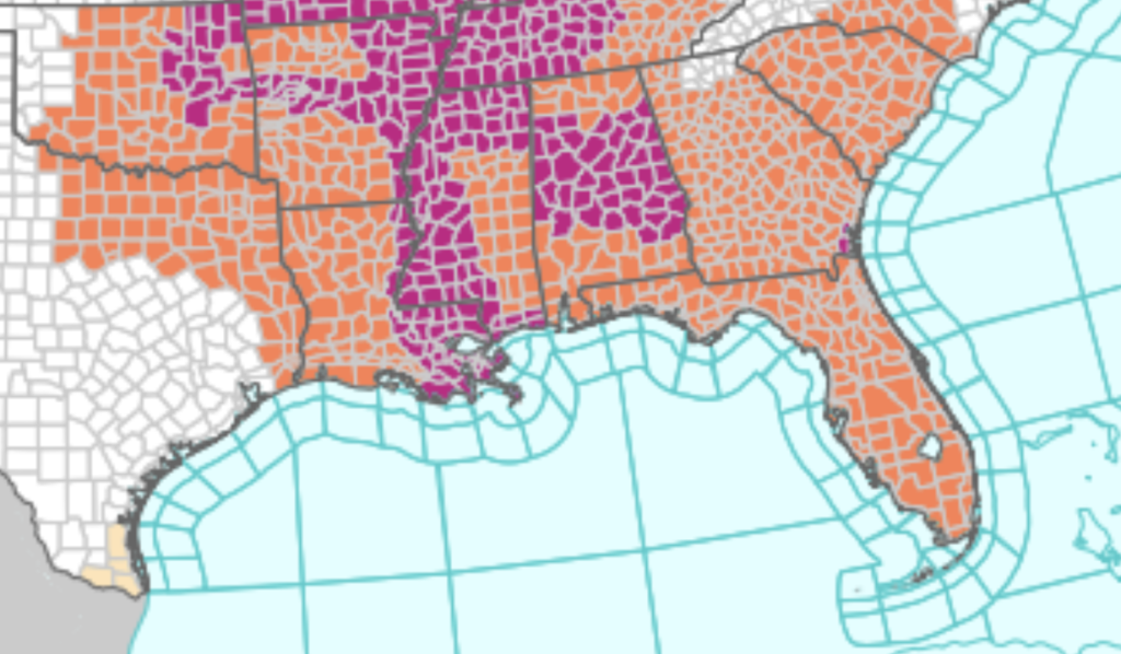
These temperatures have prompted the NWS to issue extreme heat warnings for a significant part of our region. The Mississippi coast, all of western Mississippi, southeastern Louisiana, and central Alabama are under extreme heat warnings. It’s important that you stay hydrated, wear sensible clothing, and avoid too much outdoor activity even if you’re not under an extreme heat warning.
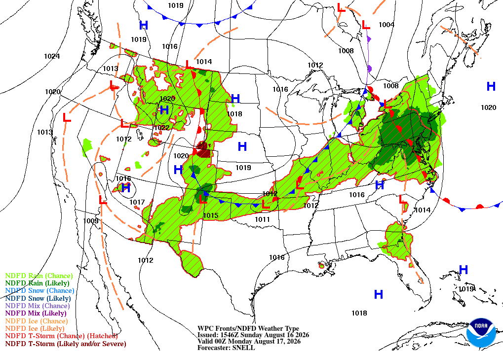
Tomorrow
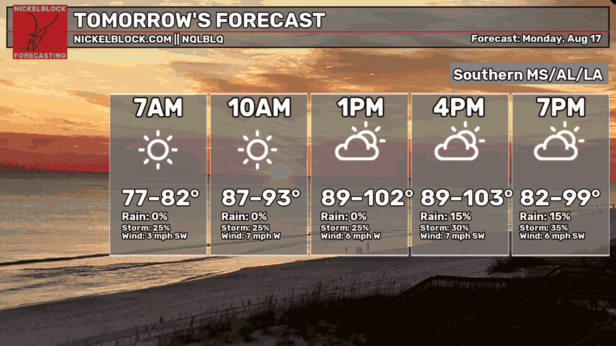
We’re expecting another dangerously hot day tomorrow, with afternoon highs forecasted to be in the lower 100s for many spots, possibly breaking a few record highs. In the morning, temperatures will only drop down into the upper 70s and lower 80s.
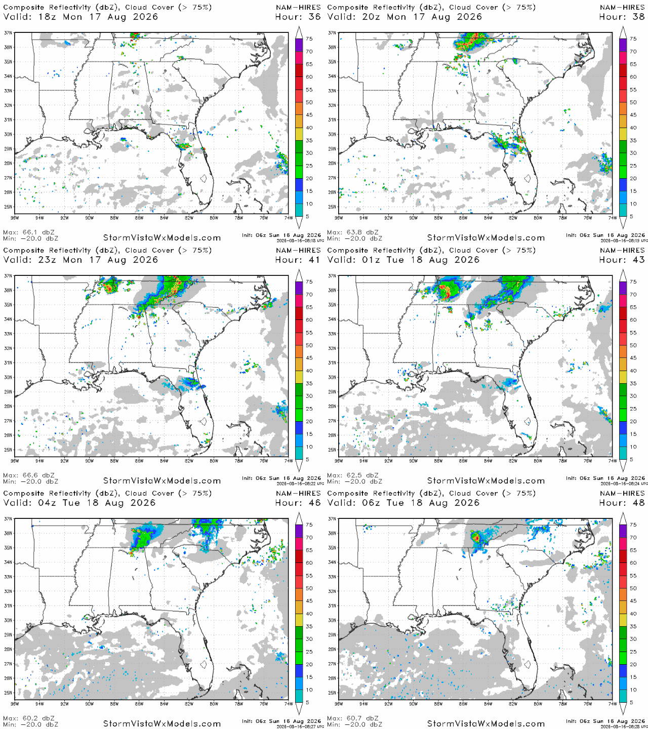
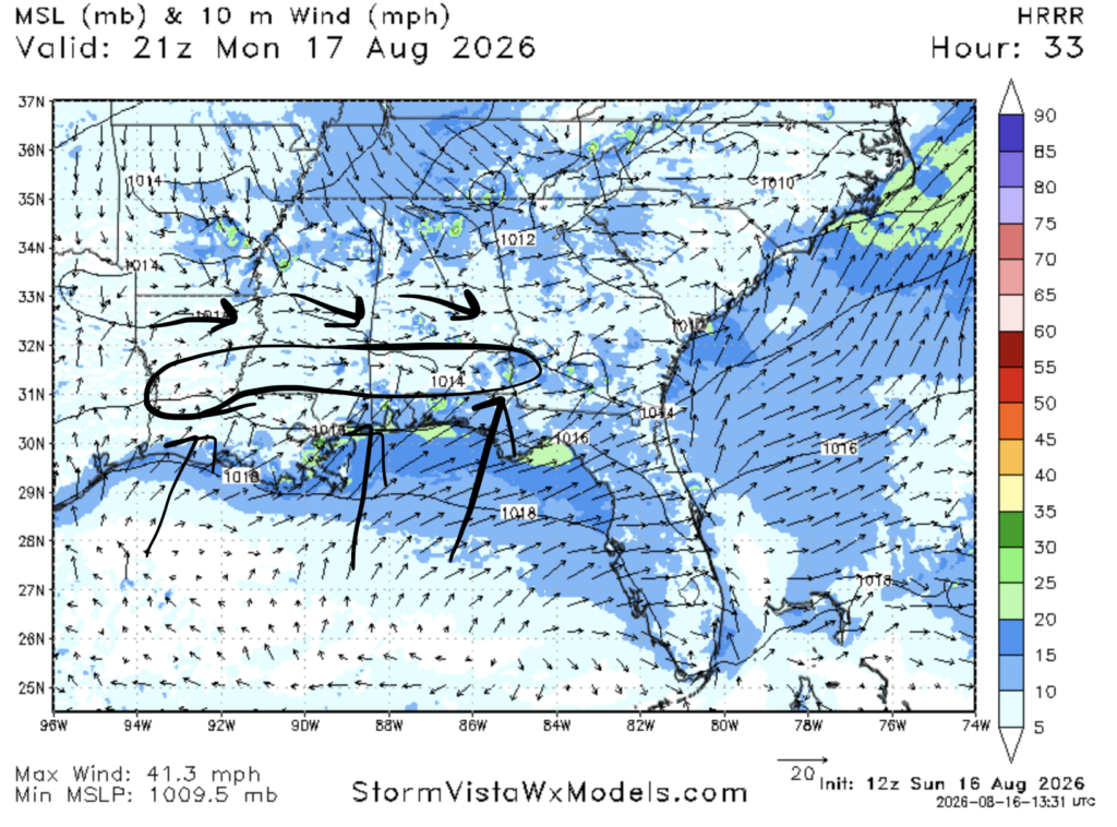
A few sea breeze storms are expected tomorrow where the sea breeze and wind circulated by the ridge will clash. The HRRR model is forecasting that area to be roughly 50 miles away from the coast, from Alexandria to Hattiesburg to Montgomery. Storm don’t look widespread, but they cannot be fully ruled out.
A few storms are also possible further north away from the center of the ridge, in northern Alabama and northern Georgia.
Airport Forecast
KHOU/KIAH (Houston) – Current: temperature is 83ºF, dew point is 76ºF, sky conditions are partly cloudy, winds are coming out of the northwest at 5 mph, and visibility is 10 miles. Tonight: skies will be sunny and hot today, but no storms are expected. No delays are expected.
KATL (Atlanta) – Current: temperature is 86ºF, dew point is 73ºF, sky conditions are a few clouds, winds are coming out of the northwest at 8 mph, and visibility is 10 miles. Tonight: skies will be sunny and hot today, and no storms are expected. No delays are expected.
KMSY (New Orleans) – Current: temperatures is 87ºF, dew point is 78ºF, sky conditions are mostly cloudy, winds are coming out of the northwest at 8 mph, and visibility is 10 miles. Tonight: skies will be mostly sunny and hot, and there is a slight chance of thunderstorms in the early-mid afternoon as well as in the late evening and early nighttime hours. Very minor delays are possible.
KBTR (Baton Rouge) – Current: temperature is 85ºF, dew point is 77ºF, sky conditions are fair, winds are coming out of the northwest at 9 mph, and visibility is 10 miles. Tonight: skies will be sunny and hot today, and few to no storms are expected tonight. No delays are expected.
KSHV (Shreveport) – Current: temperature is 84ºF, dew point is 73ºF, sky conditions are fair, winds are coming out of the southwest at 8 mph, and visibility is 10 miles. Tonight: skies will be sunny with a high likely in the low triple digits, but no storms are expected. No delays are expected.
KJAN (Jackson) – Current: temperature is 92ºF, dew point is 78ºF, sky conditions are fair, winds are coming out of the northwest at 9 mph, and visibility is 10 miles. Tonight: skies will be sunny and hot with a triple digit high possible, but no storms are expected. No delays are expected.
KBHM (Birmingham) – Current: temperature is 92ºF, dew point is 76ºF, sky conditions are a few clouds, winds are calm, visibility is 10 miles. Tonight: Skies will be sunny and hot and no storms are expected. No delays are expected tonight.
KMOB (Mobile) – Current: temperature is 89ºF, dew point is 77ºF, sky conditions are partly cloudy, winds are coming out of the northwest at 5 mph, and visibility is 10 miles. Tonight: skies will be sunny and hot, and a few sea breeze storms are possible beginning in the early afternoon until the evening. Very minor delays are expected tonight.
KTLH (Tallahassee) – Current: temperature is 89ºF, dew point is 73ºF, sky conditions are a few clouds, winds are coming out of every which direction at 3 mph, and visibility is 10 miles. Tonight: skies will be partly sunny and hot today with a few storms possible in the afternoon and evening. Very minor delays are possible.
Highway Forecast
I-10: A few sea breeze storms are expected in between New Orleans and Mobile tonight until around 8 pm. Everywhere else, storms are pretty unlikely. Overall, driving conditions will be excellent tonight.
I-20: A few storms this afternoon in between Jackson and Birmingham, but most storms should be gone by the evening. Storms are unlikely everywhere else. Overall, driving conditions will be excellent tonight.
I-49: Weather conditions will be sunny and hot today, but little to no storms are expected along this highway tonight. Overall, driving conditions will be excellent.
I-55: A few sea breeze storms are possible near the Mississippi/Louisiana border, but no storms are expected elsewhere. Overall, driving conditions will be excellent tonight.
I-59: A few storms are possible this afternoon between Tuscaloosa and Meridian as well as between Slidell and Hattiesburg this afternoon and evening. Overall, driving conditions will be very good tonight.
I-65: A few pop up storms are possible in the Birmingham area this afternoon, but they should not last into the evening. A few sea breeze storms are also possible near the coast in the Mobile area until around 8 tonight. No storms are expected elsewhere. Overall, driving conditions will be very good tonight.
I-75: A few minor pop up storms are possible in southern Georgia near the Florida border until around 8 tonight. Little to no storms are expected elsewhere tonight, so driving conditions should be excellent tonight.
3 Day City Forecast
Tallahassee, FL
Tomorrow: Skies will be mostly sunny throughout the day tomorrow with a high of 97ºF. A few scattered storms are possible between 2 and 8 pm. By night, skies will be partly cloudy and the temperatures should drop into the upper 70s.
Tuesday: Skies will be mostly sunny throughout the day on Tuesday with a high of 98ºF. There is a slight chance of storms beginning in the morning and lasting until the late afternoon. By night, skies will be partly cloudy and temperatures should drop into the mid-upper 70s.
Wednesday: Skies will be mostly sunny throughout the day with a high of 98ºF. There is a slight chance of storms and showers beginning in the afternoon and lasting until the late evening. By night, skies will be partly cloudy and temperatures should drop into the mid 70s.
Birmingham, AL
Tomorrow: Skies will be sunny throughout the day tomorrow with a high of 98ºF. Southeast moving storms are possible beginning in the early afternoon and lasting until around 7-8 pm. By night, skies will be mostly clear and temperatures should drop into the mid 70s.
Tuesday: Skies will be sunny throughout the day on Tuesday with a high of 95ºF. Storms are unlikely on Tuesday. By night, skies will remain mostly clear and temperatures should drop into the mid 70s.
Wednesday: Skies will be sunny throughout the day on Wednesday with a high of 97ºF. Some storms are possible in the evening lasting until after midnight. By night, skies will be partly cloudy and temperatures should drop into the mid 70s.
Mobile, AL
Tomorrow: Skies will be mostly sunny throughout the day tomorrow with a high of 98ºF. A few sea breeze storms are possible in the afternoon and early evening. By night, skies will be partly cloudy and temperatures should drop into the mid-upper 70s.
Tuesday: Skies will be mostly sunny throughout the day on Tuesday with a high of 97ºF. A few storms are possible beginning in the afternoon/evening and lasting until the night. By night, skies will be partly cloudy and temperatures should drop into the mid 70s.
Wednesday: Skies will be mostly sunny throughout the day on Wednesday with a high of 96ºF. Some storms are possible in the evening lasting until past midnight. By night, skies will be partly cloudy and temperatures should drop into the mid 70s.
Atlanta, GA
Tomorrow: Skies will be sunny throughout the day tomorrow with a high of 98ºF. A few storms are possible between 2 and 8. By night, skies will be mostly clear and temperatures should drop into the mid-upper 70s.
Tuesday: Skies will be sunny throughout the day on Tuesday with a high of 95ºF. No storms are expected on Tuesday. By night, skies will be mostly clear and temperatures should drop into the mid 70s.
Wednesday: Skies will be sunny throughout the day on Wednesday with a high of 97ºF. No storms are expected on Wednesday. By night, skies will be mostly clear and temperatures should drop into the mid-upper 70s.
Jackson, MS
Tomorrow: Skies will be sunny and very hot with a high of 100ºF tomorrow. No storms are expected tomorrow. By night, skies will remain mostly clear and temperatures should drop into the mid-upper 70s.
Tuesday: Skies will be sunny and very hot once again with a high of 100ºF on Tuesday. A few showers and storms are possible in the nighttime hours until after midnight. By night, skies will be partly cloudy and temperatures should drop into the mid 70s.
Wednesday: Skies will be sunny throughout the day on Wednesday with a high of 99ºF. A few storms are possible in the evening lasting into the night. By night, skies will be partly cloudy and temperatures should drop into the mid 70s.
New Orleans, LA
Tomorrow: Skies will be sunny throughout the day tomorrow with a high of 97ºF. No storms are expected tomorrow. By night, skies will be partly cloudy and the temperatures should drop into the upper 70s-lower 80s.
Tuesday: Skies will be mostly sunny throughout the day on Tuesday with a high of 96ºF. No storms are expected. By night, skies will be partly cloudy and temperatures should drop into the upper 70s-low 80s.
Wednesday: Skies will be mostly sunny throughout the day on Wednesday with a high of 95ºF. A few storms are possible in the afternoon/evening and lasting into the night. By night, skies will be partly cloudy and temperatures should drop into the upper 70s-low 80s.
Baton Rouge, LA
Tomorrow: Skies will be sunny throughout the day tomorrow with a high of 98ºF. No storms are expected tomorrow. By night, skies will be mostly clear and temperatures should drop into the upper 70s.
Tuesday: Skies will be mostly sunny throughout the day on Tuesday with a high of 98ºF. No storms are expected on Tuesday. By night, skies will be partly cloudy and temperatures should drop into the upper 70s-low 80s.
Wednesday: Skies will be sunny throughout the day with a high of 97ºF. No storms are expected on Wednesday. By night, skies will be partly cloudy and temperatures should drop into the mid 70s.
Shreveport, LA
Tomorrow: Skies will be sunny throughout the day tomorrow with an extremely hot high of 103ºF. No storms are expected tomorrow and skies should remain clear all day. By night, skies will remain clear and temperatures should drop into the upper 70s-low 80s.
Tuesday: Skies will be sunny and excessively hot with a high of 102ºF on Tuesday. No storms are expected. By night, skies will be mostly clear and temperatures should drop into the low 80s.
Wednesday: Skies will be sunny and very hot with a high of 101ºF on Wednesday. No storms are expected. By night, skies will be mostly clear and temperatures should drop into the upper 70s-low 80s.
Houston, TX
Tomorrow: Skies will be sunny throughout the day tomorrow with a high of 98ºF. Cloud cover should increase as the afternoon goes on. No storms are expected. By night, skies will remain mostly clear and temperatures should drop into the upper 70s-low 80s.
Tuesday: Skies will be sunny throughout the day with a high of 98ºF. No storms are expected on Tuesday. By night, skies will be mostly clear and temperatures should drop into the upper 70s-low 80s.
Wednesday: Skies will be sunny with a very hot high of 100ºF on Wednesday. No storms are expected. By night, skies will be mostly clear and temperatures should drop into the upper 70s.


