Good Tuesday everyone! I hope you all are finding ways to stay dry. Prolonged rain will continue to be an issue for most of the week. A stalled frontal boundary oriented west to east across the Southeast will be the focus for shower and thunderstorm activity again.
A surface to mid-level low pressure center is over the Texarkana region and will persist for the next couple of days. Interacting with the boundary, this low will bring plenty of rain through SW MS beginning in the morning by supporting low-level convergence and lift for storms to initiate.
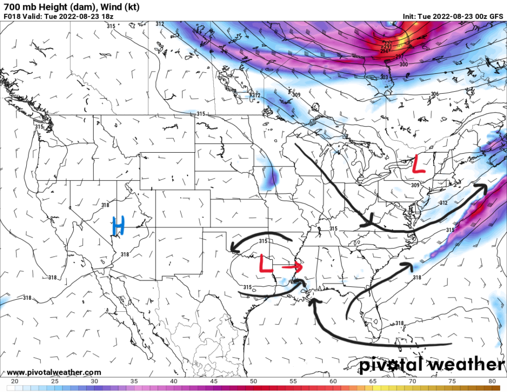
With the Bermuda high stretching into Florida, there will continue to be southerly into the Gulf Coast from the Gulf of Mexico. This will keep moisture levels elevated in the atmosphere south of the frontal boundary. Widespread showers and thunderstorms are expected. Moving in before sunrise and lasting throughout the day. Coverage will decrease a bit heading into Tuesday night, but will increase once again on Wednesday.
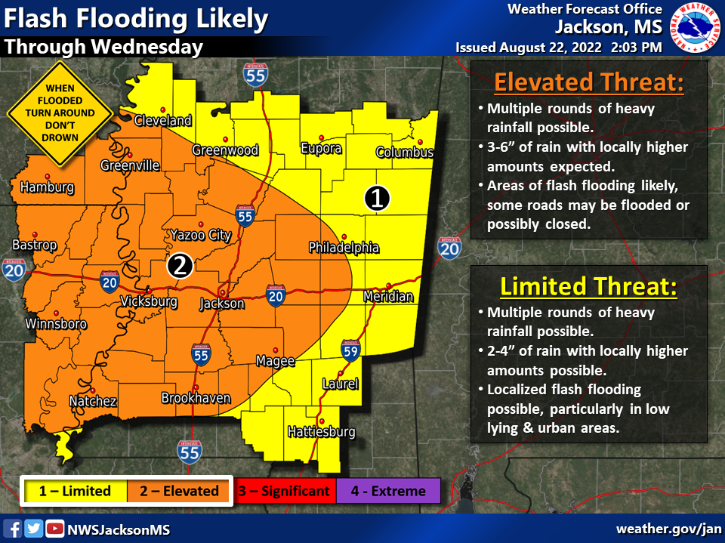
With precipitable water values ranging between 2″ and 2.4″ across the area, flooding will be a concern. Heavy rainfall from training storms could bring rainfall totals up to 4″ with locally higher amounts up to 7″. Flash flooding will also be an issue with the ground already being very saturated and river levels heightened. There will be a flood watch through Tuesday and possibly through the night as well.
When driving somewhere like work, give yourself extra time incase you encounter a flooded roadway. Take detours if you cannot see the bottom of the road through the water. Remember to turn around and don’t drown. Do not risk stalling your car out in flood waters.
With increased cloud coverage and rainfall, high temperatures will struggle to reach the upper 70s. Some places may reach into the low 80s. This will continue for the short term before rain chances decrease and become more diurnally driven by the weekend. Thus, temperatures will begin to climb back into the mid-to-upper 80s.
Day-to-Day Forecast
Tuesday
Cloudy with a 90-percent chance of widespread showers and storms throughout the day. Highs will be in the upper 70s. Lows in the low 70s.
Wednesday
Cloudy with a 90-percent chance of widespread showers and storms throughout the day. Highs will be in the upper 70s and low 80s. Lows in the low 70s.
Thursday
Cloudy with a 80-percent chance of widespread showers and storms throughout the day. Highs will be in the low 80s. Lows in the low 70s.
Friday
Partly cloudy with a 50-percent chance of precipitation. Highs in the mid 80s. Lows in the low 70s.
Saturday
Mostly sunny with a 50-percent chance of precipitation. Highs in the mid 80s. Lows in the low 70s.
Sunday
Mostly sunny with a 60-percent chance of precipitation. Highs in the mid-to-upper 80s. Lows in the low 70s.
Monday
Mostly sunny with a 60-percent chance of precipitation. Highs in the mid-to-upper 80s. Lows in the low 70s.


