Mother Nature decided to crank up the heat heading into our first full week of June. After some heavy storms moved into Northern MS/AL yesterday, creating flash flooding in some cities, the outlook shows some dry and hot days up ahead.

Today
For our Monday afternoon across the South, expect hot and humid weather as high-pressure systems over Arkansas and AL/GA create quiet conditions. Isolated storms are possible across the region, as high temperatures often fuel small storms in the afternoons. No organized systems or major storms are expected in our area.
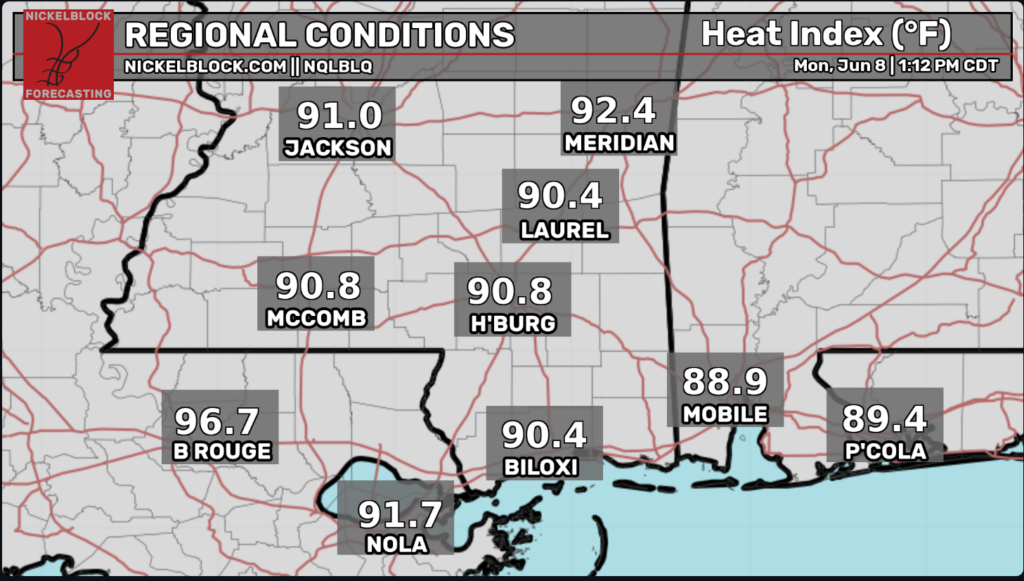
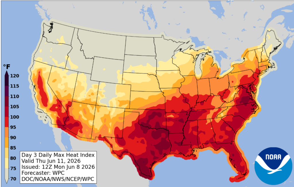
Looking at our regional heat index graphic below, we are seeing high “feel like” temperatures in the neighborhood. The heat index is what the temperature feels like to the human body, taking both temperature and humidity into consideration. Higher humidity makes it harder for sweat to evaporate, reducing the body’s ability to cool itself. That’s why even though it is 88 degrees in Baton Rouge today, it feels like 96.7 degrees since it is so humid in the area.
Tomorrow
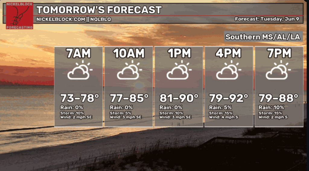
Tuesday is shaping up to look a lot like today across Southern MS/AL/LA. High humidity and temperatures will drive the heat index up to the mid to high 90s for the “real feel” heading into the afternoon. A bit of cloud coverage with light winds will hopefully soothe some of that stickiness from the higher temperatures tomorrow.
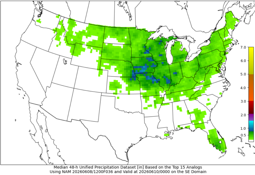
The 48-hr unified precipitation forecast courtesy of the Cooperative Institute for Precipitation Systems (CIPS) shows a dry next couple of days across our area, with a small chance for scattered rainstorms which will not exceed half an inch of rainfall.

The Next Few Days
Going into the rest of our week, the heat index will continue to be high over our area. While air temperatures will top out in the high 80s/lower 90s, high humidity will push heat index values into the upper 90s during the afternoon hours. Make sure you are drinking lots of water, especially when participating in summertime outdoor activities.
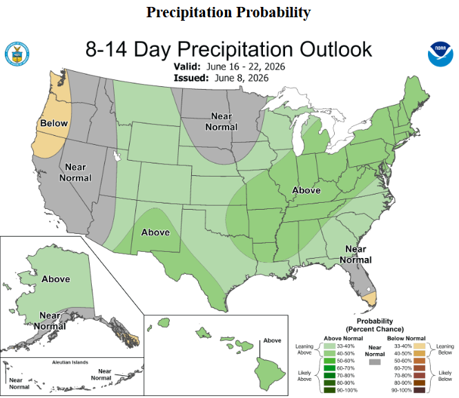
Taking a look at our precipitation forecast for the next few days, we are seeing a surprisingly dry week according to Pivotal Weather. Rounds of showers will be popping up in the afternoons more likely than not, but no organized storm systems look to be forming, giving us a warm and quiet rest of the week.
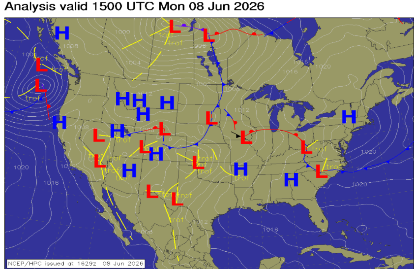
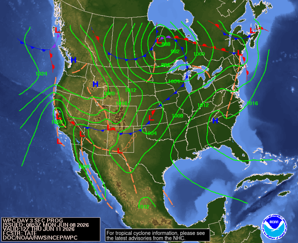
The surface analysis chart below from the Weather Prediction Center shows a high-pressure system over the Southern Appalachian Mountains which will settle down into the gulf towards the end of the week. This will keep our weather relatively quiet as high-pressure systems are associated with sinking air, suppressing widespread thunderstorm development.
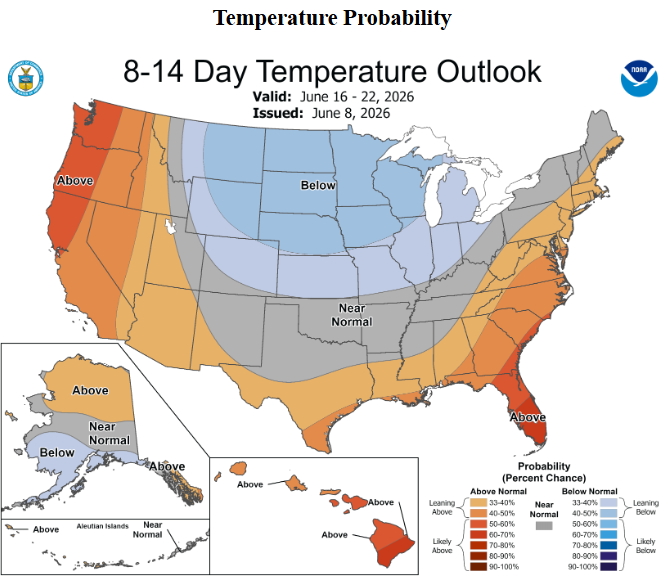
Extended Forecast
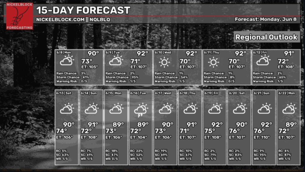
Looking ahead into the weekend and beyond, temperatures seem to be slightly above average after the heat of this week is over, with some rain coming our way as we get closer to the summer solstice on the 21st.
What does the summer solstice mean for us?
The summer solstice marks the point of maximum daylight for the Northern Hemisphere, meaning that the Sun is at its highest angle in the sky and we’re receiving the strongest sustained solar energy of the year. Now, this doesn’t mean that it is the hottest day of the year, but it does mean that summer is in full swing. This will eventually bring higher temperatures to fuel stronger afternoon storms and potential tropical threats.
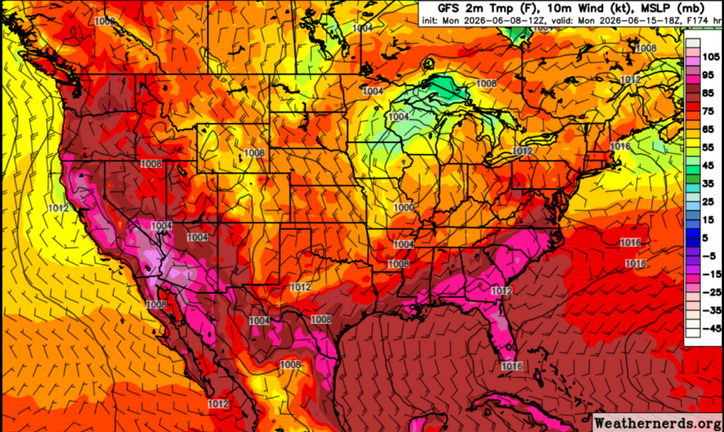
Looking above at some GFS data showing 2m temps, 10m wind, and the Mean Sea Level Pressure (MSLP), we see the potential for storms and precipitation early next week. The average MSLP is 1013.25mb and anything above that value calls for clear, settled weather, while anything below often brings storms and precipitation. As we move into the week, our MSLP drops below the 1013.25mb mark, meaning rain is most likely on the way.
This is evident in the NickelBlock 15-day extended forecast below, where we see higher storm chances moving into next week.