I want to start with a brief note for the folks in northwestern Florida and southwestern Alabama. I know we often include you guys in our general forecasts, day-to-day. But for high impact weather like this I would really, really encourage you guys to check out Spinks Megginson. While I can give you guys a general idea of what to expect, Spinks can give you the really detailed, nitty-gritty stuff plus he provides live coverage of things like tornado warnings or flash flood emergencies.
While our friends across the Florida panhandle and Lower Alabama will be dealing with the biggest impacts from Hurricane Isaias, the rest of us in Louisiana and Mississippi will be sitting on the outside looking in sending well wishes and prayers that everyone makes it through okay.
Hurricane Isaias is currently a Major Hurricane. It has sustained wind recorded by a dropsonde of greater than 120mph.
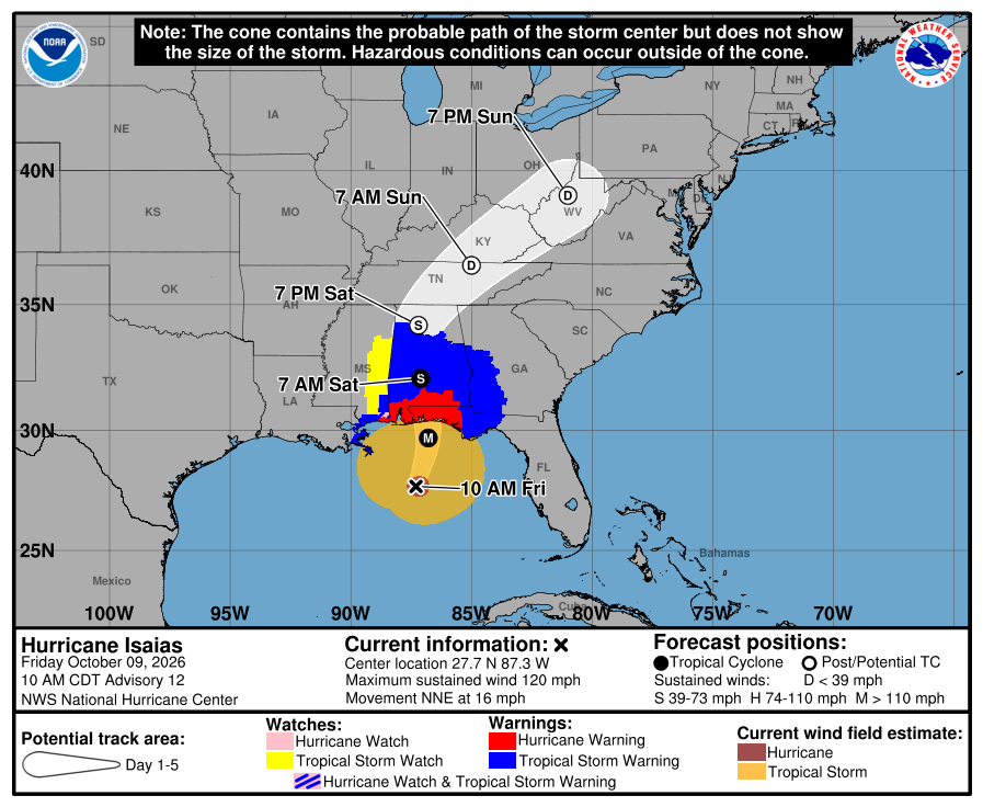
Landfall is expected to be tonight between 6p and 9p near the Alabama-Florida border. The main impacts to Louisiana and Mississippi will be between 11p and 5am tonight and into tomorrow morning with brief heavy rains and gusty wind. Localized flooding will be possible where rainbands get “stuck” and rain over the same areas for a longer period of time.
….A BREAKDOWN OF IMPACTS FOR LOUISIANA & MISSISSIPPI….
— MANY SPOTS: HEAVY RAIN AT TIMES, SUSTAINED WIND PEAKING AROUND 35MPH, PEAK GUSTS TO 50MPH
— SOME PEOPLE: HEAY RAIN AT TIEMS, SUSTAINED WIND PEAKING AROUND 40MPH, PEAK GUSTS TO 60MPH
— A FEW LOCATIONS (MAINLY SOUTHEAST AREAS): MULTIPLE ROUNDS OF HEAVY RAIN, SUSTAINED WIND PEAKING AROUND 50MPH, PEAK GUSTS UP TO 75MPH

RIGHT NOW & COMING UP TONIGHT
The core of the strongest wind, based on dropsondes and satellite estimates, is on the east side of the storm.
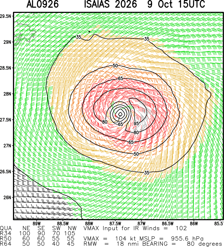
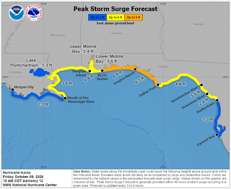
There is some good indication within teh model guidance that this core of strongest wind will weaken a bit as the storm moves closer to shore, but this will still be a dangerous storm with a very potent storm surge of 6ft to 9ft along the Florida panhandle coastline.
Looking back up at the first image from the National Hurricane Center, the Tropical Storm-force wind does look to have a pretty expansive envelope. The NHC estimates that wind speeds greater than 40mph spread out nearly 90 miles from the center of the storm in some spots.
That said, as it gets closer to shore a few things are going to change….
- Friction will slow wind down: The wind will physically me moving through tres, buildings, cars, people, and “stuff” on land that will help to slow it down. so the expanse of wind will be a bit more limited than it would be over open ocean
- Rising pressure internally will expand the general wind field: The interesting sciency part of the equation is that as a storm “weakens” and the central pressure rises a bit, it tightens the pressure gradient farther out from the center, increasing the “general” wind speed across the rest of the storm. And this tends to impact the points farther from the center more than the points closest. So, despite friction slowing the wind down… as it “weakens”, the slow down in wind may not be as pronounced, given this physical change taking place.
- Wind will be bursty on the west side: I tend to think the background wind speed for most folks in Louisiana and Mississippi (not counting Greene, George and Jackson counties where it will be about 5-15mph higher) will be between about 15mph and 30mph with gusts up to 50mph possible. But those gusts and higher sustained wind speeds will be underneath any rain showers or rainbands that move across the area and we are able to “mix down” the wind from aloft. So if you stay dry all night and all day Saturday, you may not see wind higher than 25mph with a few gusts to 35mph.
Once we get toward midnight tonight, the HWRF model shows the system may be a bit one-sided with most of the rain on the northern side and the eastern side, with a large dry slot on the southern and western side.
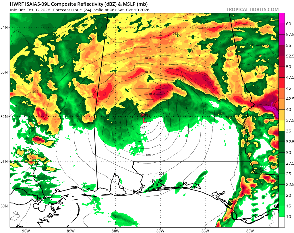
This is why overnight tonight, I think is the best chance to see the brief bursts of heavy rain and gusty wind for Louisiana and Mississippi. When we have times where rainbands are flung around to the west side of the system, we get an uptick in wind and rain.
The strongest wind will be confined to the tightest area closest to the center. Even at this point as the pressure gradient is relaxing. Looking at he peak Wind Gusts below, you can see how the computer models think the winds will really slow down as this moves ashore between 9p on the left and midnight ont he right.
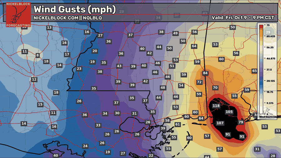
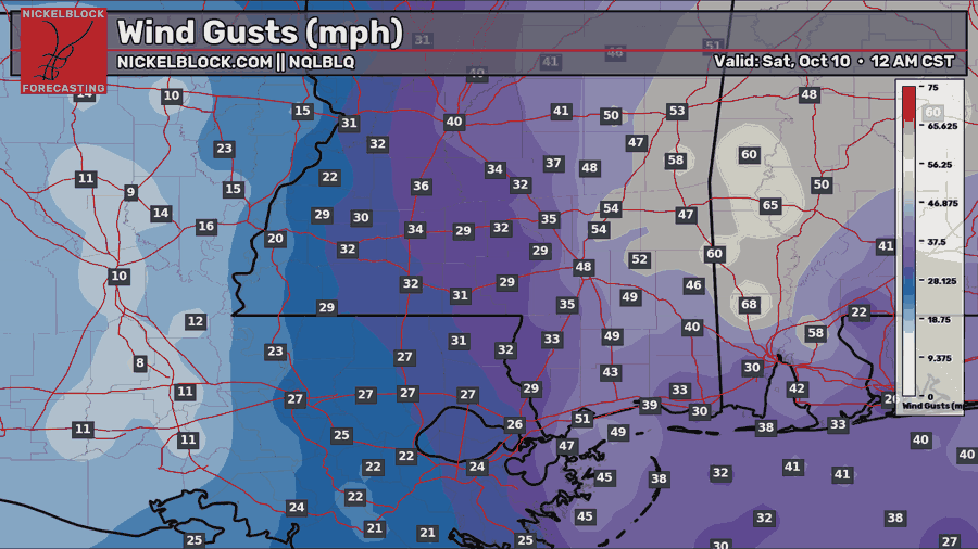
The sustained wind speeds on the models are probably a little too low, but that can give you a good idea about what the wind will be doing, generally, across the evening tonight.
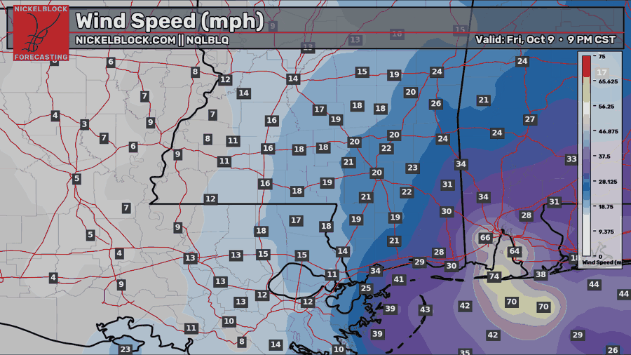
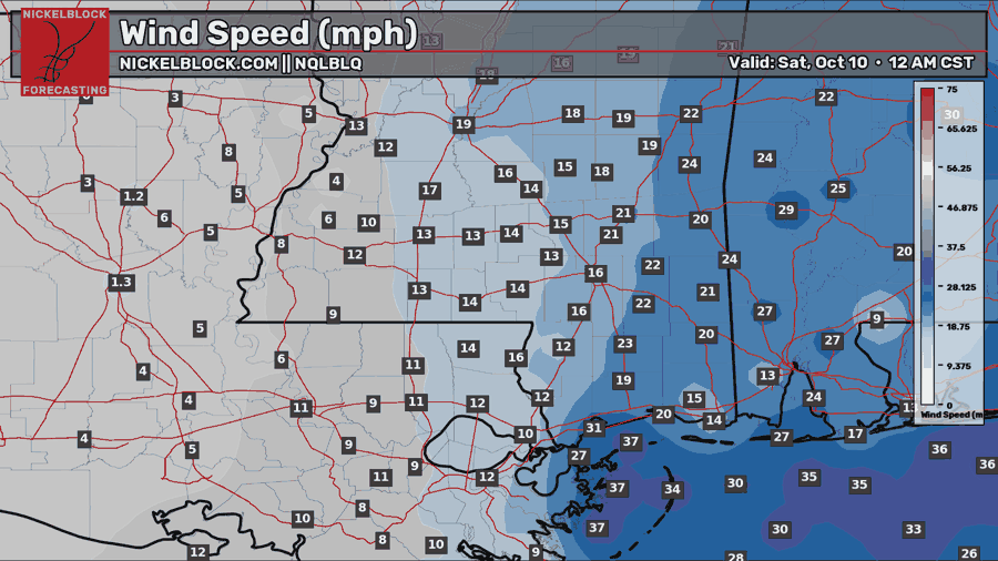
Again, probably under-representing the true wind speeds by 5-10mph in many spots, but you can see how much wind most of Louisiana and Mississippi will actually be dealing with here: Not much.
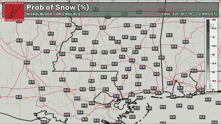
Oh, and just in case anyone was curious: No snow from this hurricane.
Rainfall totals across the area will depend on where rainbands set up, but according to the NHC and WPC, aren’t particularly high across our area:
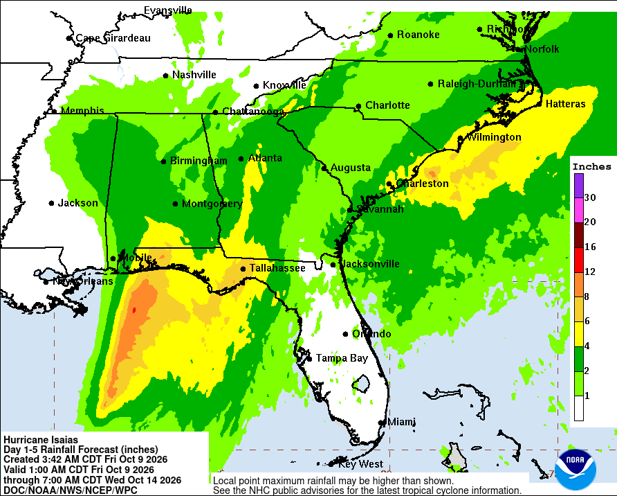
Some folks will get more than the 1″ to 3″ of rain shown, but those will be highly localized spots.
AFTER TONIGHT
Tomorrow the wind should relax a bit through the day, but I think we will hold on to a breeze through the afternoon as vertical mixing allows some of the higher wind aloft to mix down.
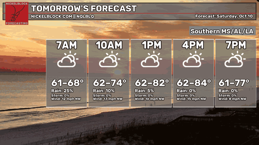
Temperatures will depend on your location. I find it unlikely someone would still be at 62 degrees in the afternoon. I expect low 70s to low 80s and high temps.
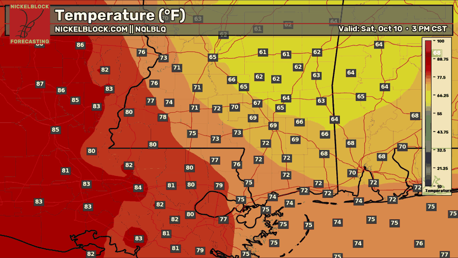
That said, the model guidance seems to think we will see an extratropical transition of ISaias quickly and we will mix in some cooler temps. Not sure I buy that yet.

15-DAY OUTLOOK
Once we get beyond Saturday, this thing should start to lift out of here and we have a bit of ridging build into the area that should pop temps back into the 90s. You guys know the drill! Hurricane nearby? After it leaves, it gets hot!
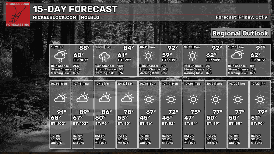
But a cold front is on the horizon! It looks like late next week / next weekend we have a “blue Norther” trying to sneak into the South. Not sure I buy that, either, yet. But it has been showing up the model guidance for a few days now. That should knock temps back from the 90s to the 80s and into the 60s and 70s.
Again, a cool down I’ll agree with. A stretch of 60s and 70s is still TBD.


