No major weather-related concerns through the rest of the week nor through the weekend. Mother Nature is going to cooperate with any outdoor plans and make your day-to-day rather pleasant.
Highs during the next few days will be in the 70s and 80s.
Then things start to cloud up on Sunday night and through most of the next week with chances for rain and storms here and there. In fact, it looks like the clouds will show up just in time for the Eclipse. A total bummer for those that didn’t get to take advantage of the last one.
So far the forecast for Monday is mostly cloudy skies with a 20 percent chance for showers. Not great conditions for viewing the sun.
There will be a shot for a few storms mixed in on Monday and Tuesday, but the real risk for more impactful storms arrives on Wednesday and into Thursday.
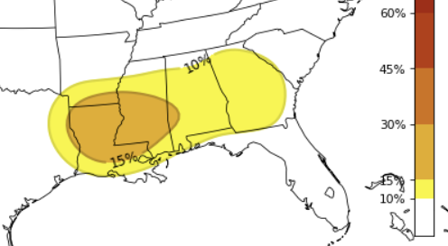
The CIPS Analogs have an orange 15% risk over the top of us for midweek next week. And, unlike last week, I think this has some legs. The system that is set to kick through looks to have some potency, and the question will be how far south does the potent weather develop.
Once the storms kick through, we set the stage for what looks like another nice weekend.
REGIONAL DAY TO DAY FORECAST
Today: Sunny. Highs in the lower 70s. West winds 10 to 15 mph with gusts up to 25 mph.
Tonight: Clear. Lows in the lower 40s. Northwest winds 5 to 10 mph.
Friday: Sunny. Highs in the upper 70s. Northwest winds around 5 mph, increasing to around 10 mph with gusts up to 20 mph in the afternoon.
Friday Night: Mostly clear. Lows in the mid 40s. North winds around 5 mph.
Saturday: Mostly sunny. Highs in the upper 70s. Northeast winds around 5 mph, becoming southeast in the afternoon.
Saturday Night: Partly cloudy. Lows in the lower 50s.
Sunday: Mostly sunny. Highs in the upper 70s.
Sunday Night: Partly cloudy in the evening, then becoming mostly cloudy. Lows around 60.
Monday (Eclipse Day): Mostly cloudy with a slight chance of thunderstorms. A chance of showers, mainly in the morning. Highs in the upper 70s. Chance of rain 30 percent.
Monday Night: Mostly cloudy. A slight chance of showers after midnight. Lows in the mid 60s. Chance of rain 20 percent.
Tuesday: Mostly cloudy with a chance of showers with a slight chance of thunderstorms. Highs around 80. Chance of rain 40 percent.
Tuesday Night: Mostly cloudy with a slight chance of thunderstorms. A slight chance of showers in the evening, then a chance of showers after midnight. Lows in the mid 60s. Chance of rain 40 percent.
Wednesday: Mostly cloudy with a chance of showers. A slight chance of thunderstorms in the morning, then a chance of thunderstorms in the afternoon. Locally heavy rainfall possible. Highs in the upper 70s. Chance of rain 40 percent.


