Today will be the last fully dry day until just about this time next week. The weather pattern is shifting from higher pressure being in control, so a more active pattern with a stalled front and little systems passing by bringing us a few shots for rain each day, as well as the potential for a few strong or severe storms here and there.
Today, it will be chilly still, highs will top out around 60F.
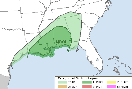
Tomorrow, a surface low developing over the Red River Valley into Oklahoma will bring warm advection rain showers across parts of the area — but not until the afternoon and evening. Storms will be possible, too, as we head into the overnight hours. There will be a pretty potent jet streak aloft which may give a boost to the limited instability in place, but even so, it may not be enough to produce widespread severe weather. But one or two storms that can get rooted may strengthen past severe limits.
The timeline for the highest potential for severe weather will be between 10p Thursday night and 10a Friday morning.
As the cold front moves in on Friday, it will give us a brief break from the rain in the afternoon. Then, Friday night the front may stall a bit and lift back northward slightly. That stalled front will be with us through the weekend. That front, mixed with the upper-level flow running parallel to said front, will lead to additional rainfall — without the threat for severe weather.
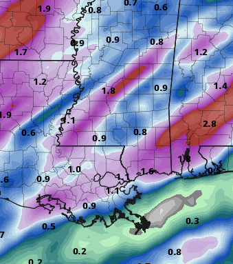
Yesterday I mentioned that I was skeptical of some of the rainfall totals shown in the model guidance. I was right to give the numbers a bit of a ‘side-eye’ as the data today cut those estimates (nearly) in half. Rain total estimates look to be between 1-3″ across the area between Friday night and Monday morning.
[wpcode id=”41149″]
REGIONAL DAY-TO-DAY FORECAST
Wednesday: Sunny. Highs around 60. East winds around 5 mph.
Wednesday Night: Mostly cloudy. Lows in the upper 30s. East winds around 5 mph.
Thursday: Partly sunny. A slight chance of showers in the afternoon. Highs in the mid 60s. Southeast winds 10 to 15 mph. Chance of rain 20 percent.
Thursday Night: Mostly cloudy with a chance for rain and storms overnight. Lows in the mid 60s. Southeast winds 15 to 20 mph with gusts up to 30 mph. Chance of rain 80 percent.
Friday: Cloudy with rain and storms in the morning. Drier in the afternoon. Highs in the upper 70s. Chance of rain 70 percent.
Friday Night: Cloudy with a slight chance of thunderstorms. A chance of showers in the evening, then showers likely after midnight. Lows in the lower 60s. Chance of rain 60 percent.
Saturday: Showers likely with a slight chance of thunderstorms. Highs in the lower 70s. Chance of rain 60 percent.
Saturday Night: Cloudy with a slight chance of thunderstorms. A chance of showers in the evening, then showers likely after midnight. Lows around 60. Chance of rain 40 percent.
Sunday: Cloudy with a chance of showers with a slight chance of thunderstorms. Highs in the lower 70s. Chance of rain 60 percent.
Sunday Night: A slight chance of thunderstorms in the evening. Mostly cloudy with a chance of showers. Lows in the lower 50s. Chance of rain 40 percent.
Monday: Mostly cloudy with a 20 percent chance of showers. Highs in the upper 60s.


