Rain will be moving into the area as we move through this afternoon and evening. And then may be with us overnight and through part of the day on Friday and into Saturday, too. And then also on Sunday. And then even Monday, as well.
Here is a breakdown of the next 48 hours from the HRRR model:
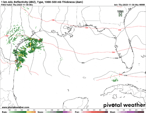
Notice that a lot of the heaviest rain – and the highest likelihood for severe weather – according to this model remains near the coast and out into the Gulf. This may be a situation where we are saved by “The Blob” again.
The Blob is when a bluster of storms fires up off the coast and out into the waters of the Gulf. It cuts off the flow of rich Gulf air into the area. And then it limits the surface-based severe weather threat (tornadoes).
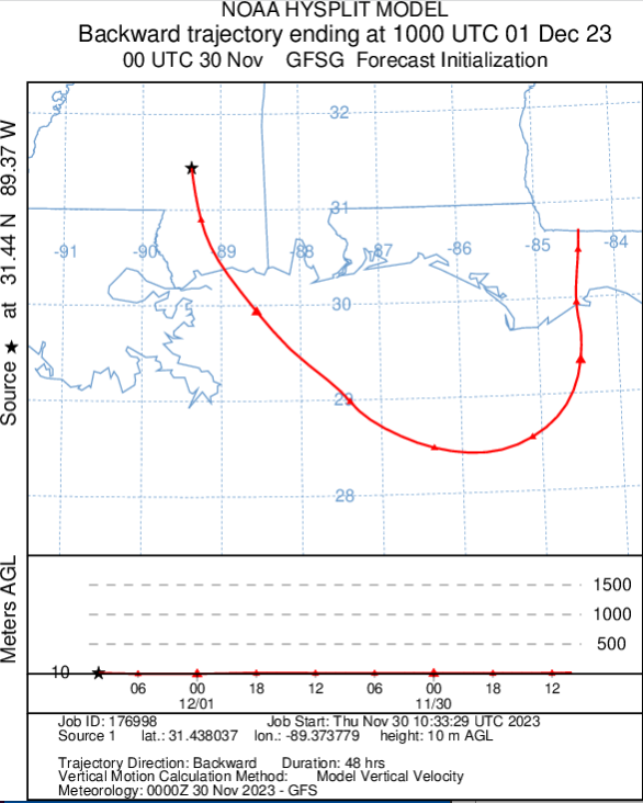
We also have some evidence that we may not be pulling the richest Gulf air, too. Looking at the HYSPLIT model from NOAA, it looks like we are only going to receive some recirculated Florida Panhandle air as the storms move through. That isn’t exactly “juicy” stuff for big storms to gobble up.
Instead, it is looking more likely that we deal with mostly rain and thunder, with a few stronger storms possible nearer to the coast. That doesn’t mean you can ignore the SPC’s Marginal Risk for severe weather, but rather that the Marginal Risk is doing a good job portraying the risk.
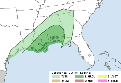
The risk is pretty low, but we can’t rule out the opportunity for a storm here and there to be strong or severe.
[wpcode id=”41149″]
REGIONAL DAY-TO-DAY FORECAST
Today: Partly sunny this morning, then becoming mostly cloudy. Highs in the mid 60s. East winds 5 to 10 mph.
Tonight: Showers likely in the evening with storms possible overnight. Lows in the mid 60s. Southeast winds 5 to 10 mph. Chance of rain 70 percent.
Friday: Mostly cloudy with a chance of thunderstorms. Highs in the upper 70s. South winds 10 to 15 mph. Chance of rain 40 percent.
Friday Night: Cloudy storms possible. Near steady temperature in the mid 60s. South winds 10 to 15 mph. Chance of rain 40 percent.
Saturday: A chance of thunderstorms. Showers. Highs in the mid 70s. South winds 10 to 15 mph. Chance of rain 60 percent.
Saturday Night: Cloudy with a rain and storms possible. Lows in the lower 60s. Chance of rain 40 percent.
Sunday: A slight chance of thunderstorms in the morning. Cloudy with a chance of showers. Highs in the lower 70s. Chance of rain 40 percent.
Sunday Night: Mostly cloudy with a 30 percent chance of showers. Cooler with lows in the lower 50s.
Monday: Mostly cloudy in the morning, then becoming partly sunny. A 20 percent chance of showers. Highs in the mid 60s.
Monday Night: Mostly cloudy. Lows in the mid 40s.
Tuesday: Partly sunny. Highs in the mid 60s.
Tuesday Night: Mostly cloudy in the evening, then becoming partly cloudy. Lows in the mid 40s.
Wednesday: Mostly sunny. Highs in the lower 60s.


Nick I followed you when you were at WDAM and am still following your weather forecast. Thank you so much for all you still do to keep us safe. You are an exceptional person.