Just a quick forecast this morning!
The dry weather continues today, tonight through Wednesday night, with the coldest night expected tonight due to a surface ridge over the Deep South. Radiational cooling may lead to a frost/freeze across parts of the area, with some reaching the 20s.
Wednesday afternoon will be milder, and Wednesday night less cold as southerly flow returns.
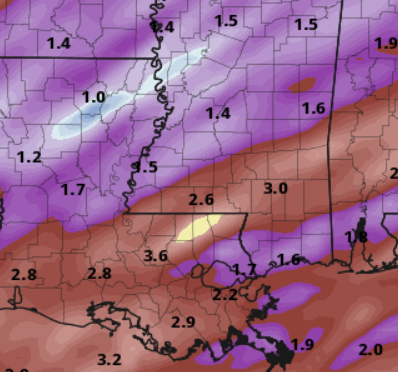
From Thursday to Monday, an active weather pattern is anticipated, bringing much-needed rain. A mid-level shortwave trough on Thursday will lead to showers to the area. Convection may develop to the west, possibly leading to strong to severe storms. After a break on Friday, the surface front will stall, causing additional rainfall over the weekend into early next week. Computer weather model estimates show 2-4″ in the Pine Belt and 1-2″ elsewhere. Short-term, brief flash flooding may be possible underneatht he strongest storms with the heaviest rain, but widespread, longer-term flooding is unlikely.
The upper trough may shift eastward by Monday, offering hope for dry weather by late Monday into Tuesday.
[wpcode id=”41149″]
REGIONAL DAY-TO-DAY FORECAST
Tuesday: Sunny. Highs in the upper 50s. North winds 5 to 10 mph.
Tuesday Night: Clear, cold with lows in the lower 30s. North winds around 5 mph.
Wednesday: Sunny in the morning, then becoming partly sunny. Highs in the lower 60s. East winds around 5 mph.
Wednesday Night: Mostly cloudy. Lows around 40. Southeast winds around 5 mph.
Thursday: Mostly cloudy. A slight chance of showers in the afternoon. Highs in the mid 60s. Chance of rain 20 percent.
Thursday Night: Showers likely with a slight chance of thunderstorms in the evening, then showers with a chance of thunderstorms after midnight. Not as cool with lows in the upper 50s. Temperature rising into the mid 60s after midnight. Chance of rain 80 percent.
Friday: Mostly cloudy with a slight chance of thunderstorms. A chance of showers, mainly in the morning. Not as cool with highs in the mid 70s. Chance of rain 60 percent.
Friday Night: Mostly cloudy with a slight chance of thunderstorms. A slight chance of showers in the evening, then a chance of showers after midnight. Lows in the upper 50s. Chance of rain 30 percent.
Saturday: Showers likely with a slight chance of thunderstorms. Highs in the lower 70s. Chance of rain 40 percent.
Saturday Night: Showers likely with a slight chance of thunderstorms. Lows in the lower 60s. Chance of rain 40 percent.
Sunday: Showers likely with a slight chance of thunderstorms. Highs in the lower 70s. Chance of rain 40 percent.
Sunday Night: Cloudy with a slight chance of thunderstorms. Showers likely, mainly in the evening. Lows in the lower 50s. Chance of rain 60 percent.
Monday: Mostly cloudy with a chance of showers in the morning, then partly sunny with a slight chance of showers in the afternoon. Highs in the mid 60s. Chance of rain 30 percent.


Hope you had a great Thanksgiving!