Today in the tropics we are watching two possible cyclone formations. One being in the Atlantic off the coast of Africa and the other in the Pacific far off the southwestern coast of Mexico. The Atlantic wave is the one to focus on as we see potential for more growth in formation over the next week.

[wpcode id=”41149″]
Disturbance in the Atlantic
A tropical disturbance is brewing in the Mid-Atlantic. Not far off the coast of Africa is a mild disturbance with about a 30% chance of developing into a Tropical Depression within the next 48 hours. As of now the path is headed towards the Caribbean. The wave is producing a board area of scattered thunderstorms that are unorganized. It is moving westward at 15-20 mph and has a 70% chance of development within the next 7 days. This is definitely one to watch in the next few days as we see it may start to strengthen further.
Right now the conditions for development are favorable despite the El Niño which keeps high shear across much of the Atlantic. This wave is showing signs of strong convection that has the chance to increase as it moves westward. High moisture is a major factor and it seems that moisture in the predicted path is high. Water temperatures are also in the lower 80’s which is good enough for some development to occur.
The big player in slowing down development is the high shear.

[wpcode id=”41149″]
Pacific Developments
We are looking at a similar wave in the Pacific as the Atlantic. Off the western coast of southern Mexico we are watching a development with a 10% chance of development within the next 48 hours and a 30% chance of development within the next 7 days. The cyclone is very disorganized with just some scattered thunderstorms. It is not predicted to make and landfall due to the unfavorable conditions and will most likely die out soon.

[wpcode id=”41149″]
Possibilities for Hurricanes in June?
The National Hurricane Center and NOAA predict a fairly average Hurricane season this year. They predict that their is a 40% chance of it being a near normal year and 30% of it being higher and 30% chance of it being lower. This season is forecasted to have about 12-17 named storms with only about 5-9 developing into hurricanes.
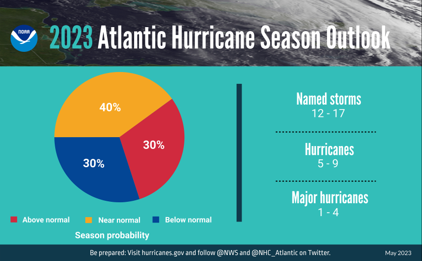
NOAA predicts less major development due to the EL Niño season this summer. El Niños are known for slowing down Atlantic hurricanes from developing. On the flip side El Niños tend to produce above normal African monsoons which effects coastal activity and warmer than normal sea surface temperatures.
Hurricane season is June 1st to November 30th. June tends to be a very slow month with very few named storms occurring in June especially in the Atlantic. However, the possibility if one can never be ruled out. With ocean temperatures rising and more moisture surrounding the Gulf of Mexico and Caribbean, the chance for a hurricane is always there. Historically only a few major storms have hit the US in June and none since 1986 so the chances are very low for any major hurricanes.
This doesn’t mean the chance for any tropical cyclones is none. In fact hurricane season is just getting started. With a few weeks left in June, its best to start being more aware of tropical developments and start getting prepared if a hurricane comes to your area. Hurricane preparedness tips can be found on on this site, just check out the Hurricane Preparedness Tips.

[wpcode id=”41149″]
Extended Outlook
Looking ahead, we can see a quiet Atlantic after our previously discussed tropical wave moves out. The high shear makes it hard for much development in the Atlantic for the rest of June into early July. This is common as the Atlantic doesn’t start to pick up much until August on average. The Pacific shows some possible developments with the Climate Prediction Center (CPC) projecting about a 40% chance of some formations so that is definitely something to keep watch of as we head into next week. It does seem that much of the Pacific development would head westward as predicted by the CPC. Looking at the end of June the Pacific seems to quiet down for the start of July.

[wpcode id=”41149″]
Conclusion
As we continue deeper into to hurricane season we must watch out for some possible developments in both the Atlantic and Pacific. The Atlantic is definitely the better one to look out for in terms of actual development within the next few days so keep and eye out for that. Shear in the Atlantic should help keep storms out of the US for the near future. Always be sure to keep up with the tropics as hurricane season starts to ramp up in late July.


Excellent forecast.