
As an arctic air mass settles south during the day on Sunday it will spawn showers and storms along the leading edge. The showers and storms along the front may be strong to severe. Depending on how storms orient along the front, where the area of surface low pressure forms, and how storm motions arrange, the tornado threat may be increased or reduced.
The setup
An area of mid-level low pressure is going to move ashore along the California coast Saturday and then swing across the Rockies and into the southeast on Sunday. In the process is will get stretched and torn apart at the mid-levels, but retain enough organization to spawn an area of low-level and surface low pressure.
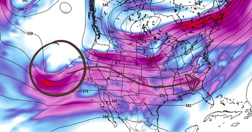
Ahead of the surface low, a warm front will lift north across South Mississippi. As it lifts north, some showers and elevated, but not surface-based, thunderstorms may develop along it. These elevated storms would have a lower tornado threat, but perhaps a higher hail threat. In general, these storms would have a chance to produce heavy rain, windy gusts up with 60mph and hail up to the size of quarters.
As the area of surface low pressure zips northeast along the front (as the front is moving southeast) it will take a lot of the dynamics with it, leaving a short window of opportunity for severe weather to occur for southern Mississippi.
Most likely in the space a few hours after the warm front passes and an hour before the cold front moves through.
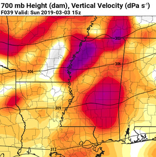
There ends up being a very cool atmospheric phenomenon that is showcased in this event. The mid-level vertical motion, identified by the GFS computer weather model, is actually during the morning hours along the warm front as it lifts north ahead of the surface area of low pressure.
While the highest low-level vertical motion is in the afternoon as the cold front passes through the area.
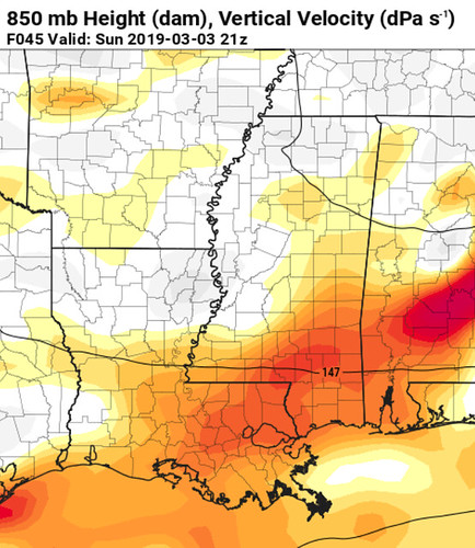
This happens due to the way warm fronts and cold fronts work. A cold front is digging under the warm air and pushing up on the air lower to the ground. While a warm front is gliding up over cooler air and pushing up air that is already a bit higher in the atmosphere.
Once the front passes through the area, much colder air settles in behind it. Temperatures will fall into the 30s Sunday night and into Monday morning. That will set the stage for three nights (Tuesday night, Wednesday night and Thursday night) for possible late-season frosts.
The severe weather threats
It looks like South Mississippi may be spared the worst of the weather again. That is welcomed news to an area that, during the last 10 years has seen its fair share of severe weather.
Right now, the main concerns are for heavy rain, frequent lightning, wind gusts up to 60mph, hailstones up to the size of quarters and the potential for a tornado or two.
The most likely scenario for a tornado would be for a weak (EF-0 or EF-1) tornado. While EF-2 or EF-3 tornadoes can’t be ruled out, the atmosphere doesn’t appear to be set up to support tornadoes that strong.
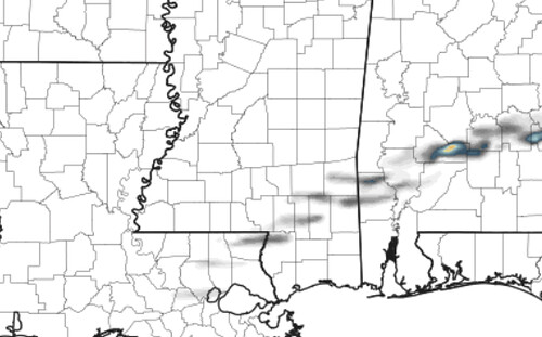
The Updraft Helicity streaks don’t show numbers high enough to support stronger tornadoes. Generally there need to be colors in yellow, orange and red on the map to be concerned about the threat for strong tornadoes.
While strong tornadoes may not be a big concern, hail on the other hand, will be. And here is why:
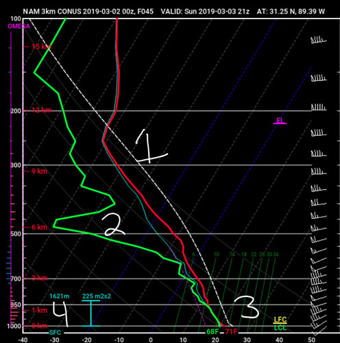
1. here is plenty of CAPE in the atmosphere – and it is deep. The instability in the storms goes from the surface all the way up to about 30,000 feet. That means storms will be tall, with a large section of the cloud below freezing.
2. There is dry air aloft. And dry air often aides in the development of larger hailstones. If it is too saturated within the near-storm environment, hail can be more difficult to build.
3. Surface temperatures will be around 70 degrees with an above-freezing section of the atmosphere below 10,000 feet thick. That will help any hailstone that is created, stay frozen as it falls toward the ground.
4. The Effective Inflow Layer is sheared enough to promote the development of organized storms in the lower levels that will help any mesocyclone sustain itself for longer – thus increasing the hailstone size within said storm.
Timeline
The first round of rain will move through the area in the morning before sunrise as the warm front moves through. These storms will have rain and wind, with some very small hail.
The next round will move through the area between 1p and 9p. The storms will move from west to east along a front that will be oriented from SW to NE.
Storms will be moving between 30mph and 50mph. So if a warning is issued for your area, please take cover as soon as possible as storms will be moving pretty quickly.
Then the cold
After the storms move through, colder air is going to pour into the area.
Temperatures will fall from the mid 70s on Sunday afternoon into the upper 30s by Monday morning. Highs will be in the 40s and 50s Monday, Tuesday and Wednesday.
Overnight lows on Tuesday and Wednesday will likely dip down to near or below freezing.
Wind speeds, cloud cover and higher dewpoints may keep the area from a frost on Monday night and into Tuesday morning, but the area may not be as lucky on Wednesday morning.
The bottom line
Between 1p and 9o Sunday there will be a chance for severe weather in South Mississippi.
Not every storm will be severe. I probably don’t drive that point home enough. Not every storm will have wind gusting higher than 60mph or quarter-sized hail. But a lot of storms will have heavy rain, frequent lightning, gusty wind and/or small hail.
And every storm will have rain, lightning and some wind.
When we predict the potential for severe weather, it doesn’t guarantee you will get the severe weather. And just because we say “not everyone will see a severe storm” doesn’t mean you can turn a blind eye to the weather.
We do our best to get you prepared for a reasonable worst-case scenario. And Sunday, that is the potential for a handful of severe storms, some with wind gusting more than 60mph and with hail up to the size of quarters. And the possibility that there may be a tornado.
And we don;t know where that will be yet.
Sadly, we don’t have the technology to predict where a tornado will develop more than a few hours in advance.
I just ask that you have a NOAA Weather Radio and a weather app on your phone that can ping you if a warning is issued for your area.


