Happy Sunday folks! The heat continues today with temperatures in the mid-to-lower 90s and southerly winds less than 5mph. Dewpoints will sit around the lower 70s allowing the heat index to approach 100F this afternoon. There is the possibility for a stray shower/thunderstorm in the afternoon, but overall skies will remain mostly sunny and dry throughout the day.

As has been the theme for most of this summer, subtropical ridging continues to influence the weather over the U.S. and SW Mississippi, with an area of high pressure currently sitting over the South/Southeast. This is expected to last until the middle of next week when stronger ridging develops over the Western U.S. and off the Southeast Coast in the Atlantic, but for the next several days the weather will remain fairly consistent with mid-to-lower 90s and mostly sunny skies thanks to the sinking air from the area of high pressure.
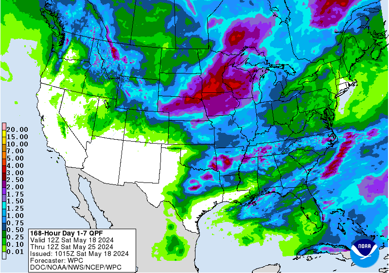
In fact, the next 7 days are expected to remain considerably dry over SW Mississippi with areas receiving no more than half an inch of rain. With the high pressure in place, any sources of lift in the atmosphere will primarily come from the sun creating pop-up thunderstorms in the afternoon. These storms could produce heavy rainfall rates with the high precipitable water values in the atmosphere, but they are unlikely to last very long as they tend to pulse and collapse on themselves.
The above GIF is the simulated reflectivity (otherwise known as the radar/precipitation) across SW Mississippi from 11am to 9pm. Thunderstorms begin to develop early this afternoon and last until early evening as the sun begins to go down. The initial storms will likely create outflow boundaries (cooler air flowing outward from the storms) which may initiate more thunderstorms along the boundaries and will bring some relief from the heat if lucky enough to experience one of these storms.
Day to Day Forecast
Today
Mostly sunny with a 30-percent chance for showers and thunderstorms in the afternoon/evening. Highs in the lower 90s. Heat Index values approaching 100F.
Tonight
Partly cloudy. Lows in the mid 70s.
Monday
Mostly sunny with a 30-percent chance for showers and thunderstorms in the afternoon/evening. Highs in the mid 90s. Heat Index values approaching 103F.
Monday Night
Partly cloudy. Lows in the lower 70s.
Tuesday
Mostly sunny with a 20-percent chance for showers and thunderstorms in the afternoon/evening. Highs in the lower 90s. Heat Index values approaching 102F.
Tuesday Night
Mostly clear. Lows in the lower 70s.
Wednesday
Mostly sunny with a 20-percent chance for showers and thunderstorms in the afternoon/evening. Highs in the mid 90s.
Wednesday Night
Mostly clear. Lows in the lower 70s.
Thursday
Mostly sunny with a 30-percent chance for showers and thunderstorms in the afternoon/evening. Highs in the mid 90s.
Thursday Night
Mostly clear. Lows in the lower 70s.
Friday
Mostly sunny with a 40-percent chance for showers and thunderstorms in the afternoon/evening. Highs in the lower 90s.
Friday Night
Partly cloudy. Lows in the lower 70s.
Saturday
Mostly sunny with a 60-percent chance for showers and thunderstorms in the afternoon/evening. Highs in the lower 90s.
Saturday Night
Mostly cloudy. Lows in the lower 70s.


