We’ve got a couple shots for rain here and there through the next few days. So far it looks like any risk for severe weather through today and tomorrow should be pretty limited.
Showers will try to sneak in as we move through the day and into the overnight hours tonight. You may catch a few rumbles of thunder, but for the most part this should just be regular rain. Then, as we move into tomorrow morning, it looks like we may see some bonafide storms try to move through.
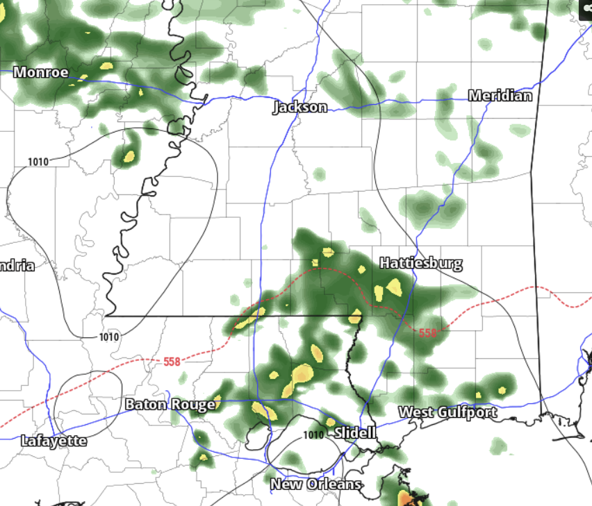
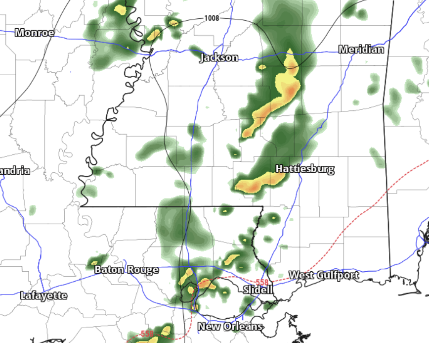
Any storms tomorrow morning should be just regular Gulf Coast storms, with no true risk for severe weather. Could a storm strengthen past “official” severe limits and warrant a warning from the NWS? Sure. It could happen. But the risk would be for heavy rain, lightning, wind gusts up to 60mph and small hail. The tornado threat is quite low for tomorrow.
Any storms will be rather scattered, with no “big batch” of storms anticipated. Things should clear out s we move through the night and set the stage for a pretty nice weekend.
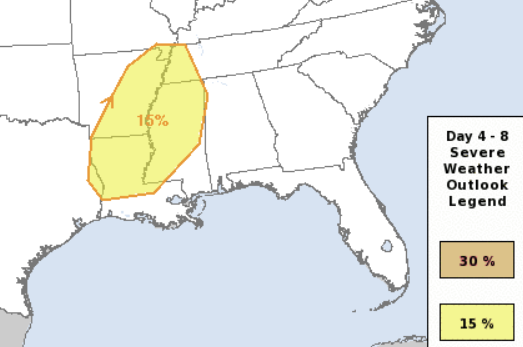
Then, next week it looks like we will have another shot for storms Monday night and into Tuesday morning. So far, the Storm Prediction Center is highlighting parts of the area with a Slight Risk for severe weather. That is a “2” on the 1-to-5 scale where “5” is the highest risk for the most significant severe weather
And given the data, I can’t argue with the SPC at all. Looking at the Skew-T data from the ECMWF model, it would appear that we have all of the correct ingredients in place late Monday night and into Tuesday morning for severe weather
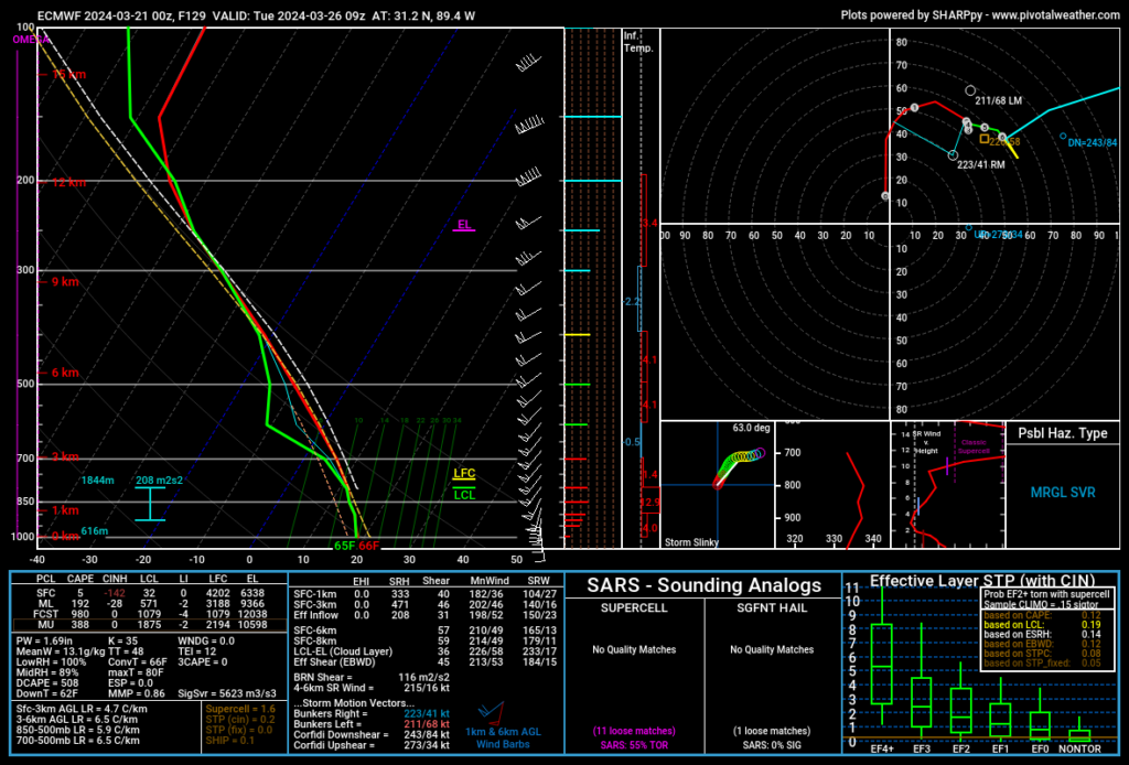
The only thing we seem to lack in the data this morning is instability – but models tend to under-forecast instability this far out in Spring.
That data currently supports a Karrie Meter of 3.18. But if we assume the models are under-cutting the surface temperatures and low-level warmth by as little as 10%, it bumps the Karrie Meter to a 4.38. And, for the purposes of this mental exercise, we assume it is under-forecasting and set parameters to the climatological normal for a late March / early April frontal passage, we get all the way up to a 5.46.
A bit like the SPC scale, the Karrie Meter is on a scale to “!0” where 10 is the highest risk for the most significant severe weather. That is why when you divide it in half, you often get the SPC Risk for the day.
So, this upcoming chance for storms next week deserves some attention. Not a reason to worry yet as many things can change, but it is definitely ‘on my radar’ so to speak.
REGIONAL DAY TO DAY FORECAST
Today: Mostly sunny this morning, then mostly cloudy with a slight chance of showers this afternoon. Highs in the lower 70s. East winds around 5 mph, becoming southeast this afternoon. Chance of rain 20 percent.
Tonight: Mostly cloudy with a 40 percent chance of showers. Lows in the lower 50s. Southeast winds around 5 mph.
Friday: A chance of thunderstorms. Showers. Highs in the upper 60s. Southeast winds 5 to 10 mph. Chance of rain 80 percent.
Friday Night: Mostly cloudy. A chance of showers and thunderstorms in the evening. Lows in the mid 50s. Southwest winds around 5 mph, becoming northwest with gusts up to 20 mph after midnight. Chance of rain 40 percent.
Saturday: Partly sunny in the morning, then clearing. Windy with highs in the lower 70s. North winds 20 to 30 mph with gusts up to 40 mph.
Saturday Night: Clear, cooler with lows in the mid 40s.
Sunday: Mostly sunny. Highs in the lower 70s.
Sunday Night: Mostly cloudy. Not as cool with lows in the mid 50s.
Monday: Mostly cloudy. A slight chance of showers and thunderstorms in the afternoon. Breezy with highs in the mid 70s. Chance of rain 20 percent.
Monday Night: Mostly cloudy with storms possible late. Breezy with lows in the lower 60s. Chance of rain 60 percent.
Tuesday: Partly sunny with a chance of thunderstorms. A chance of showers. Highs in the mid 70s. Chance of rain 50 percent.
Tuesday Night: Partly cloudy. A chance of showers and thunderstorms, mainly in the evening. Lows in the mid 50s. Chance of rain 20 percent.
Wednesday: Clearing skies.. Highs in the upper 70s.


