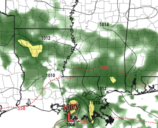
After a few chilly mornings, things are about to shift back toward something a bit more typical for late March standards. Tomorrow, as the high pressure moves east, we’ll start to feel more southerly winds. These winds will bring more moisture our way, setting the stage for a new weather system on Friday. This system isn’t expected to bring severe weather, but we’ll likely see most of the rain and storms in the afternoon.
Then, as we head into the weekend, we can look forward to cooler and drier weather thanks to northerly winds and a calmer weather pattern setting in.
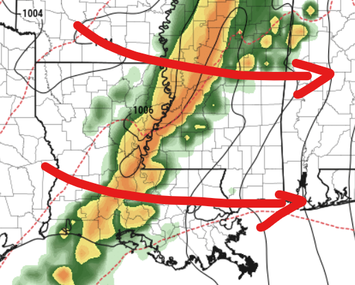
Looking further ahead to early next week, another system could stir things up again as it moves across the upper plains. This could lead to strong winds both at high altitudes and on the ground, potentially fostering the development of very organized storms, including an increased chance for severe weather and tornadoes.
The Euro model shows a line of storms moving through Monday night and through Tuesday morning. This model holds off the risk for storms ahead of the line, which may limit the risk for more tornadoes, but it wouldn’t mean a “zero risk” with the chance for tornadoes along the line, too.
However, a weather system off the Carolinas might limit the moisture coming our way, which could reduce the severity of the storms. But, if conditions change and we see more moisture, or if the storms can draw from a more moisture-rich environment, especially south of the I-20 corridor, there could be a risk of severe weather.
Since this is still a few days away, we’re bound to see some model changes and, thus, changes to the forecast. Along with the potential for severe weather, we’re also keeping an eye on the possibility of strong winds due to pressure differences in the area, particularly from Monday into Tuesday. There are still some uncertainties about how all this will unfold, but we should have a clearer picture as the event draws nearer.
REGIONAL DAY TO DAY FORECAST
Today: Sunny. Highs in the lower 70s. West winds around 5 mph.
Tonight: Partly cloudy. Lows in the lower 40s. South winds around 5 mph in the evening, becoming light and variable.
Thursday: Mostly sunny in the morning, then becoming mostly cloudy. Highs in the lower 70s. Northeast winds around 5 mph, becoming southeast in the afternoon.
Thursday Night: Mostly cloudy with some rain possible – mainly after midnight. Lows in the lower 50s. Southeast winds 5 to 10 mph. Chance of rain 20 percent.
Friday: Showers likely. A slight chance of storms. Highs in the upper 60s. East winds 5 to 10 mph, becoming south in the afternoon. Chance of rain 60 percent.
Friday Night: Mostly cloudy. A chance of thunderstorms with a slight chance of showers in the evening. Lows in the mid 50s. Chance of rain 30 percent.
Saturday: Partly sunny in the morning, then clearing. Highs in the lower 70s.
Saturday Night: Clear. Lows in the mid 40s.
Sunday: Sunny. Highs in the lower 70s.
Sunday Night: Mostly cloudy. Lows in the mid 50s.
Monday: Mostly cloudy. A slight chance of showers and thunderstorms in the afternoon. Highs in the mid 70s. Chance of rain 20 percent.
Monday Night: Mostly cloudy with a chance of showers and thunderstorms. Lows in the upper 50s. Chance of rain 42 percent.
Tuesday: Mostly sunny with a chance of showers and thunderstorms. Highs in the mid 70s. Chance of rain 40 percent.


Never seen a 42% chance of rain (Monday night)