Stormy and muggy as high and low pressure send moisture into the South: Southeast Weather Forecast – 6/30/22
Author: Gabriel Taylor
|| Published: 6/30/2022 at 11:00am
The Southeast is expected to remain warm and muggy the next few days with plenty of rainfall. Daily scattered showers and thunderstorms will be fueled by the summer sun and the high moisture content with dew points in the lower to mid 70s. This is a result of a moisture-favorable weather pattern with an area of high pressure just off the Southeast Coast and a disturbance along the shoreline of Texas.
The clockwise flow around the high pressure and counterclockwise flow around the low pressure are allowing for Gulf moisture to encroach all along the Gulf Coast and well inland across the Southeast. Over the next few days the area of high pressure will persist, continuing to bring moisture as low pressure moves northward over Texas bringing heavy rainfall.
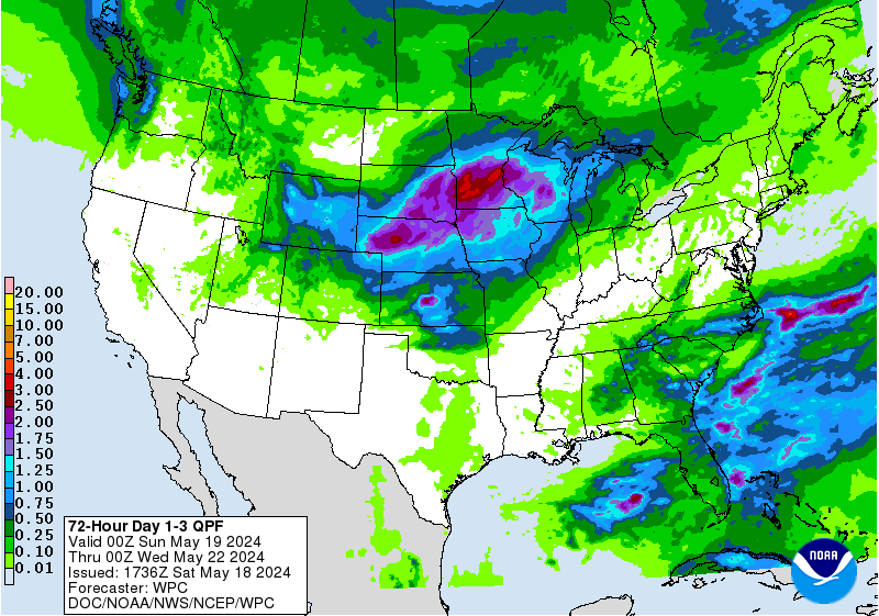
72 Hour Day 1-3 QPF // Courtesy: NWS Weather Prediction Center
Rainfall amounts will be quite high across the Southeast with localized areas exceeding 2″ over the next few days. Most of this rainfall will occur in the afternoons/evenings as the sun creates instability/fuel for the storms, leaving the mornings to be the driest and best time of the day for outdoor activities, although expect cloud coverage throughout most of the next 3 days. The disturbance/low pressure will bring the heaviest rainfall to the shoreline of Texas with rainfall amounts exceeding 3″ through today (6/30) and tomorrow (7/1).
Temperatures will range from the lower 80s to lower 90s across the region today, which is remarkably cooler than it has been the last few weeks. This is partly due to increased cloud coverage from the abundance of moisture and instability, along with sheared clouds from the Gulf disturbance being spread across the region. This will help decrease the amount of solar radiation reaching the surface keeping temperatures cooler; however, instability will still be sufficient enough for afternoon thunderstorms.
3-Day Southeast City Forecasts
Dallas, TX
Thursday
Friday
Saturday
High: 98F
High: 94F
High: 94F
Low: 76F
Low: 75F
Low: 78F
Precip: None
Precip: None
Precip: 30%
Houston, TX
Thursday
Friday
Saturday
High: 87F
High: 87F
High: 91F
Low: 77F
Low: 77F
Low: 77F
Precip: 70%
Precip: 60%
Precip: 40%
New Orleans, LA
Thursday
Friday
Saturday
High: 87F
High: 88F
High: 88F
Low: 78F
Low: 79F
Low: 79F
Precip: 90%
Precip: 80%
Precip: 80%
Little Rock, AR
Thursday
Friday
Saturday
High: 92F
High: 91F
High: 91F
Low: 72F
Low: 73F
Low: 73F
Precip: None
Precip: 30%
Precip: 40%
Memphis, TN
Thursday
Friday
Saturday
High: 90F
High: 92F
High: 92F
Low: 73F
Low: 74F
Low: 75F
Precip: 20%
Precip: 40%
Precip: 50%
Birmingham, AL
Thursday
Friday
Saturday
High: 86F
High: 86F
High: 88F
Low: 71F
Low: 70F
Low: 72F
Precip: 50%
Precip: 60%
Precip: 50%
Atlanta, GA
Thursday
Friday
Saturday
High: 85F
High: 82F
High: 84F
Low: 70F
Low: 69F
Low: 71F
Precip: 40%
Precip: 70%
Precip: 50%
Author of the article:
Gabriel Taylor
Gabriel Taylor is an upcoming Junior studying Meteorology at Florida Institute of Technology. He enjoys forecasting and watching the weather whether it be in his hometown in New Jersey or at school in Florida.