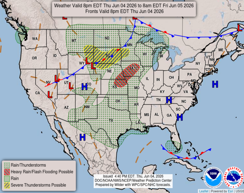
The classic summer weather pattern remains locked in across the South over the next few days. Expect hot and humid conditions each day with scattered afternoon and evening thunderstorms developing from Texas through Georgia. Although not everyone will see rain at the same time, heavy downpours, lightning, and gusty winds could lead to travel delays into your weekend.
Today
Currently, across the region, showers are moving in from the messy low-pressure system out in the Gulf, which is bringing rounds of heavy rainfall into our area. Through the rest of your evening, residents in Lower Mississippi, Louisiana, and practically all the way across the Gulf Coast can expect scattered storms stemming from this Gulf system.
Looking into the overnight hours, more storms are expected across the Western side of the region, impacting Texas and most of Louisiana.
Extended
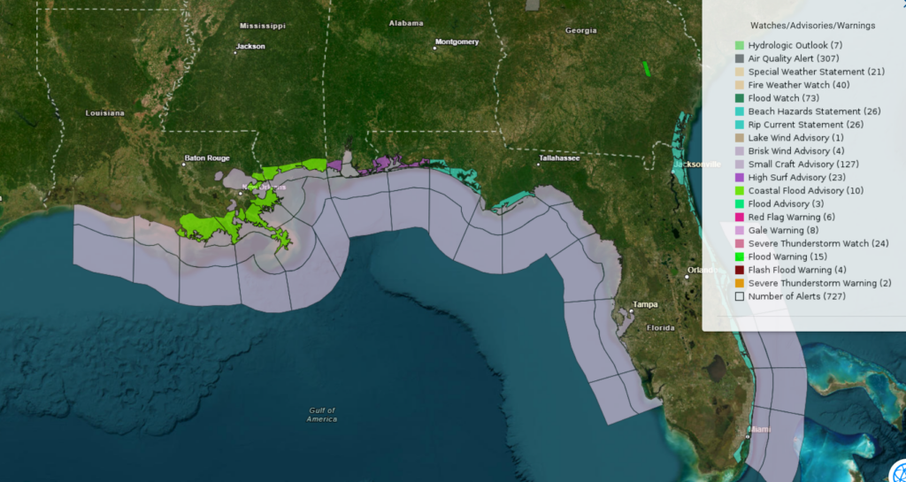
Moving into the weekend, it seems to be pretty similar to today with bands moving North off the Gulf, bringing rainfall to much of the South. Most of the Gulf Coast is under marine warnings due to this storm, so be extra cautious while boating or swimming if you are making your way to the Gulf this weekend.
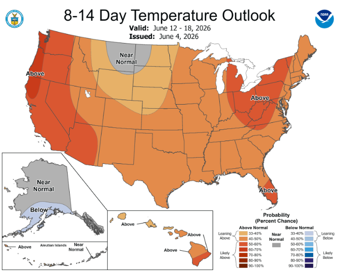
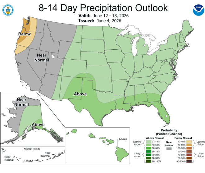
The CPC (Climate Prediction Center) is predicting a warm and wet next 8-14 days for our area. Nothing too crazy here, just a typical June forecast for the South.
StormVista’s 1-5 day forecast shows again, rounds of precipitation moving in from the Gulf over the next few days. If you are heading for the beaches, be sure to look out for potential rip currents from the Gulf storm, and monitor the radar for any afternoon storms moving in to ruin your vacation. You can expect sunny mornings and steamy afternoons along the coast as summer is starting to get into full swing.
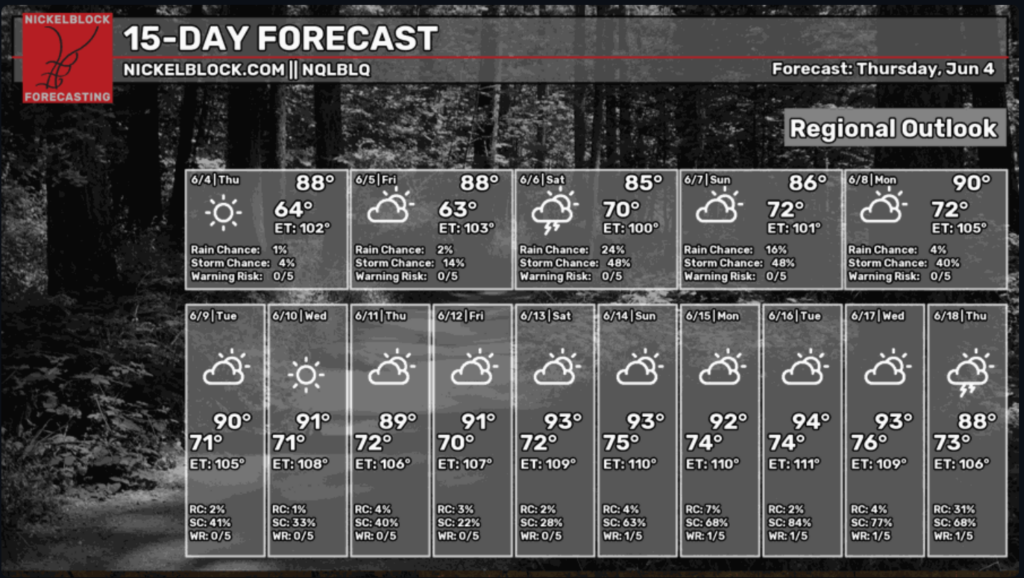
Through the end of the week, expect a mix of sun and clouds with highs in the upper 80s and lows in the 60s, along with only a few scattered showers and storms, mainly toward Saturday. By early next week, temperatures are looking to climb into the upper 80s and low 90s as the chances for rain drop and the skies clear a bit more. By mid to late next week, a full summer pattern sets in with highs in the low 90s with warm humid nights in the 70s and some isolated afternoon storms.
Travel Forecast
Tallahassee, FL: Friday, June 5: High of 88°F and Low of 67°F. Mostly sunny to partly cloudy with a slight (5%) chance of rain. Great for outdoor traveling!
Saturday, June 6: High of 91°F and Low of 68°F. Partly cloudy skies with a small chance of precipitation.
Sunday, June 7: High of 92°F and Low of 69°F. Mostly cloudy with a slight chance of afternoon showers or thunderstorms.
Atlanta, GA: Friday, June 5: Mostly sunny and warm with highs around 85°F and overnight lows near 65°F. Excellent conditions for flying and outdoor activities.
Saturday, June 6: Partly cloudy skies with a high near 86°F and a mostly dry day. Sunday, June 7: High near 86°F. Humidity increases, bringing a 55% chance of scattered afternoon showers and thunderstorms.
Mobile, AL: Friday, Jun 5: High of 90°F/ Low 67°F. Mostly sunny with very light winds and no rain expected.
Saturday, Jun 6: High 91°F / Low 69°F. Partly cloudy and warm. Perfect for outdoor activities.
Sunday, Jun 7: High 92°F / Low 69°F. Mostly cloudy but conditions remain dry.
Birmingham, AL: Friday, June 5: Mostly sunny and very warm with a high of 88°F and a low near 65°F. Ideal for outdoor activities and travel.
Saturday, June 6: Partly cloudy with highs reaching 89°F and lows near 71°F. A stray afternoon or evening shower is possible, but the majority of the day remains dry.
Sunday, June 7: Scattered thunderstorms and rain showers are likely throughout the day, bringing the high down to 84°F.
Jackson, MS: Friday, June 5: Mostly sunny and pleasant. High of 89°F, low of 71°F. Minimal rain chances (around 10%).
Saturday, June 6: Partly cloudy with scattered afternoon thunderstorms. High of 84°F, low of 73°F. Chance of rain is around 50-60%.
Sunday June 7: Thunderstorms likely throughout the day. High of 86°F, low of 74°F. Rain probability increases to 60-70%.
New Orleans, LA: Friday, June 5: High 83°F, Low 75°F. Mostly cloudy with the chance for showers and afternoon thunderstorms. Currently, a minor Coastal Flood Advisory is in effect due to breezy easterly winds from the Gulf system.
Saturday, June 6: High 83°F, Low 76°F. Muggy with scattered heavy thunderstorms likely, particularly in the afternoon.
Sunday, June 7: High 86°F, Low 76°F. Warm with small chances of showers and thunderstorms throughout the day.
Baton Rouge, LA: Friday, June 5: High of 86°F, Low of 75°F. A mix of sun and clouds in the morning, followed by scattered afternoon thunderstorms and heavy rain.
Saturday, June 6: High of 84°F, Low of 74°F. Cloudy and humid with widespread showers and thunderstorms, particularly in the afternoon.
Sunday, June 7: High of 86°F, Low of 75°F. Partly sunny but warm, with on-and-off showers and a likely chance of afternoon thunderstorms.
Shreveport, LA: Friday, June 5: High near 86°F / Low 73°F. Partly cloudy with a 40% to 50% chance of afternoon showers.
Saturday, June 6: High near 86°F / Low 74°F. Mostly cloudy with a high probability (70%+ chance) of scattered thunderstorms.
Sunday, June 7: High near 86°F / Low 75°F. Thunderstorms remain likely throughout the day.
Houston, TX: Friday, June 5: High 85°F. Variable cloudiness with periods of heavy rain and gusty afternoon thunderstorms.
Saturday, June 6: High 84°F. Tropical moisture moves into Southeast Texas, driving widespread, potentially heavy downpours in the afternoon.
Sunday, June 7: High 86°F. Humid with lingering sea-breeze showers and scattered afternoon thunderstorm activity.
I-10: Expect warm, mostly dry conditions across the Southwest and Florida, while scattered afternoon thunderstorms will impact sections of Louisiana and Mississippi through the weekend. Winds will generally be light to moderate, though occasional gusts exceeding 20 mph may affect parts of the Gulf Coast.
I-20: Expect mild, mostly dry conditions across the western side, with afternoon highs ranging from the 80s to the 90s. The eastern and central regions will see occasional showers and thunderstorms, particularly in Georgia and western sections, but winds will typically remain below 20 mph.
I-49: Travelers through Louisiana and Arkansas can expect warm, muggy conditions with highs consistently reaching into the upper 80s to low 90s, with scattered afternoon showers and thunderstorms capable of heavy downpours.
I-55 & I-59: Travel conditions along I-55 and I-59 are favorable, with milder temperatures and dry conditions. However, expect scattered afternoon showers and brief, isolated thunderstorms across the southern segments through the weekend.
I-65: The I-65 corridor will see generally mild and dry conditions over the next three days with mostly clear skies. However, travelers near the Gulf Coast should watch for breezy winds and isolated showers.
I-75: Hot, humid weather stretching into the upper 80s and low 90s with afternoon and evening thunderstorms. Conditions are mostly dry in the morning, but scattered heavy downpours may cause temporary visibility problems and hydroplaning risks for afternoon travelers.


