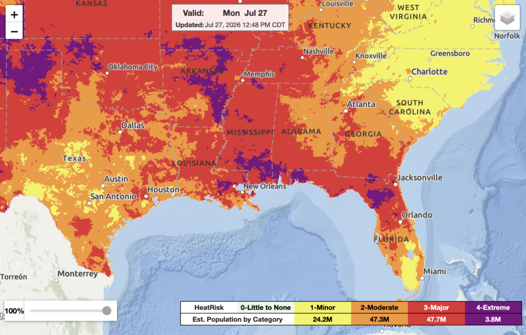
Dangerous heat is being felt around our region, especially near the Gulf Coast. The heatwave will be felt throughout the rest of this week. Maximum heat indices could reach 105 to 115 F. Make sure to protect yourselves from the heat by staying hydrated, having access to A/C, limiting your time outdoors during the hottest hours of the day, and checking up on your peers. Remember, if your pets also need to be taken care of when the summer sun is beating down!
Tonight
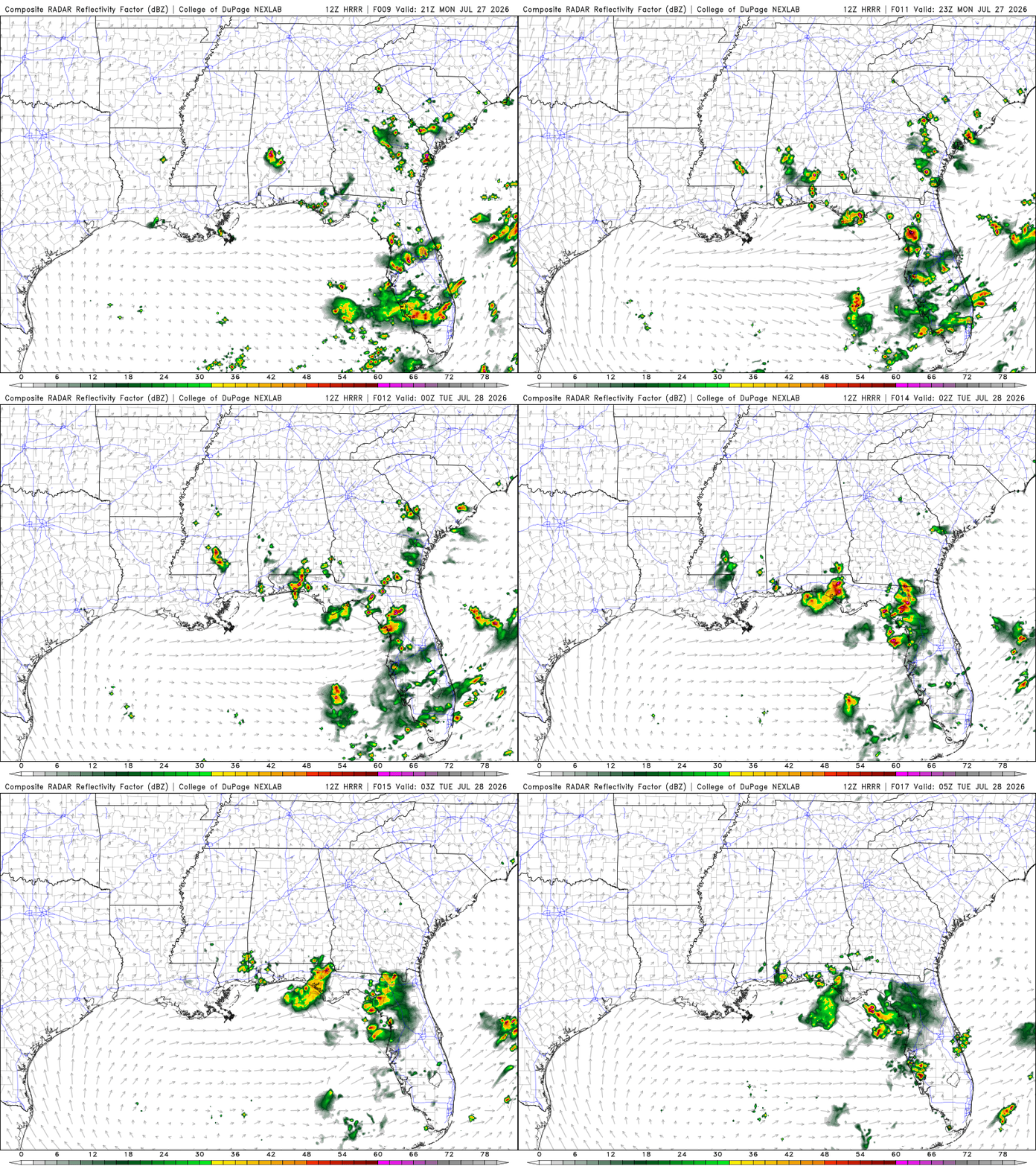
Possible thunderstorm moving southwest in southern MS near the MS/ LA border around the later afternoon/ early evening hours. Possible isolated showers and thunderstorms in Southern AL during the late evening. Scattered showers and thunderstorms through Western FL and the FL Panhandle. Could linger into the GA/FL state line. Showers and thunderstorms will continue in western FL overnight, and isolated flooding is possible. Scattered showers and thunderstorms in eastern GA near the GA/ SC border during the late afternoon/ evening hours.
Today’s Interstate Forecast
I-10: Showers and thunderstorms in the FL Panhandle for the rest of the evening into the nighttime hours.
I-20: Scattered showers and thunderstorms at the MS/ AL border until the late evening.
I-49: Clear.
I-55: Isolated showers and thunderstorms near southern MS until around 9 pm.
I-59: Isolated showers and thunderstorms near southern MS until around 9 pm. Scattered showers and thunderstorms at the MS/ AL border until the late evening.
I-65: Possible isolated showers and thunderstorms near central southern AL.
I-75: Scattered showers and thunderstorms throughout FL and in southern GA.
3 Day Traveling Forecast
KHOU – Houston: No weather is anticipated for the next three days!
KSHV – Shreveport: No weather is anticipated for the next three days!
KBTR – Baton Rouge: No weather is anticipated for the next three days!
KMSY – New Orleans: A slight chance of thunderstorms overnight. Possible delays at the airport due to lightning.
KJAN – Jackson: Chance for showers Wednesday night. Should not lead to flight delays.
KBHM – Birmingham: Chance of thunderstorms on Wednesday. Possible delays at the airport due to lightning.
KMOB – Mobile: Chance of thunderstorms all three days. Possible delays at the airport due to lightning.
KATL – Atlanta: Chance of thunderstorms tonight. Possible delays at the airport due to lightning.
KTLH – Tallahassee: Chance of thunderstorms tonight and Wednesday. Possible delays at the airport due to lightning.
3 Day City Forecast
Houston, TX:
Today – Sunny. High of 97 F. Mostly clear overnight. Low of 78 F. Mostly calm winds.
Tuesday – Hot. High of 98 F. Heat Advisory until 7 pm. Mostly clear overnight. Low of 79 F. Mostly calm winds.
Wednesday – Hot. High of 98 F. Mostly clear overnight. Low of 80 F. Calm winds.
Shreveport, LA:
Today – Hot. High of 99 F. Heat Advisory. Mostly clear overnight. Low of 79 F. Calm winds.
Tuesday – Hot. High of 100 F. Heat Advisory until 8 pm. Mostly clear overnight. Low of 80 F. Mostly calm winds.
Wednesday – Hot. High of 99 F. Partly cloudy overnight. Low of 80 F. Calm winds.
Baton Rouge, LA:
Today – Hot. High of 96 F. Heat Advisory until 8 pm. Partly cloudy overnight. Low of 78 F. Calm winds.
Tuesday – Hot. High of 97 F. Heat Advisory from 11 pm until 8 pm. Mostly clear overnight. Low of 78 F. Calm winds.
Wednesday – Hot. High of 97 F. Partly cloudy overnight. Low of 79 F. Calm winds.
New Orleans, LA:
Today – Hot. High of 95 F. Heat Advisory until 8 pm. Partly cloudy overnight. Low of 81 F. Calm winds.
Tuesday – Hot. High of 96 F. Extreme Heat Warning from 11 am to 8 pm. Mostly clear overnight. Low of 81 F. Mostly calm winds.
Wednesday – Hot. High of 95 F. A slight chance of thunderstorms overnight. Low of 81 F. Mostly calm winds.
Jackson, MS:
Tonight – Mostly clear. Heat Advisory until 9 pm. Low of 77 F. Calm winds.
Tuesday – Hot. High of 99 F. Extreme Heat Warning from 11 am until 9 pm. Mostly clear overnight. Low of 78 F. Calm winds.
Wednesday – Hot. High of 98 F. Partly cloudy overnight. Chance for showers. Low of 76 F. Calm winds.
Birmingham, AL:
Tonight – Mostly clear with patchy fog. Low of 76 F. Heat Advisory. Calm winds.
Tuesday – Sunny with patchy fog. High of 97 F. Heat advisory until 9 pm. Partly cloudy overnight. Low of 77 F. Mostly calm winds.
Wednesday – Partly sunny. Chance of thunderstorms. High of 91 F. Mostly clear overnight. Low of 70 F. Mostly calm winds.
Mobile, AL:
Tonight – Partly cloudy. Slight chance of thunderstorms. Heat Advisory until 8 pm. Low of 79 F. Mostly calm winds.
Tuesday – Sunny. Slight chance of thunderstorms. High of 100 F. Heat Advisory from 10 am until 9 pm. Partly cloudy. Slight chance of thunderstorms. Low of 80 F. Mostly calm winds.
Wednesday – Sunny. Chance of thunderstorms. High of 100 F. Chance of thunderstorms and showers overnight. Low of 78 F. Mostly calm winds.
Atlanta, GA:
Tonight – Partly cloudy. Chance of thunderstorms. Low 75 F.
Tuesday – Mostly sunny. Heat Advisory from 12 pm until 8 pm. Partly cloudy overnight. Low of 76 F.
Wednesday – Mostly sunny. Clear overnight. Low of 71 F.
Tallahassee, FL:
Tonight – Heat Advisory until 8 pm. Severe Thunderstorm Warning until 8:30 pm. Low of 77 F.
Tuesday – Hot. Heat Advisory from 11 am until 8 pm. Partly cloudy overnight. Low of 79 F.
Wednesday – Mostly sunny. Thunderstorms likely. High of 97 F. Thunderstorms likely overnight. Low of 76 F.
Extended Regional Outlook
The CPC outlooks have our region feeling warmer than average, along with normal precipitation amounts.


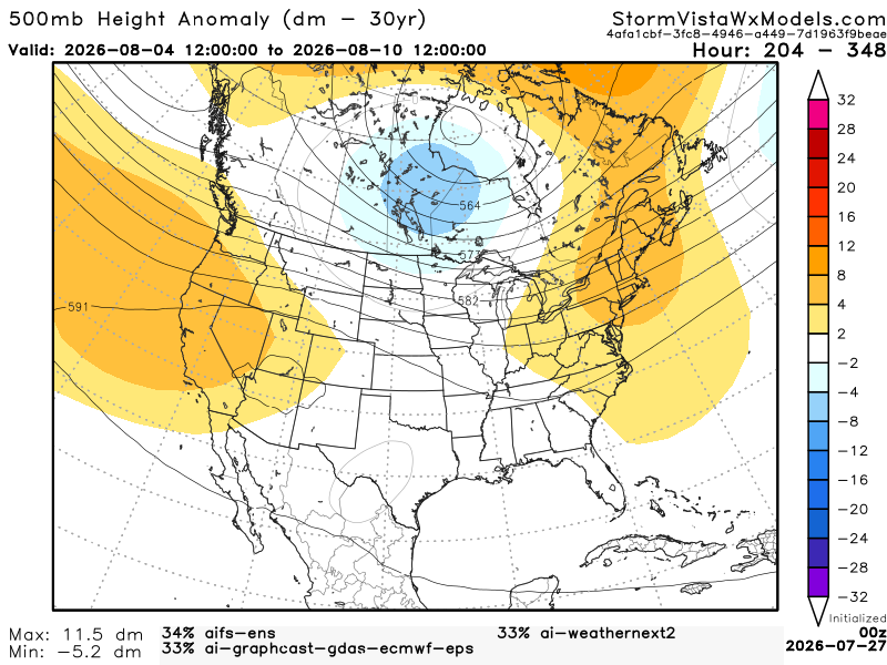
Below, we have 3 of the most accurate models blended into one model. This gives us an idea of the possible outcomes from August 4th (7 am) to August 10th (7 am). Based on this blend of models, the Southern region will most likely see slightly above-average temperatures and near-normal precipitation. We have no anomalies over our region, so no insane heat wave. We’ll still have the Gulf feeding warm, moist air into our area, so don’t rule out sea breeze thunderstorms during the afternoons.