Let me start by saying that this forecast may change. And is not set in stone. I really encourage everyone to check back every – at least! – 12 hours for an update until landfall on Sunday afternoon. Hurricane Ida is now forecast to become a Major Hurricane during the next 48 hours leading up to landfall. Rapid Intensification is currently in the forecast as it is anticipated to move over the ‘loop current’ in the Gulf of Mexico.
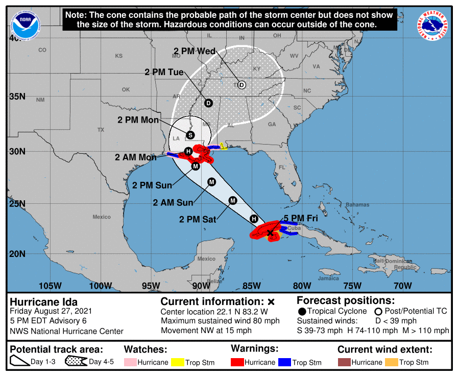
Looking at the Forecast from the National Hurricane Center, they are concerned about very heavy rain, flooding, wind, and a few tornadoes.


Looking at the Tropical Threat Index I’ve created, this lands at an 8.67 out of 10.

That is equal to where Laura was on this scale last year.
The Wind and Rainfall don’t get any higher on the scale. And the current peak surge estimate of 15ft is 1ft away from making this a more “impactful,” by the numbers, on this scale than Hurricane Laura and equal to Hurricane Katrina.
Now, this is just numbers on a page, and both of those storms will forever leave their mark on history for many different reasons. But it also means that this storm will have the numbers to do the same.
Keep in mind, this is a preliminary forecast that is subject to change given the nature of tropical forecasting. Please check back for updates.
Louisiana
St. Helena Parish
Timeline: Sunday 10am – Monday 4pm
Threats:
– 7″ to 10″ of rain
– Sustained wind up to 80mph
– Wind gusts up to 95mph
– Tropical tornadoes
Impacts: flooding, downed trees
Power Outage Risk: Very High
Tangipahoa Parish
Timeline: Sunday 10am – Monday 4pm
Threats:
– 7″ to 10″ of rain
– Sustained wind up to 80mph
– Wind gusts up to 95mph
– Tropical tornadoes
Impacts: flooding, downed trees
Power Outage Risk: Very High
Washington Parish
Timeline: Sunday 10am – Monday 4pm
Threats:
– 7″ to 10″ of rain
– Sustained wind up to 80mph
– Wind gusts up to 95mph
– Tropical tornadoes
Impacts: flooding, downed trees
Power Outage Risk: Very High
Livingston Parish
Timeline: Sunday 10am – Monday 4pm
Threats:
– 7″ to 10″ of rain
– Sustained wind up to 80mph
– Wind gusts up to 95mph
– Tropical tornadoes
Impacts: flooding, downed trees
Power Outage Risk: Very High
St. Tammany Parish
Timeline: Sunday 10am – Monday 4pm
Threats:
– 7″ to 10″ of rain
– Sustained wind up to 75mph
– Wind gusts up to 90mph
– Tropical tornadoes
Impacts: flooding, downed trees
Power Outage Risk: Very High
Mississippi
NEAR I-20
Copiah County
Timeline: Sunday 7pm – Monday 10pm
Threats:
– 6″ to 9″ of rain
– Sustained wind up to 50mph
– Wind gusts up to 65mph
– Tropical tornadoes
Impacts: flooding, downed trees
Power Outage Risk: High
Simpson County
Timeline: Sunday 7pm – Monday 10pm
Threats:
– 6″ to 9″ of rain
– Sustained wind up to 50mph
– Wind gusts up to 65mph
– Tropical tornadoes
Impacts: flooding, downed trees
Power Outage Risk: High
Smith County
Timeline: Sunday 7pm – Monday 10pm
Threats:
– 5″ to 8″ of rain
– Sustained wind up to 50mph
– Wind gusts up to 65mph
– Tropical tornadoes
Impacts: flooding, downed trees
Power Outage Risk: High
Jasper County
Timeline: Sunday 7pm – Monday 10pm
Threats:
– 4″ to 7″ of rain
– Sustained wind up to 45mph
– Wind gusts up to 60mph
– Tropical tornadoes
Impacts: flooding, downed trees
Power Outage Risk: Moderate
Clarke County
Timeline: Sunday 7pm – Monday 10pm
Threats:
– 4″ to 7″ of rain
– Sustained wind up to 45mph
– Wind gusts up to 60mph
– Tropical tornadoes
Impacts: flooding, downed trees
Power Outage Risk: Moderate
HIGHWAY 84 CORRIDOR
Lincoln County
Timeline: Sunday 4pm – Monday 7pm
Threats:
– 6″ to 9″ of rain
– Sustained wind up to 50mph
– Wind gusts up to 70mph
– Tropical tornadoes
Impacts: flooding, downed trees
Power Outage Risk: High
Lawrence County
Timeline: Sunday 4pm – Monday 7pm
Threats:
– 6″ to 9″ of rain
– Sustained wind up to 50mph
– Wind gusts up to 70mph
– Tropical tornadoes
Impacts: flooding, downed trees
Power Outage Risk: High
Jeff Davis County
Timeline: Sunday 4pm – Monday 7pm
Threats:
– 6″ to 9″ of rain
– Sustained wind up to 45mph
– Wind gusts up to 60mph
– Tropical tornadoes
Impacts: flooding, downed trees
Power Outage Risk: High
Covington County
Timeline: Sunday 4pm – Monday 7pm
Threats:
– 6″ to 9″ of rain
– Sustained wind up to 45mph
– Wind gusts up to 60mph
– Tropical tornadoes
Impacts: flooding, downed trees
Power Outage Risk: High
Jones County
Timeline: Sunday 4pm – Monday 7pm
Threats:
– 6″ to 9″ of rain
– Sustained wind up to 45mph
– Wind gusts up to 60mph
– Tropical tornadoes
Impacts: flooding, downed trees
Power Outage Risk: High
Wayne County
Timeline: Sunday 4pm – Monday 7pm
Threats:
– 4″ to 7″ of rain
– Sustained wind up to 45mph
– Wind gusts up to 60mph
– Tropical tornadoes
Impacts: flooding, downed trees
Power Outage Risk: Moderate
HIGHWAY 98 CORRIDOR
Pike County
Timeline: Sunday 1pm – Monday 4pm
Threats:
– 7″ to 10″ of rain
– Sustained wind up to 75mph
– Wind gusts up to 90mph
– Tropical tornadoes
Impacts: flooding, downed trees
Power Outage Risk: Very High
Walthall County
Timeline: Sunday 1pm – Monday 4pm
Threats:
– 7″ to 10″ of rain
– Sustained wind up to 70mph
– Wind gusts up to 85mph
– Tropical tornadoes
Impacts: flooding, downed trees
Power Outage Risk: Very High
Marion County
Timeline: Sunday 1pm – Monday 4pm
Threats:
– 7″ to 10″ of rain
– Sustained wind up to 65mph
– Wind gusts up to 80mph
– Tropical tornadoes
Impacts: flooding, downed trees
Power Outage Risk: Very High
Lamar County
Timeline: Sunday 1pm – Monday 4pm
Threats:
– 7″ to 10″ of rain
– Sustained wind up to 60mph
– Wind gusts up to 75mph
– Tropical tornadoes
Impacts: flooding, downed trees
Power Outage Risk: High
Forrest County
Timeline: Sunday 1pm – Monday 4pm
Threats:
– 7″ to 10″ of rain
– Sustained wind up to 55mph
– Wind gusts up to 70mph
– Tropical tornadoes
Impacts: flooding, downed trees
Power Outage Risk: High
Perry County
Timeline: Sunday 10am – Monday 1pm
Threats:
– 6″ to 9″ of rain
– Sustained wind up to 50mph
– Wind gusts up to 65mph
– Tropical tornadoes
Impacts: flooding, downed trees
Power Outage Risk: High
Greene County
Timeline: Sunday 10am – Monday 1pm
Threats:
– 6″ to 9″ of rain
– Sustained wind up to 50mph
– Wind gusts up to 65mph
– Tropical tornadoes
Impacts: flooding, downed trees
Power Outage Risk: High
HIGHWAY 26 CORRIDOR
Pearl River County
Timeline: Sunday 10am – Monday 4pm
Threats:
– 7″ to 10″ of rain
– Sustained wind up to 80mph
– Wind gusts up to 95mph
– Tropical tornadoes
Impacts: flooding, downed trees
Power Outage Risk: Very High
Stone County
Timeline: Sunday 10am – Monday 1pm
Threats:
– 6″ to 9″ of rain
– Sustained wind up to 75mph
– Wind gusts up to 90mph
– Tropical tornadoes
Impacts: flooding, downed trees
Power Outage Risk: Very High
George County
Timeline: Sunday 10am – Monday 1pm
Threats:
– 6″ to 9″ of rain
– Sustained wind up to 65mph
– Wind gusts up to 80mph
– Tropical tornadoes
Impacts: flooding, downed trees
Power Outage Risk: High
Alabama
Sumter County
Timeline: Sunday 4pm – Monday 7pm
Threats:
– 3″ to 6″ of rain
– Sustained wind up to 45mph
– Wind gusts up to 60mph
– Tropical tornadoes
Impacts: flooding, downed trees
Power Outage Risk: High
Choctaw County
Timeline: Sunday 1pm – Monday 4pm
Threats:
– 5″ to 8″ of rain
– Sustained wind up to 45mph
– Wind gusts up to 60mph
– Tropical tornadoes
Impacts: flooding, downed trees
Power Outage Risk: High
Washington County
Timeline: Sunday 1pm – Monday 4pm
Threats:
– 5″ to 8″ of rain
– Sustained wind up to 45mph
– Wind gusts up to 60mph
– Tropical tornadoes
Impacts: flooding, downed trees
Power Outage Risk: High
Coastal Communities
While I didn’t breakout coastal counties, do know that if you live along the coast between roughly Grand Chanier, Louisiana and Orange beach, Alabama you need to consult your local emergency management officials to see if a mandatory evacuation is in place.

Evacuations may be needed for a much larger area than you’d think at first glance.Notice the area with “6ft above ground level” stretches from Vermilion Bay all the way to the MS/AL border.
And up to 15 feet of surge is possible from the forecast from the National Hurricane Center

That is on top of the potential for much higher wind speeds, given you are right on the water. So, if you are ordered to evacuate, please listen. This is not going to be a fun storm to ‘ride out’ at home.


Harrison County in MS was never mentioned yet we are coastal MS – Gulfport, Biloxi, etc. And we took the worst hit during Katrina but were seldom mentioned then either! The focus seems to always be on New Orleans and never “our land mass.” What can you tell me about Harrison County and our outlook for Ida? Even the Weather Channel ignores us time after time. Thank you for everything you do!