Active and Thanskgiving are two words I wouldn’t put together in a sentence for a day full of food, but I’ll make an exception for weather! You’ve all probably seen by now that there is a chance of severe weather coming Monday into Tuesday, but it also looks like we may have a chance of rain on Turkey Day as well as the latter part of the weekend.
For the weekend, a cold front will dry out conditions a bit especially on Sunday. Temperatures will hover around the low 70s with a mix of clouds and sun.
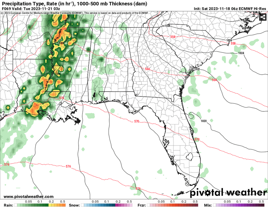
As much as I’d like to go into detail about Monday night’s severe weather chance, the GFS and Euro models are still out of alignment in terms of duration and overall impacts. The Euro model has the surface low developing out of Arkansas and the line of storms developing into a fairly organized squall line as it moves through Louisiana into Mississippi. This would mean that threats like hail, tornadoes and flash flooding would be higher but also more short-lived.

The GFS has the line of storms slightly less severe but the threats still possible. The main difference is how long it looks to hang around especially around the Gulf coast of MS/LA. I noticed that both the GFS and Euro have a “stalled front” look to them going into Tuesday, however the GFS takes this to heart and slows the front down right near the Gulf of Mexico. Despite having a very strong 500mb low coming behind it, it will lengthen the rain and thunderstorms into Wednesday.
My overall thoughts? I’m honestly going to wait a day to get some more short-range and better medium-range guidance before saying how long and how strong this will be, but I will hold it to both that we’ll get a significant amount of rain and most likely some severe storms no matter what.

For the rest of the week, temperatures look to take a slight dive into the 50s and 60s with lows in the 40s. Thanksgiving Day, we may see another chance of rain. Why? A similar reason we got the dreary rain last week. Another low from Mexico may work its way towards the Gulf coast with another batch of rain. This looks to be another rain event mostly for people in southeastern Louisiana and the MS/AL coast with some of the rain moving inland towards the southern end of the Pinebelt.
Conditions should dry out a bit for Friday and Saturday before another system may arrive Sunday, but we’ll have to wait and see what the timing of this is considering how far out the guidance is. Needless to say, plenty of rain is coming/possible for the next several days and it will definitely help with the drought, but we’ll definitely need to watch out for flooding concerns considering how dry the ground is. Have a good week and a happy Thanksgiving!
[wpcode id=”41179″]
Regional Day-to-Day Forecast
Today – Partly sunny, then gradually becoming sunny, with a high near 71. North wind 5 to 10 mph.
Tonight – Clear, with a low around 42. North northwest wind around 5 mph becoming calm in the evening.
Sunday – Mostly sunny, with a high near 70. Calm wind becoming north around 5 mph.
Sunday Night – A 20 percent chance of showers after midnight. Partly cloudy, with a low around 48. Calm wind becoming southeast around 5 mph.
Monday – A 30 percent chance of showers in the afternoon. Mostly cloudy, with a high near 74. Southeast wind 5 to 10 mph, with gusts as high as 20 mph.
Monday Night – A chance of showers, then showers and possibly a thunderstorm after midnight. Some of the storms could be severe. Low around 62. Southeast wind around 10 mph, with gusts as high as 25 mph. Chance of precipitation is 80%. New rainfall amounts between a quarter and half of an inch possible.
Tuesday – Showers likely and possibly a thunderstorms possible. Mostly cloudy, with a high near 70. South wind around 10 mph becoming west northwest in the afternoon. Winds could gust as high as 25 mph. Chance of precipitation is 60%.
Tuesday Night – A 30 percent chance of showers, mainly before midnight. Mostly cloudy, with a low around 49. North northwest wind around 10 mph, with gusts as high as 25 mph.
Wednesday – Partly sunny, with a high near 58. North northwest wind 5 to 10 mph, with gusts as high as 20 mph.
Wednesday Night – Partly cloudy, with a low around 42.
Thanksgiving Day – Mostly sunny, with a high near 57.
Thursday Night – Partly cloudy, with a low around 41.
Friday – Mostly sunny, with a high near 62.
[wpcode id=”41149″]


Tidbits isn’t, at this time, showing anything on Thanksgiving Day. If it ‘does’ rain on that day, of all days, at least we’ll know who to blame.