Aside from some fog this morning, it looks like the weather should be pretty nice today. A cold front will glide through, with little consequence, and it should set the stage for a decent weekend.
High pressure at the surface will quickly move into the region on Saturday, controlling the weather through much of the weekend. Conditions will be slightly cooler with a drier air mass in place. As high pressure shifts east on Sunday night, southerly flow will bring warmer conditions.
That southerly flow is what may fuel the chance for storms along the next front that pushes into the area by late Monday and into Tuesday.
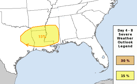
Currently the Storm Prediction Center has highlighted parts of the area with a Slight Risk for severe weather. That is a “2” on the 1-to-5 scale where “5” is the highest risk for the most significant severe weather.
The pivotal item to watch is the development of a surface area of low pressure. Where is form, how fast it forms, and where it moves will dictate the risk for storms and severe weather.
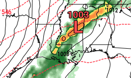
There are some inconsistencies in model runs regarding the timing and exact placement/track of the system, how much instability develops, and how fast is passes through. Any change to any of those will also change the overall impacts. Despite these challenges at a weather dude I’ve got to say, I still think there is some potential for severe storms late Monday into early Tuesday.
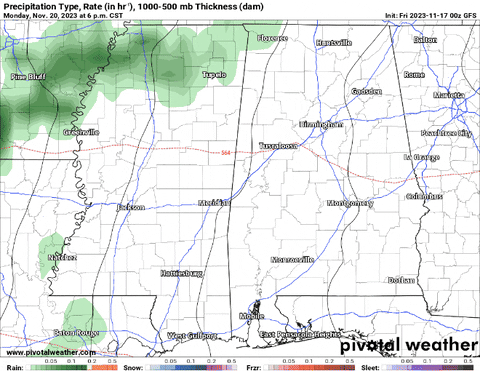
Below is an animation from the GFS computer weather model. It is a bit slower and drags out the risk for storms over a 12 hour window. This would likely limit the risk for severe weather, but may lead to a higher risk for flooding in some area (despite the drought).
Changes in model data and threat area are likely, so please monitor the latest forecast for the most up-to-date information.
The front, clouds, and rain will clear out of the area on Tuesday and into Tuesday night. High pressure will build southeast into the region on Wednesday into Thursday, bringing quiet weather. This will also bring a colder, drier air mass just in time for Thanksgiving.
[wpcode id=”41149″]
DAY TO DAY REGIONAL FORECAST
Tonight: Mostly cloudy. Patchy fog after midnight. Lows in the upper 50s. Northeast winds around 5 mph.
Friday: Patchy fog in the morning. Mostly cloudy. Highs in the mid 70s. North winds around 5 mph.
Friday Night: Mostly cloudy. Lows in the upper 50s. North winds 5 to 10 mph.
Saturday: Mostly sunny. Highs in the lower 70s. North winds 5 to 10 mph.
Saturday Night: Mostly clear. Cooler with lows in the mid 40s. North winds around 5 mph.
Sunday: Mostly sunny. Highs around 70.
Sunday Night: Mostly cloudy. A slight chance of showers after midnight. Lows in the lower 50s. Chance of rain 20 percent.
Monday: Mostly cloudy with a slight chance of thunderstorms. Showers likely, mainly in the morning. Highs in the mid 70s. Chance of rain 60 percent.
Monday Night: Showers likely with a slight chance of thunderstorms. Lows in the lower 60s. Chance of rain 70 percent.
Tuesday: Partly sunny. A chance of showers with a slight chance of thunderstorms in the morning, then a slight chance of showers in the afternoon. Highs in the upper 60s. Temperature falling into the mid 60s in the afternoon. Chance of rain 40 percent.
Tuesday Night: Mostly cloudy. Much cooler with lows in the mid 40s.
Wednesday: Mostly sunny. Cooler with highs in the upper 50s.
Wednesday Night: Mostly clear. Lows in the upper 30s.
Thanksgiving Day: Sunny. Highs around 60.


Tidbits is showing the Main Event moving through during the day on Tuesday. This is while seemingly everyone else is showing it moving through on Monday night/Tuesday morning. I’m wondering if that’s because Tidbits uses GFS and everyone else uses the EURO??