If you noticed some gusty winds during a fairly calm day yesterday, they’re here to stay over the weekend! Looking at the surface analysis, the strong mid-Atlantic high is creating a close-knit gradient across the eastern US which means that wind is blowing up the Gulf. Areas of southwest Mississippi and southeast Louisiana will have a wind advisory today and possibly tomorrow depending on how strong the winds are.
Today, we’ll have mostly cloudy skies due to the influx of mid-level clouds remaining over us for most of the day. These will begin to move out around sunset and we’ll have a clearer night ahead. Winds will still be gusting into the overnight hours so be wary of that if you’re outside. Winds will be a steady 10-15mph with 30 mph wind gusts.
Sunday will be another warm day with more of a mix of clouds throughout the day, building up around nighttime as the cold front sets up to our west. Winds will still be quite gusty as the day goes along and the humidity will start to pick up a bit into the evening hours.
Now let’s talk Monday:
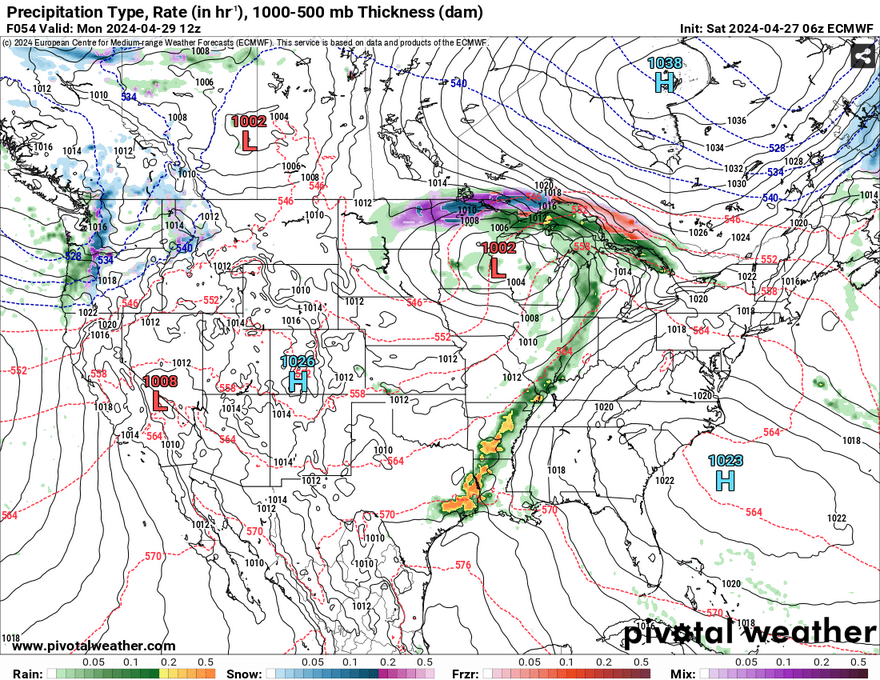
Beginning Monday morning, a shortwave trough will move northeast into the western Great Lakes region and churn up a line of storms from Arkansas to southeastern Texas. The SPC has put this at a marginal risk of severe weather and so far this rings true. The line looks fairly organized, but not very strong. That doesn’t mean that we don’t have anything to be concerned about.

As the storm evolves from the morning onward, we may see the southern portion of the MCS split off from the rest of the line. My thoughts are that the gradient wind I mentioned about this weekend will have a role in that. As the cold front butts with the strong high pressure system to the east, the MCS looks to weaken the further east it goes. The worst of the flash flooding and winds looks to be around southern Louisiana, the Delta region, and Arkansas. But this doesn’t mean that parts of southeast Mississippi and the Alabama coast won’t see any rain. We’ll likely see 1/2″-3/4″ of an inch before the storm leaves come Monday night.
I’ll have an update on Monday’s weather tomorrow in the weekly outlook.
[wpcode id=”41179″]
Regional Day-to-Day Forecast
Today – Partly sunny, with a high in the low to mid 80s. North wind 5 to 10 mph becoming south southeast 10 to 15 mph in the morning. Winds could gust as high as 30 mph.
Tonight – Increasing clouds, with a low in the low 60s. Southeast wind 10 to 15 mph, with gusts as high as 25 mph.
Sunday – A chance of drizzle in the afternoon. Partly sunny, with a high in the low 80s. South southeast wind 10 to 15 mph, with gusts as high as 30 mph.
Sunday Night – Mostly cloudy, with a low in the mid 60s. South southeast wind 5 to 15 mph, with gusts as high as 25 mph.
Monday – Showers likely and possibly a thunderstorm in the afternoon. Mostly cloudy, with a high in the low 80s. South southeast wind 5 to 10 mph, with gusts as high as 25 mph. Chance of precipitation is 60%. New rainfall amounts between a half and three quarters of an inch possible.
Monday Night – A chance of showers and thunderstorms overnight. Mostly cloudy, with a low in the mid 60s. South wind 5 to 10 mph becoming light south southeast after midnight. Winds could gust as high as 20 mph. Chance of precipitation is 40%.
Tuesday – A slight chance of showers, then a chance of showers and thunderstorms starting in the morning. Partly sunny, with a high in the mid 80s. South wind around 5 mph. Chance of precipitation is 50%.
Tuesday Night – Mostly cloudy, with a low in the mid 60s. South wind around 5 mph.
Wednesday – A 20 percent chance of showers and thunderstorms in the afternoon. Mostly sunny, with a high in the mid 80s. South wind around 5 mph, with gusts as high as 20 mph.
Wednesday Night – Partly cloudy, with a low in the mid 60s.
Thursday – A chance of drizzle. Partly sunny, with a high in the mid to upper 80s.
Thursday Night – Partly cloudy, with a low in the mid 60s.
Friday – A 20 percent chance of showers and thunderstorms. Partly sunny, with a high in the mid 80s.
[wpcode id=”41149″]


Thanks, Noah!
Ps: Any relation to Dr Albert Gower (Clarinet) from Southern Miss?). He was very much tenured ehen I got there in 1991!!
He’s my grandpa! He was a master of woodwinds.