Happy Friday! Today, residents of the Gulf Coast can expect scattered storms traveling North off the Gulf, mostly clearing up by this evening. Temperatures will be hot! No surprise there, but more on the warm temperatures later in the forecast.
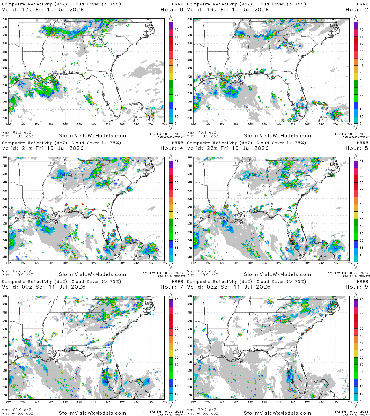
The scattered thunderstorms currently moving inland across Southern Louisiana will lessen up as the day continues. Abundant Gulf moisture and hot, rising air are fueling these storms, and more showers can be expected from the sea breeze and daytime heating throughout the afternoon.
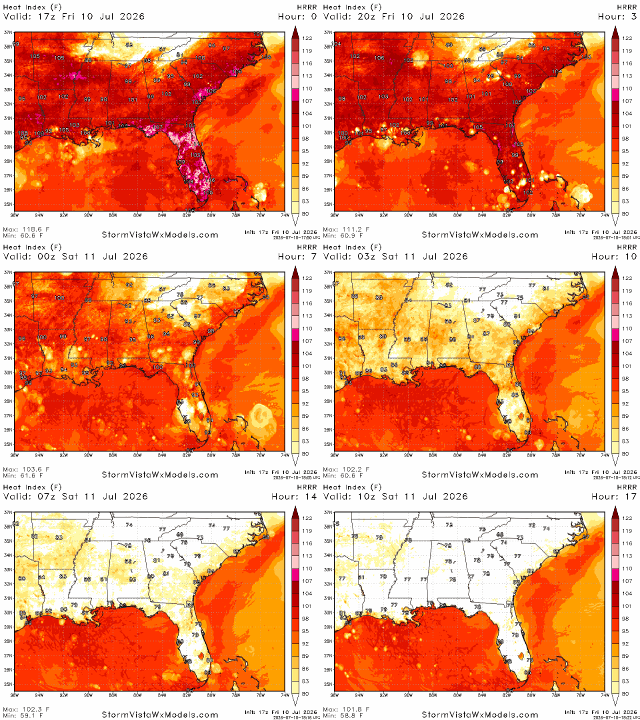
Looking again at our HRRR, we see high heat indices across the southern states with slight dips in temperatures where thunderstorms are expected to develop. The combination of hot temperatures and high humidity is fueling our diurnally driven summer thunderstorm pattern. That means these pop-up storms are developing primarily because of daytime heating, not an organized weather system. As the sun heats the ground, warm, unstable air begins to rise. As it rises, it cools and condenses into clouds, and with plenty of moisture from the Gulf, those clouds can rapidly grow into damaging thunderstorms.
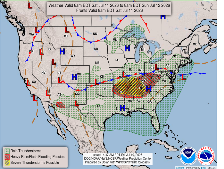
Tomorrow, we see that high pressure remains in control across much of the Gulf Coast, bringing another hot and humid day to Louisiana, Mississippi, and Alabama. Despite the ridge associated with the high pressure, plenty of Gulf moisture and daytime heating will be enough to develop scattered afternoon thunderstorms. The strongest storms are expected across northern Mississippi and Alabama, where a nearby stalled front could push strong thunderstorms southward.
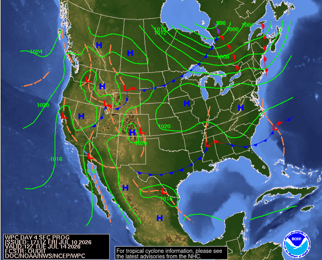
The current trend, which is visible in our 3 day travel forecasts below, is cooler temperatures as we head into next week. Cooler meaning just a few degrees, but sometimes that can make all the difference. As shown above, an area of low pressure is stalling over our area early next week where we have a cold front stretching from West Texas all the way into the Atlantic and a small warm front branching off east of the low. This will bring heavy thunderstorms, potentially damaging wind and rain, and somewhat lower temperatures to the Gulf Coast region.
3 Day Travel Forecast
AIRPORTS
KIAH / KHOU (Houston) – Mild delay risk due to afternoon thunderstorms.
KSHV (Shreveport) – Delays possible Saturday afternoon and Sunday due to storms.
KBTR (Baton Rouge) – Possible delays due to afternoon T-storms.
KMSY (New Orleans) – Delays possible from afternoon thunderstorms.
KJAN (Jackson) – Delays possible with Sunday storms.
KBMH (Birmingham) – Chance for delays in the afternoons as storms build.
KMOB (Mobile) – Potential delays due to storms Saturday/Sunday.
KATL (Atlanta) – Mild delay risk on Sunday due to storms.
KTLH (Tallahassee) – Possible delays from afternoon thunderstorms Saturday/Sunday.
Highways
I-10: Afternoon thunderstorms are to be expected.
I-20: Hot with possible afternoon thunderstorms.
I-49: Higher chance for storms further south, expect afternoon storms.
I-55 & I-59: Hot temperatures with afternoon storms.
I-65: Building storms, especially in the southern corridors.
I-75: Expect stormy afternoons with potentially strong storms, watch out for lightning.
3-Day City Forecast
Houston, TX: Friday (10th): Hot with a chance of thunderstorms. High 93°F, low 80°F.
Saturday (11th): A warm day with afternoon storms. High 94°F, low 80°F.
Sunday (12th): Warm and sunny with an increasing chance for storms. High 93°F, low 79°F.
Shreveport, LA: Friday (10th): Clear and hot throughout the day. High 97°F, low 79°F.
Saturday (11th): Hot with a chance of afternoon storms. High 96°F, low 77°F.
Sunday (12th): Mostly cloudy with showers/thunderstorms. High 93°F, low 74°F.
Baton Rouge, LA: Friday (10th): Sunny with an afternoon thunderstorm. High 95°F, low 77°F.
Saturday (11th): A sunny morning with afternoon T-storms. High 94°F, low 77°F.
Sunday (12th): Partly cloudy with storms building in the afternoon/evening. High 91°F, low 74°F.
New Orleans, LA: Friday (10th): Clear and hot with afternoon storms building. High 92°F, low 80°F.
Saturday (11th): Thunderstorms clearing up by the evening. High 91°F, low 80°F.
Sunday (12th): Cloudy with afternoon thunderstorms. High 90°F, low 76°F.
Jackson, MS: Friday (10th): Clear and hot throughout the day. High 95°F, low 75°F.
Saturday (11th): A sunny morning with a chance for afternoon showers. High 94°F, low 74°F.
Sunday (12th): Cloudy with Thunderstorms. High 90°F, low 73°F.
Birmingham, AL: Friday (10th): Mostly sunny with a chance of afternoon storms. High 93°F, low 75°F.
Saturday (11th): Afternoon thunderstorms possible. High 91°F, low 73°F.
Sunday (12th): Thunderstorms and showers. High 88°F, low 72°F.
Mobile, AL: Friday (10th): Slight chance of storms. High 94°F, low 80°F.
Saturday (11th): Potential afternoon T-storms. High 94°F, low 78°F.
Sunday (12th): Afternoon thunderstorms. High 91°F, low 77°F.
Atlanta, GA: Friday (10th): Mostly sunny with a chance of T-storms. High 93°F, low 75°F.
Saturday (11th): Storm chances increase throughout the day. High 90°F, low 73°F.
Sunday (12th): Showers developing into thunderstorms. High 88°F, low 71°F.
Tallahassee, FL: Friday (10th): Clear and hot throughout the day. High 96°F, low 75°F.
Saturday (11th): Sunny with afternoon thunderstorms. High 96°F, low 76°F.
Sunday (12th): Afternoon thunderstorms likely. High 94°F, low 74°F.


Thank you for the detailed forecast!